Abstract
There is currently very little quantitative information on rates of suppression and water usage from bushfire tankers working the edges of bush and grass fires. This information would be of value to improve suppression and longer-term concerns, such as fleet configuration and maintenance. Fire agencies have begun tracking tankers using GPS-enabled radios to provide location intelligence during deployments. However, more information is required to build a dataset that can be used to estimate suppression rates and to investigate the influence that different factors have on these rates. The data includes fine-scale movements and water use, suppression objectives and environmental conditions. In Victoria, the Country Fire Authority (CFA) has installed a high-frequency GPS, water flow meters and video cameras to a tanker capture this information.
Introduction
The effectiveness of bushfire suppression has mostly been evaluated at broad scales using measures associated with the area burnt and the time taken to contain the fire (Plucinski 2019a). Investigations of suppression effectiveness at finer scales are more difficult to conduct, but are required to understand the productivity of suppression resources in different situations, including their safe limits of operations (Plucinski 2019b). Understanding the use and productivity of fire tankers during fires can inform future investment in the firefighting fleet. While the effectiveness of wet firefighting in grassfires is dependent on many factors other than vehicle specification, understanding travel speeds, flow rates and the role of tank capacity are critical for appliance design. Fire agencies have started to track resources using GPS-enabled radios or other real-time automatic vehicle location transceivers for operational purposes.
In the CFA, automatic vehicle location (tracking) is performed by a system known as the Resource Tracking System (RTS). The RTS records location and speed data from a GPS receiver attached to the vehicle’s mobile radio. RTS data are available for most CFA vehicles while responding to an incident. Data are recorded by the system:
- every 200 m at slow speeds
- every 2 km at highway speeds
- every 30 minutes when stopped.
In addition to variability of speed, critical flow rates and water-tank capacity are fundamental to tanker design and effectiveness in grassfires. Selected flow rates during operations are influenced by factors such as fire behaviour and firefighter training and experience. Operational data are required to investigate the influence of environmental and fire behaviour factors on water use. These data have great potential for the development of suppression productivity models, which could be used to estimate the likely resource and time requirements for a range of scenarios and applied to planning and operational decisions. This paper, examines a novel way in which CFA, in collaboration with CSIRO and industry, is addressing this data need by comparing existing data (from the RTS system) with an Internet of Things (IoT) prototype system retrofitted to an operational tanker.
Methodology
Twenty-one tankers were fitted with an IoT device to capture continuous GPS tracking data at a nominated, high-frequency time interval. The installed tracking systems captured GPS data from the tankers when the ignition was turned on. The systems were accessible through a secure website where data (real-time and historical) could be downloaded and settings, such as the logging frequency, could be adjusted with notifications of activity that could be pre-set. The GPS devices provide data on movement during incidents at a fixed 5-second interval, compared to the speed conditional reporting intervals of the RTS system. The value of these data for analysis is limited without additional information from the crews to provide some context of the corresponding conditions and activity.
Of the IoT connected tankers, one was selected to trial additional instrumentation to relate operational activities to movement and flow rates. This tanker, known as the ‘smart tanker’, was fitted with additional video and water usage monitoring equipment. The smart tanker had 4 cameras placed to provide a visual understanding of the suppression tasks undertaken as well as environmental conditions and fire behaviour (Figure 1a-c).
The cameras were set to begin recording on triggers such as geofences and pump or vehicle ignition activation to avoid unnecessary capture of footage. Examples of the imagery captured by these cameras is shown in Figure 2. The tanker also has 2 flow rate meters (Figure 1d) that were installed to monitor water usage on the deck outlets. These outlets are the primary water source used for suppressing running grassfires. A box containing data loggers and communication devices is mounted to a panel in the firefighting deck (Figure 1e).
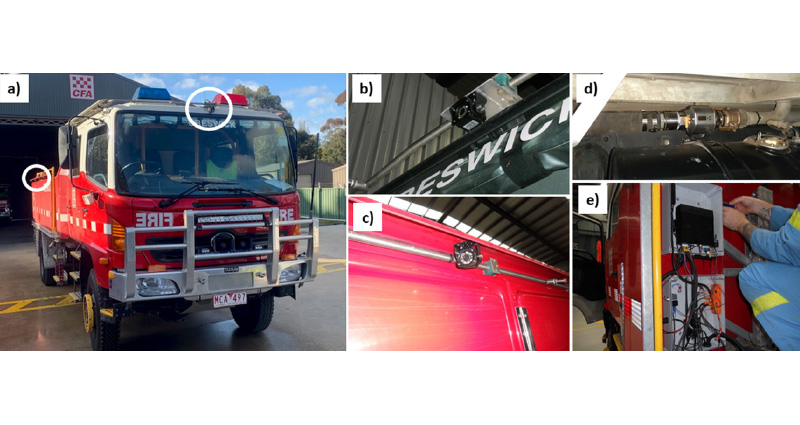
Figure 1: The smart tanker that includes water flow meters and video cameras: a) the circles show the locations of the side and forward mounted cameras, b) the forward-facing camera above the windshield, c) a side (left) mounted forward-facing camera, d) one of the 2 flow meters above the fuel tank and e) weatherproof boxes containing data loggers and modems on the deck behind the left side of the cabin.
Images: Garry Drabsch
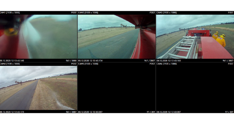
Figure 2: Example screenshot of the view from the 4 cameras installed on the smart tanker: CAM1 rear, right side facing forward (obscured by spray), CAM2 rear left side facing forward, CAM3 rear elevated facing forward showing crew bay and cabin and CAM4 top of cabin facing forwards.
Results
After the smart tanker system was commissioned, a demonstration of the technology was performed, as shown in Figure 3.
The initial trial day proved the system functionality; however, the following fire seasons (2020–21 and 2021–22) were operationally quiet and the tankers were deployed to a few incidents. The smart tanker was deployed to the Langkoop fire on 1 January 2022, but was largely involved with patrol and edge consolidation tasks. Incidents within the brigade area of the smart tanker were quickly extinguished using hose lines while tankers were parked, so deck outlets were not used. One of the high-frequency GPS tankers was deployed to a fire at Beaufort in 2022.
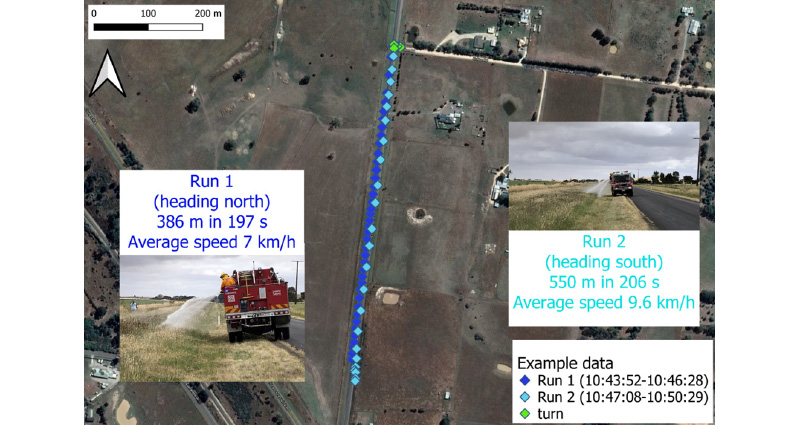
Figure 3: Examples of tracking data collected from the IoT device installed in the smart tanker on the initial trial day (8 December 2020).
In autumn 2022, the smart tanker was taken to the new Central Highlands Victorian Emergency Management Training Centre (VEMTC) to benchmark the systems, as well as to capture basic parameters related to branches, flow rates and wind effects. The data from this day included travel to and from the training facility and was compared with the existing RTS system and the specialised IoT system. The results comparing the speeds measured by the systems are shown in Figure 4.
Comparing speeds derived from the generic RTS and specialised IoT system (Figure 4) shows reasonable agreement. An important note on the RTS speeds is the truncation where speeds are less than 10 km/hr. Examining a short window of time from the benchmarking day, Figure 5 shows the data captured from both systems with the IoT system providing a more detailed picture of the tanker’s speed during testing.
Figures 4 and 5 show that there are limitations to the application of the RTS system for collecting tanker movement data because of the less frequent and irregular track points that do not capture short stops and small variations in speed and direction.
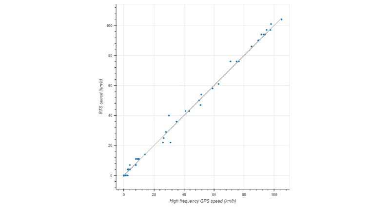
Figure 4: Data from a single day of use of the smart tanker including normal road and highway condition driving, and low speed edge attack simulation. The data compares the RTS GPS-derived speed as is standard on all CFA appliances with the high-frequency system fitted to the instrumented tankers.
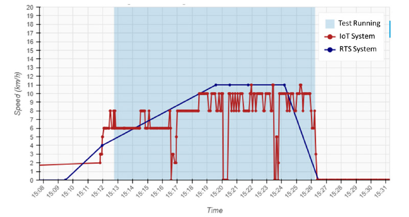
Figure 5: Data from a 15-minute test of the smart tanker in a simulated grass attack comparing the CFA radio-based system (RTS, in blue) and the specialised IoT system (GPS, in red).
Several tests were run during the day to examine the interaction of wind with different hose branches commonly found on CFA tankers. The demonstration of the smart tanker combined with remotely piloted aircraft systems (RPAS) during the nozzle comparison highlighted the possibility for leveraging the 2 technologies for work in the future. Figure 6 shows the set-up for capturing the nozzle comparison data using the smart tanker that is shown in Figure 7.
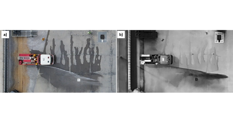
Figure 6: Images from a video from an RPAS in visible colour (a) and thermal infrared (b) showing the nozzle throw distance testing against the wind.
Images: Fire Rescue Victoria RPAS Unit, provided by Dan Green
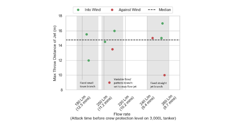
Figure 7: The variation in throw distance from 3 common varieties of hose branches found on CFA tankers, as tested into and with a 22 km/hr wind (as measured at 10 metres).
Discussion
Despite the technical capability of the IoT tankers, they have yet to be used under operational conditions for running edge attack as was simulated without fire in Figure 3. Capturing sufficient data to accurately represent the bounds of safe and effective suppression will require a diversity of case studies. Despite this, the tankers provided opportunities for validating the performance of the RTS system, which has been used in other case study work by Butler, McCarthy and Deutsch (2022). There is merit to leveraging the RTS data as high-frequency GPS may not be required for capturing some types of operational data, such as edge attacks along flanks that extend for multiple kilometres or for providing information on turnaround times between fires and refill points.
Tracking data from systems such as RTS and the IoT GPS can provide useful information on tanker locations at different times. It is collected passively and does not influence the actions of crews. Complementary data are required to give context to this for meaningful analysis. This includes information on the suppression objectives, methods and outcomes, as well as the environmental conditions and fire behaviour. Some of this information can be determined from videos captured on the smart tanker, but much of this needs to be sourced from interviews or surveys of tanker crews. The onboard digital video recording system has yet to be proven as a cost-effective solution for fire behaviour and situational context. However, review of the multi-angle system during the smart tanker deployment to the Langkoop fire suggests it will capture the required data. The ability to trigger recording using the pump ignition is valuable for conserving hard drive space and avoiding recording superfluous footage.
The smart tanker and its flow rate meters proved very effective for a benchmarking study of branch capability from the top deck outlets. Such data are important for studying the limits of suppression capability in different fire weather conditions, and for informing equipment procurement decisions.
The latest installation on the smart tanker has been the addition of a tank-level sensor to the IoT system. On a unit basis, these are more cost effective than flow rate meters but will require testing for the effects of movement and tilt of the tank. The combination of high-frequency GPS, flow rate meters, a tank-level sensor and a multi-angle video recording system on the smart tanker will provide a capable tool for investigating current and future tanker capabilities and capacities. Data captured from deployments and experiments will provide valuable insights into a range of suppression effectiveness questions such as tanker containment rates and water consumption during different suppression tactics and fire conditions.
Conclusion
The IoT smart tanker represents a novel application of existing technology to acquire data for research and development in bushfires. Acquiring data for developing suppression productivity and water-use models requires a sustained effort in resource-level data collection over many fire seasons. While tankers are an important suppression resource type, over time this should extend to other resource types. The data insights from these instrumentation efforts generate value for existing support and strategic investment within fire agencies.