Introduction
In preparation for the 2021–22 summer bushfire season, approximately 60 emergency management specialists from 20 different emergency response and support agencies came together at the Geelong Incident Control Centre in an Incident Management Team (IMT) training exercise. The aim was to plan the response to a mock scenario bushfire threatening coastal townships and summer traffic on the Great Ocean Road within the Surf Coast Shire of Victoria. The scenario was set in real-time, and it tested the IMT’s evacuation decision-making under pressure on a severe fire-danger day. When deciding on evacuation, an IMT Incident Controller considers impact and community preparedness and resourcing often within a limited timeframe in a rapid-onset event. The Controller should only recommend evacuation when it is expected to offer better protection for the community than other options and can be achieved without endangering response agency personnel.
During the exercise, CSIRO/RMIT’s SEEKER (Simulations of Emergency Evacuations for Knowledge, Education and Response) tool was trialled for IMT decision support. SEEKER provides rapid integrated analysis of bushfire, human behaviour and traffic simulations and testing of alternatives significantly beyond the capacity of traditional information sources and processing. It supports timely decisions by providing information on:
- the extent and severity of fire impact to the community
- the complications associated with large numbers of tourists, major events, and transient populations in the region
- the expected response of community members to the fire situation and official warnings
- the impact of activating traffic management plans given available resources
- the trigger points for decision-making
- road speed and capacity constraints with respect to evacuating and background traffic
- unplanned consequences of traffic accidents or blockages as a result of trees over roads
- evacuation outcomes against a base case of no evacuation or messaging; i.e. no intervention.
SEEKER modelling used on the exercise day simulated outcomes of the number of people in high-risk areas affected by the fire (Figure 1), dependent on different evacuation and traffic management strategies employed. The exercise highlighted for the participants the complexity of evacuation in a congested environment, and to the fact that ordering an evacuation, under short timeframes, may worsen the outcome for some people due to traffic bottlenecks that can form.
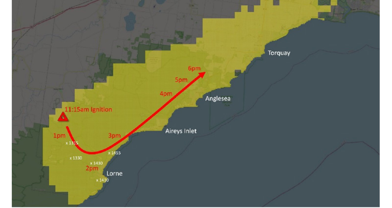
Figure 1: A simulated fire scenario in the Surf Coast Shire used as the basis for the IMT exercise.
Simulations of Emergency Evacuations for Knowledge, Education and Response (SEEKER)
A conceptual model for SEEKER and SAFER is given in Figure 2. These models take as input a baseline representation of the population in the region, its key roads and an estimate of the fire progression, to simulate community response and likely consequences. Underlying SEEKER is a data-driven human behaviour model that captures who is in the region (residents, visitors, etc.) and where (at home/work/shops or travelling to destinations), and how they will respond to the bushfire threat (go home, check on dependents, wait and see, leave) (Singh et al. 2021).
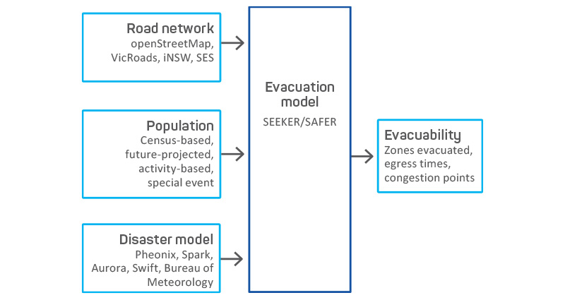
Figure 2: A conceptual model for the CSIRO/RMIT evacuation tools.
To build the synthetic population for a typical midweek summer day in Surf Coast Shire, with associated social and demographic variations, the population was broken into 5 logical groups, being permanent residents, semi-permanent residents, regular visitors (non-holiday visitors from outside the study area), day visitors and overnight visitors. Tabular data were developed for each group including numbers at different start locations, and aggregated spatio-temporal activity (e.g. home, work, shop) distributions for the sample day (Figure 3). These tables were estimated through traffic counts, and local Council studies with the use of census and VISTA transport data. Location data for different activities was developed in QGIS software. Spatial points were derived from several sources, including public address point and point of interest datasets, and supplemented with local knowledge.
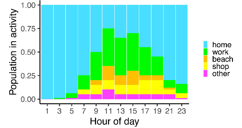
Figure 3: Example expected distribution of daily activities for the resident sub-population used as an input for synthetic population generation.
Once the base data was created, an automated synthetic population generation script (Robertson et al. 2021) produced the population of synthetic individuals with their travel itineraries for the day, that was then used to simulate likely traffic on the day using MATSim (Axhausen, Horni & Nagel 2016). Initial outputs from the traffic simulation were used to undertake a series of adjustments to fine-tune the inputs. Traffic simulation outputs available in visual and tabular form were compared against background data and local knowledge, then input tables for each population group adjusted to better match reality. This largely involved adjusting starting times, destinations and the percentage of users in each sub-category. Capacity and speed attributes on the road network were also adjusted to steer the algorithm to select main thoroughfares for egress routes. Following revisions to inputs, traffic simulations were re-run, and the calibration process repeated, until satisfactory background traffic flows as expected on the sample day were achieved. The final synthetic population (Figure 4) was then used as the input population for all evacuation scenarios modelled in SEEKER.
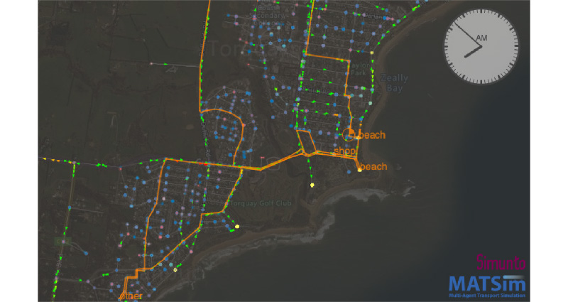
Figure 4: Zoomed view of the output synthetic population showing the town of Torquay. An example synthetic resident's activities and travel legs are highlighted (orange).
Evaluating SEEKER for IMT decision support
SEEKER allows ‘what-if’ scenarios to be simulated, to understand the likely impact of emergency response (sequencing of emergency messages to the community, activation of traffic management points at key intersections to direct traffic), or unforeseen events (impact of road blockages from accidents or fallen trees on egress routes) on evacuation. Table 1 shows evacuation scenarios that were modelled for the exercise.
| Scenario | Evacuation stages |
| S1 | Roads blocked when overrun by fire, no messaging or traffic management in place. |
| S2 | Evacuate message at 1215 hours to all zones, roads blocked by fire as in S1. |
| S3 | Evacuate message at 1215 hours to all zones, implement Traffic Management Plan at 1315 hours, roads blocked by fire as in S1. |
| S5 | Evacuate message at 1215 hours to high-risk zones, implement Traffic Management Plan at 1315 hours; roads blocked by fire as in S1. |
| S7 | Evacuate message sequence to high-risk areas: Lorne and rural at 1215 hours, Airey’s Inlet at 1315 hours, Anglesea at 1415 hours; implement Traffic Management Plan at 1315 hours, roads blocked by fire as in S1. |
Modelling showed that in the hypothetical rapid-onset event, there was insufficient time to safely evacuate the coastal townships along the Great Ocean Road (Figure 5). IMT decisions had to therefore incorporate ‘too late to leave’ situations. Observing the use of SEEKER during the training exercise provided important insights. SEEKER results were used throughout the day to assist the IMT with evacuation decisions and resource management.
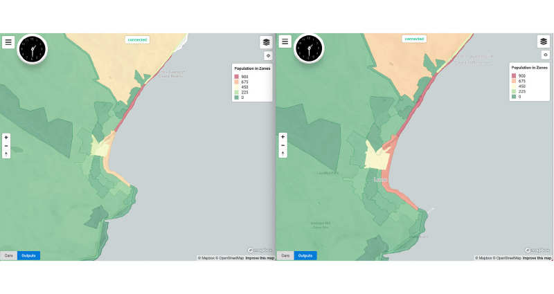
Figure 5: Example SEEKER simulation output showing a significant number of persons around the township of Lorne in scenarios S1 (top) and S3 (bottom) when the fire reached the township.
When first presented with the modelled scenarios, the IMT consulted SEEKER’s outputs to make decisions about evacuating Lorne, the township nearest to fire ignition. A few hours later, the incident controller referred to the outputs again to decide whether to evacuate the townships of Airey’s Inlet and Anglesea as the fire rapidly progressed towards them. SEEKER’s video-based outputs (Figure 6), showing a bird’s eye view of the traffic, were used more frequently during this exercise than the web-based tool (Figure 5) that provided aggregated information on estimated numbers of people in various zones. These preferences highlight areas of interest for future study. SEEKER’s video results were also used to prioritise traffic management points given limited resources available on the day with the mobilising agency.
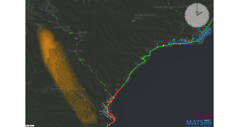
Figure 6: Snapshot of video-based visualisation of SEEEKER simulation outputs.
The debrief session following the exercise provided additional opportunity to obtain feedback from participants. Overall, SEEKER was found to be useful in evacuation decision-making. With that said, the model was considered as ‘one more tool in the toolbox’. Participants reflected that integration of ‘ground truth’ data regarding the fire and road conditions into the modelling would be valuable. IMT members expressed interest in the ability to re-run scenarios in real-time after decisions like mobilisation of traffic management points to assess their effects. Also of interest were data on the numbers of people located in specific locations over time, including campsites in the region. While obtaining these data is a challenge, it is a necessity for any evacuation modelling tool used during fire incidents, which is a future goal in the development of SEEKER.
Discussion
The integration of bushfire models and population evacuation has been reviewed for decision support tools. Initini et.al. (2018) examined 22 traffic models and applications (e.g. TransModeler, DynusT, CUBE) in the context of fire evacuation scenarios in the wildland-urban interface (WUI) and evaluated these models against benchmark features specified for WUI fire applications. Benchmarked features include the 4-step transport modelling framework and its 2 main stages of travel demand and traffic assignment, fire-related factors (affected area, vegetation, meteorology, hazard propagation) and factors related to infrastructure, demographics, human behaviour and network characteristics. Bergstedt (2018) analysed 12 existing traffic models (e.g. Paramics, OREMS, Transims), designed for traffic simulation and for evacuation and their capabilities compared to the benchmark characteristics. Both reviews concluded that most current models still have significant gaps in the integration of the 3 modelling domains of traffic modelling, fire and smoke spread and pedestrian movement, needed for a complete WUI evacuation model.
Three models have been noted that attempt the coupling between bushfire and traffic models. The WUIVAC (Wildland Urban Interface Evacuation) model by Dennison, Cova and Mortiz (2007) combines a simplified traffic modelling approach with a bushfire model that uses trigger points around communities and transport links to initiate evacuations. The dynamic-factors framework by Beloglazov et al. (2016) combines the open-source traffic model Simulation of Urban Mobility with a fire-spread model to compute projections on the behaviour of people and timing of events, and calculate a new risk metric, called exposure count, that quantifies the threat to a population. Finally, WUI-NITY (Wahlqvist et al. 2021), based on the Unity3D game engine, integrates the 3 modelling layers of fire, pedestrian and traffic movement to simulate and visualise human behaviour and bushfire spread. Synergies between WUI-NITY and SEEKER are currently being considered by the researchers involved in these 2 projects.
In addition to SEEKER, as part of the evacuation modelling project1, CSIRO/RMIT are developing a second evacuation modelling software called SAFER (State-wide Analysis of Fire Evacuation Risk). SAFER allows the end-user to compute the maximum theoretical flow supported by the road network through a simplified analysis carried out at the state level across a large set of simulated fires. In this way, it is possible to rapidly identify which communities and roads have elevated risks with respect to those fires. Once these ‘hotspots’ have been identified, SEEKER allows detailed scenario-based analysis of consequences for a single fire, using fine-grained agent-based simulations. Different mitigation strategies and evacuation options may therefore be investigated ahead of time. SEEKER has application in planning, exercising, learning and development, community information and engagement and response.
Research and development of SEEKER and SAFER is ongoing. Stakeholders participated in a collaborative prioritisation exercise to inform the development of these tools. This exercise identified needs and assigned implementation priorities to related functionality (must have, desirable, optional). The results of this exercise were incorporated into a road map of future development for the tools.
Endnote
1. CSIRO Evacuation Modelling, at: https://research.csiro.au/evacuation/.
References
Axhausen K, Horni A & Nagel K 2016, The multi-agent transport simulation MATSim (p. 618). Ubiquity Press.
Beloglazov A, Almashor M, Abebe E, Richter J & Steer KCB 2016, Simulation of wildfire evacuation with dynamic factors and model composition. Simulation Modelling Practice and Theory, vol. 60, pp.144–159.
Bergstedt A 2018, A review of traffic models for wildland-urban interface wildfire evacuation. LUTVDG/TVBB.
Dennison PE, Cova TJ & Mortiz MA 2007, WUIVAC: a wildland-urban interface evacuation trigger model applied in strategic wildfire scenarios. Natural Hazards, vol. 41, no. 1, pp.181–199.
Intini P, Ronchi E, Gwynne S & Pel A 2019, Traffic modeling for wildland–urban interface fire evacuation. Journal of Transportation Engineering, Part A: Systems, vol. 145, no. 3, 04019002.
Robertson J, Singh D, Marquez L, Lemiale V, Ashton P, Dess T, Halliday J, Gamage P & Prakash M 2021, Accounting for seasonal populations in bushfire evacuation modelling and planning: A Surf Coast Shire case study. AFAC22 Conference.
Singh D, Strahan K, McLennan J, Robertson J & Wickramasinghe BN 2021, What will they do? Modelling self-evacuation archetypes. CoRR, abs/2105.12366. At: https://arxiv.org/abs/2105.12366.
Wahlqvist J, Ronchi E, Gwynne SM, Kinateder M, Rein G, Mitchell H, Bénichouc N, Ma C, Kimball A & & Kuligowski E 2021, The simulation of wildland-urban interface fire evacuation: The WUI-NITY platform. Safety Science, vol. 136, 105145.