This paper examines media commentary related to wildfire risk in Aotearoa-New Zealand following two large-scale wildfires that affected urban and rural areas of the country in 2017 and 2019. Surrounding commentary is considered using an established model of disaster risk that highlights the relevance of increased wildfire scale and effects. The model reinforces that increasing numbers of vulnerable dwellings amplify future wildfire threat. The result resembles a ‘multi-headed beast’ of increased risk, one that can be met with a robust set of fire management interventions. Emergency planning frameworks in Aotearoa-New Zealand need to bolster the wildfire risk awareness of landholders as well as local community capacities to manage the potentially elevated levels of overall wildfire risk.
Introduction
The South Island of Aotearoa-New Zealand has experienced two recent major wildfire1 emergencies. The first occurred in February 2017 in the Port Hills area adjacent to the city of Christchurch, in the Canterbury region. The fire burnt an area in excess of 1600 hectares (Langer, McLennan & Johnston 2018) and resulted in the evacuation of 2800 residents. At least 14 homes were severely damaged or destroyed (Christchurch City Council 2018; Langer, McLennan & Johnston 2018). The second fire started in Pigeon Valley in the Nelson/Tasman region in February 2019. It grew to over 2300 hectares and forced the evacuation of around 3000 people and the loss of one home and 1900 hectares of production forest (Nelson Mail 2019).
Pearce (2018) used the Port Hills fire to illustrate how several areas of New Zealand face increased levels of wildfire risk. He proposed that, historically, New Zealand wildfires mostly destroyed fewer residential properties and were limited to much smaller areas. His reasoning was promulgated, to varying degrees, by press media citing a 25 per cent increase in wildfires between 2016 and 2017, with larger wildfires in much closer proximity to metropolitan areas (Wright 2018). Subsequently, Mitchell (2019) cited analysis by Scion (Watt et al. 2019) to illustrate how climate change has increased the amount of dry vegetation fuelling these wildfires, referencing the Intergovernmental Panel on Climate Change (2014) report. The analysis by Watt and co-authors (2019) went so far as to project a 71 per cent increase in ‘Very High’ and ‘Extreme’ fire danger level days2 from 2019 to 2040.
This paper takes a broader look at Pearce’s (2018) proposal and associated predictions by applying the disaster risk framework set out in the National Disaster Resilience Strategy (MCDEM 2019). The framework allows the consideration of several factors that contribute to heightened wildfire risk in the southern-most antipodes. It is hoped this clarification will establish a foundation for further research into, and remedies for, wildfire-related challenges facing Aotearoa-New Zealand.
Defining cumulative disaster risk
The United Nations (2016, p.14) defined cumulative disaster risk as:
The potential loss of life, injury, or destroyed or damaged assets which could occur to a system, society or a community in a specific period of time, determined probabilistically as a function of hazard, exposure, vulnerability and capacity.
The hazard component of this definition aligns with the Australian and New Zealand Standard for Risk Management (AS/NZS 2009) that addresses both likelihood and consequence aspects of risk identification and supports planning to control, minimise or avoid identified risks. The New Zealand National Disaster Resilience Strategy (MCDEM 2019) defines risk using four principle components also outlined in the United Nations (2016) definition:
- hazard
- exposure
- vulnerability
- capacity.
The National Disaster Resilience Strategy calls on emergency management agencies to better identify and manage each component. However, the components are not defined in the strategy document; thus necessitating further definitions from other sources.
For the purpose of this paper, the term ‘hazard’ is: ‘something that may cause, or contribute substantially to the cause of, an emergency’ …. ‘which causes or may cause loss of life or injury or illness or distress or in any way endangers the safety of the public or property’ (Civil Defence and Emergency Management Act 2002, p.9) ‘characterized by its location, intensity or magnitude, frequency and probability’ (UNISDR 2017, para.75).3
The term, ‘exposure’ has also been defined using United Nations Office for Disaster Risk Reduction (UNISDR) terminology as:
The situation of people, infrastructure, housing, production capacities and other tangible human assets located in hazard-prone areas… can include the number of people or types of assets in an area.
UNISDR 2017, paras 69–70
The term ‘vulnerability’ is defined as:
The conditions determined by physical, social, economic and environmental factors or processes which increase the susceptibility of an individual, a community, assets or systems to the impacts of hazards.
UNISDR 2017, para.114
Each of the three components are effectively multiplied by one another to generate an overall level of risk. This overall risk level may be effectively reduced by capacity, which is defined as:
The combination of all the strengths, attributes and resources available within an organization, community or society to manage and reduce disaster risks and strengthen resilience.
UNISDR 2017, para.12
Such strengths, attributes and resources may reduce at least one of the components previously outlined, thus decreasing the overall level of risk. In mathematical terms, this creates an equation where H = hazard, E = exposure, V = vulnerability and C = capacity.
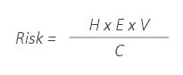
This equation is often used by emergency management agencies as a conceptual framework that helps identify components driving or mitigating risk in notionally at-risk locations. Although it resembles a strictly mathematical calculation, numbers often cannot be assigned or combined to usefully calculate a numerical value of overall level (Aven 2017). Among other implications, this means that many risk assessments rely on judgements and are, therefore, at least partially qualitative. In a similar vein, this paper takes a largely conceptual approach to defining wildfire risk components, in contrast to more quantitative approaches like those documented by Miller and Ager (2012).
Defining increases to cumulative wildfire risk
The following section uses the conceptualisation of risk to define an increasing level of future wildfire risk likely to effect Aotearoa-New Zealand. This increased level of risk results from the combination of increasing hazard, increasing exposure, increasing vulnerability and compromised capacities.
Increasing hazard
The hazard component of wildfire risk appears to worsen in terms of impacts on communities and affected locations, rather than overall frequency. Wildfires have been a frequent annual occurrence throughout Aotearoa-New Zealand this century (Pearce 2018), although there has been an unusual number of wildfire events since 2017 (Langer, McLennan & Johnston 2018). For example, there was an average of 4100 wildfires burning 4170 hectares per year from 2005 to 2015 (Langer & McGee 2017). Wildfires have been frequent but also generally small and controllable, compared to fires in other countries, such as Australia and the US. Figure 1 shows that the number of particularly severe wildfires at the rural-urban interface4 that appears to be increasing. Koksal, McLennan and Bearman (2020) state this represents a grave and under-estimated risk to residents who are attracted by natural environments surrounding properties at this interface.
Wildfires may also become more hazardous as time goes on, especially given the prospect of rising temperatures and less frequent rainfall. According to Reisinger and colleagues (2014), these consequences lead to an increase in both the frequency and severity of wildfires in many parts of the world. The effects of climate change on wildfire frequency and severity have also been highlighted (Brunette et al. 2020, Sanderson & Fisher 2020, Yu et al. 2020, Watt et al. 2019). In Aotearoa-New Zealand, effects of climate change are exacerbated by the retirement of rural pasture properties that had led to increased areas of woody scrub vegetation (Langer & Wegner 2018). Research conducted in the USA (Radeloff et al. 2018) indicated that the retirement of rural pasture properties is related to increases in ignition-prone human activities at the wildland-urban interface.
Increasing exposure
Changes at the rural-urban interface exacerbates the exposure to wildfire risk of life and assets. The Australasian Fire and Emergency Service Authorities Council (AFAC) (2017) stated that the number of houses badly damaged or destroyed by the Port Hills fires made 2017 the most destructive wildfire season in Aotearoa-New Zealand for almost 100 years. Pearce (2018) and Langer and Wegner (2018) outlined how this was worsened by an increasing number of houses being built in locations exposed to wildfire.
Houses and other structures need not be built right next to vegetation to become exposed to wildfire hazards. The long range of ember attacks, along with other vulnerabilities means houses and structures built anywhere within 700 metres of wildlands may be at increased risk (Chen & McAneney 2004). This range may be even greater when ember attacks originate from the stringy-barked species of eucalyptus, as outlined by Gill and Zylstra (2005).
Increasing vulnerability
Communities are increasingly vulnerable to wildfire hazards. This goes beyond location or direct proximity to rural areas. It includes construction, which has traditionally used highly flammable wooden cladding. A 2010 study concluded that just under half of the dwellings were still clad in wood (Page 2010, Statistics NZ 2013).
Lifestyle property houses and suburban sections at the urban fringe of rural-urban interfaces are more closely grouped than infrastructure built for agricultural purposes. Smaller properties and generally denser development means there is less defensible space with reduced fire danger, or safety zone, around homes (Syphard, Brennan & Keeley 2014, Kornakova & March 2017). This can be worsened by flammable exotic garden plantings, such as Australian and South African shrubs, and more flammable native flora, such as flaxes and tussock grasses. These types of plants have become a popular part of residential gardens (Stewart et al. 2004).
Even in the absence of flammable gardens, the ignition of one house is rarely an isolated event in residential areas. This has often lead to structure-to-structure ignition of adjacent dwellings (Cohen 1995; Chen & McAneney 2004; Hakes, Caton & Gollner 2017). An increase in the density of flammable infrastructure is contributing to greater vulnerability in areas already prone to wildfire hazards. The socio-economic vulnerability of many families further exacerbates these issues. Such issues deserve an expansive discussion and are beyond the scope of this paper.
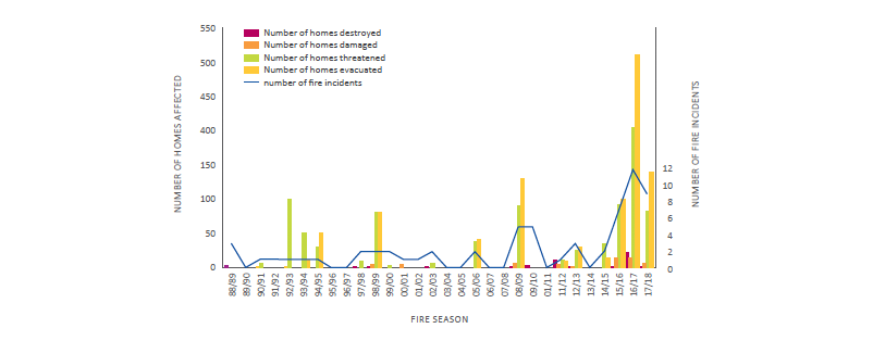
Figure 1: Trends in reported rural-urban interface fire events.
Source: Pearce 2018, reproduced with permission.
Compromised capacities
Increased residential migration into the rural-urban interface may compromise fire prevention, preparedness and response capacities. Jakes, Kelly and Langer (2010) outline that many people moving to the urban fringe and the interface may have no experience with preparing, preventing and responding to wildfire events. Longer-term residents may also be unprepared for the new and rapidly increasing levels of wildfire risk. As outlined in Aotearoa-New Zealand-based research by McGee and Langer (2019), exposure to wildfire events is not enough to prompt local preparedness. Communities may still lack awareness of wildfire risks and appropriate preparative actions (Jakes, Kelly & Langer 2010; Hart & Langer 2014) such as minimising flammable material in a cleared or safety zone around houses and avoiding high risk activities like burning rubbish that can start fires under high fire danger conditions.
Drought conditions experienced prior to the 2019 wildfires in Nelson (Science Media Centre 2019) highlight how wildfire events can form part of a compound, or even cascading, disaster event. As outlined by Cutter (2018), these events occur when a sequence or other combination of disasters are effectively triggered by another. The resulting combination of events can develop to a scale and severity that stretch the capacities of emergency response agencies.
Discussion
Increased wildfire risk can be examined using a model of disaster risk defined by the United Nations (2016), which is being implemented through the National Disaster Resilience Strategy. Components of the model appear to worsen to some extent, including:
- increasing wildfire severity, scale and probability, being driven by climate change and other issues and evidenced by an increase in fire events and impacts at the rural-urban interface
- increasing exposure to wildfires through the proximity of highly flammable infrastructure being built at the rural-urban interface
- increasing vulnerability due to the clustered patterns of development in these areas.
The worsening combination of these risk components signals that increases in overall wildfire risk may not be linear, but exponential. The shift in hazard effects and probability documented by Pearce (2018) is of concern. However, by increasing exposure and vulnerability, which means the predicted increase in the frequency of ‘Very High’ or ‘Extreme’ fire danger days projected to 2040 (Watt et al. 2019), may contribute to a higher level of future wildfire risk. This is because the increasing likelihood of extreme fire events is multiplied by increasing exposure and vulnerability.
Unless counteracted by an equivalent increase in fire management capacities, these compounding aspects of wildfire risk amount to a many-headed beast. Compounding increases to each risk component may prove catastrophic, especially when capacity thresholds, such as local firefighting resources, are overwhelmed. These concepts are not hypothetical especially if Aotearoa-New Zealand follows precedents from Australia to limit increases in firefighting response resources and pursue a policy of shared responsibility. In practice, this means that communities are expected to shoulder more responsibility for responding to the scale of wildfire risks that are being increasingly driven by climate change (Reid, Beilin & McLennan 2020; MCDEM 2019).
New levels of risk may possibly exceed capacities for mitigation, as affected property owners and communities adapt to the new circumstances. Communities with little awareness of emerging wildfire risks are unlikely to be prepared for severe wildfire events. There is an opportunity for rural firefighting capacities to adapt to increased levels of wildfire risk. Some aspects of this are already occurring through improved evacuations for people and animals and added aerial firefighting resources. According to Wright (2018), Fire and Emergency New Zealand (FENZ) have consolidated large-scale response capabilities.
There are opportunities to develop community wildfire prevention and preparedness. These opportunities are being pursued by FENZ, whose activities form part of a long history of proactive fire prevention. FENZ has declared intentions to increase fire risk reduction activities and to improve community resilience (FENZ 2019). These intentions are complemented by a range of associated initiatives, including:
- improving landscape-scale spatial (Kraberger, Swaffield & McWilliam 2018) and land-use planning (Kornakova & Glavovic 2018) using regulatory controls
- improving house construction practices
- using less flammable plant species close to infrastructure
- improving water supplies and firefighting access (Pearce 2018).
These and other proactive approaches are informed by relevant research that supports community disaster resilience across disaster reduction, readiness, response and recovery phases.
Conclusion
This paper reflects on the multi-headed beast of increased risk in Aotearoa-New Zealand; one that requires sound and appropriate emergency planning frameworks. Research-based concepts of compounding and cascading disasters have highlighted how worrisome it can be for government agencies to simply leave communities to their own devices, and to their own potentially inadequate resources. There is a need to better communicate the increasing wildfire risk faced and to help communities adapt to living with worsening wildfire hazards. Much of this increasing risk is due to trends in urban and rural-urban interface development in close proximity to vegetation types, changes in climate and other aspects of physical geography that increase community vulnerabilities.
Further investigating these and other factors will identify geographic areas and communities that most urgently require attention and support towards specifically promoting community wildfire safety. Relevant research in American and Australian contexts provides a valuable background for research conducted in Aotearoa-New Zealand. Further research initiatives commissioned and managed by FENZ, together with research by the Scion Crown Research Institute and other research institutions, are well positioned to meet current and future wildfire risk challenges.