In the early hours of 23 May 1960, an earthquake and tsunami struck Chile. There were no morning television shows and newspapers had already been printed for the day. Tsunami warning systems for Australia did not exist and there were no tools nor knowledge to help Australia prepare. Thankfully, we live in different times.
The 1960 Chilean earthquake remains the largest instrumentally recorded earthquake in the world and the resulting tsunami was observed to travel across multiple oceans. The death toll and damages in Chile are unknown, however, there were many reports of the tsunami impacts on countries across the Pacific Ocean (Figure 1).
Australia was lucky. The tsunami reached the Australian east coast around 14 hours after the earthquake, slightly before it reached Hawaii. By then it was 7:00 pm local time and there were limited activities in the coastal zone. The first tsunami wave was very small and tidal observations show that wave energy built steadily over the following 8–12 hours. In Australia, New South Wales tide gauges recorded peak-to-trough waves between 0.4 and 1.7 metres and observers reported waves up to 4.3 metres in isolated locations.1 A series of waves persisted for the next three days in some locations (Figure 2). The reported wave heights vary greatly from site to site but exceeded three metres (peak-to-trough) in some locations.
Figure 1: This animation recreates tsunami waves travelling across the Pacific Ocean. International figures
taken from the National Ocean and Atmospheric Administration.
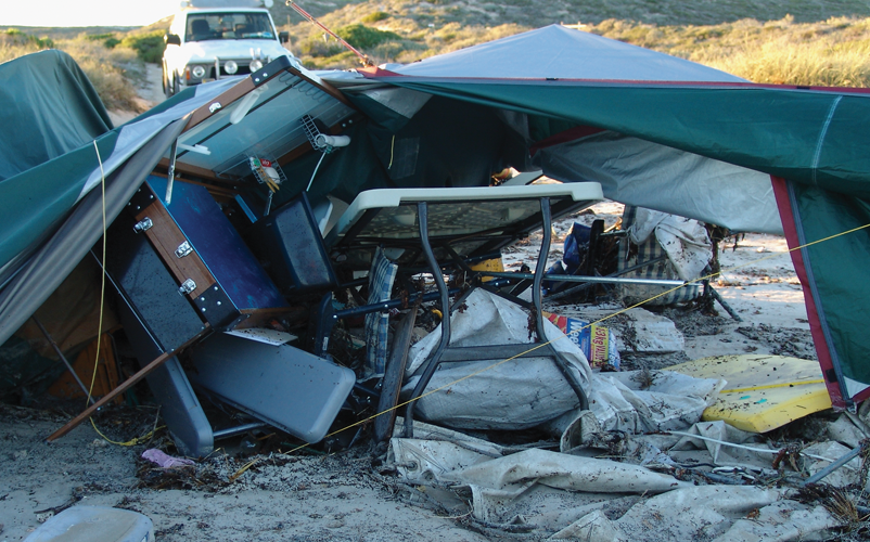
The significant marine effects2 in south-eastern Australia included:
- two vessels sunk; one in Newcastle (a 24-foot fishing boat) and another in Sydney Harbour (a punt loaded with timber)
- two grounded vessels
- dozens of broken moorings (including 30 at The Spit near Mosman in Sydney; the tsunami was reported to produce a large whirlpool)
- erosion of a 90 x 55 metre strip of land at Clontarf in Sydney
- localised run-up in Batemans Bay on the New South Wales south coast
- damages to the oyster industry in the Clyde River at Batemans Bay.
The tsunami was observed within estuaries and harbours in south-eastern Australia. This occurred at areas tens of kilometres inland up streams and rivers due to the narrowing channels of estuaries. There were no casualties, but several injuries and near misses were reported.
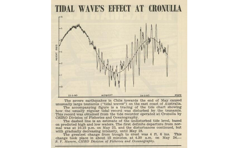
Figure 2: An Australian newspaper clipping from 1960 shows the changes in wave heights recorded at Cronulla, New South Wales. Image source: CSIRO Marine Laboratories – Fisheries Newsletter: Volume 19, July 1960.
Tsunami warnings in 1960
In 1960, receiving regular updates on events that happened elsewhere in the world was not imaginable. There was no social media, no 24-hour news, no images delivered from helicopters as happened during the Tohoku earthquake and tsunami in 2011.
In most cases, people did not receive any warning about the tsunami and instead, responded based on the signs from nature they experienced. In the days that followed, there were aftershocks from the Chile earthquake and warnings related to these reached the Australian Civil Defence and port authorities. However, the aftershocks did not produce tsunami in Australia.
While most people in Australia would have received updates from ABC News via radio or television, few would have known about the event before the first waves arrived. It wasn’t until 25 May, two days after the event, that the Canberra Times front page carried the syndicated story ‘Destructive Tidal Waves Sweep Over the Pacific’ and papers, such as the Hobart Mercury and the Courier Mail, carried stories describing observations in Australia. There were also some local instances of the story, buried among the ads in The Biz on 8 June (Sydney region) and the July issue of the Fisheries Newsletter.
Tsunami warnings today
A lot has changed since 1960. We hear about earthquakes and tsunami almost as they happen via social media and online news. We have also learnt from other tsunami events and put measures in place to offer greater protection.
The 2004 Indian Ocean Tsunami hit close to home and resulted in the establishment of the Australian Tsunami Warning System in 2005, which includes the Joint Australian Tsunami Warning Centre (JATWC).
The JATWC is operated by Geoscience Australia and the Bureau of Meteorology and issues tsunami bulletins within 30 minutes of the origin time of the earthquake. This nationally coordinated warning system is led by the Australian Tsunami Advisory Group (ATAG) and includes tsunami hazard information and a suite of tsunami awareness products.
Most communities in Australia will be warned at least 90 minutes before the arrival of a tsunami’s first wave given Australia’s proximity to major earthquake fault lines. The closest source of earthquake-induced tsunami for the Australian mainland and Tasmania coast is the Puysegur Trench that is south of New Zealand. Some Australian offshore islands and territories are closer to fault lines and may have less than 90 minutes to respond to a JATWC warning. Australia’s location and warning systems allows warnings of possible tsunami to be shared with regional neighbours.
Warning systems are important, but not enough
In 1960, news of the Chilean tsunami reached Hawaii before the waves, yet the country suffered devastating effects. As described by Okal (20113), there was a warning with a call for evacuation at about 8.30 pm local time (3.5 hours before the expected arrival). The first wave arrived in Hilo Harbour just after midnight and was about 1.5 metres. At this point, the alarm was not maintained. Unfortunately, the third wave came ashore just after 1:00 am and was much larger. It ran 12 metres up the coast and penetrated one kilometre inland. It’s not clear whether it was well-known at the time that tsunamis are more than a single wave and that the first wave is often not the largest. This is important information and features prominently in tsunami education materials in Australia.
Australia was fortunate that the 1960 Chile earthquake occurred so far away and so far south on the Chilean coast. If a similar-sized event occurred a few thousand kilometres further north, the impacts on Australia would be very different. Tsunami propagation can be highly directional, as shown in Figure 1. Being far from the source doesn’t mean protection. The impacts on Japan and the Philippines demonstrate that far-field tsunamis can be very damaging. This is why national-scale hazard assessments are so important.
How Australia prepares
The Geoscience Australia Probabilistic Tsunami Hazard Assessment (PTHA4) estimates the likelihood of tsunami wave heights for the Australian coastline as well as offshore territories. The PTHA uses data from historic events, including the 1960 Chilean earthquake and tsunami, to improve estimates of possible future tsunami.
The 2011 Tohuku earthquake and tsunami was a key event that strengthened the PTHA. Prior to this event, the tsunami science community did not think it was possible that such a large-magnitude earthquake could occur in that location. As a result of the Tohoku earthquake, tsunami scientists have been collaborating to revise the maximum magnitudes expected for the subduction zones globally. This had led to major updates in hazard assessments, including to the PTHA.
The PTHA includes earthquake sources from the Pacific and Indian oceans’ basins, with over one million tsunami scenarios. These scenarios are used by government, industry and research sectors to understand the localised effect of tsunamis. Like all hazards, tsunami does not stop at state borders. The PTHA provides a nationally consistent approach to assessing tsunami risk, so businesses and industries with interests across multiple states and territories can understand their overall risk.
The ATAG is an expert advisory group to the Australia-New Zealand Emergency Management Committee. The group provides national leadership in the coordination of programs and projects relating to tsunami capability development, promoting research, information, knowledge management and education in Australia. ATAG members are acutely aware of the challenges in raising awareness of the rarer hazards such as earthquake and tsunami in an environment which frequently experiences bushfires, floods, storms and cyclones.
ATAG uses anniversaries of significant events as a trigger to raise awareness of tsunami and its potential impacts on Australia. For rare hazards such as tsunami, it is perhaps even more critical to use historical events to remind us that Australia is not immune to this hazard.