The challenges facing settlements relating to bushfire require integrated approaches that manage risks across a wide range of factors. This paper sets out a framework demonstrating how urban planning, when coupled with appropriate decision support and future scenario testing, can reduce risks relating to bushfire while considering future growth. Examples of how planning can modify aspects of risk in association with scenario testing are included. Five main categories of risk reduction treatments are shown. The paper contributes to risk reduction by providing practical mechanisms for risk avoidance and treatment via urban and land-use planning systems combined with forward scenario testing to guide existing settlements and future growth.
Introduction
Bushfires pose significant threats to life and property. The frequency and intensity of bushfires is increasing in association with worsening weather conditions that support extreme fires (Dowdy 2018) and ongoing settlement growth (Allen 2018). The intensity, duration and scope of bushfires during the Australian 2019–2020 summer highlighted this, exacerbated by the fact that the highest risks generally occurred when fires impact on human settlements where housing and other structures are in proximity to flammable vegetation. While considerable knowledge already exists in this field, this paper seeks to clarify and strengthen the principles for urban planning as a mechanism for integrated risk reduction.
The challenges facing human settlements relating to bushfire require integrated approaches that manage risks across a wide range of factors. Bushfire frequency, intensity, location and other characteristics influence human activities and the multiple ways the land is occupied. Bushfire risk profiles in a specific location can be understood as a function of the characteristics of the bushfire hazard, exposure to that potential bushfire and the level and type of vulnerability in a given location. These aspects comprise the ‘risk triangle’, shown in Figure 1. On the left are the main elements comprising bushfire risk. On the right, the reduced bushfire risk is shown along with indicative actions that can reduce risks. This paper sets out a framework demonstrating how urban planning, when coupled with appropriate decision support and future scenario testing, can reduce bushfire risks. As a hazard, bushfires progress through landscapes and are influenced by general characteristics of:
- ignition, location and timing
- vegetation fuel loads, arrangement and continuity
- topography
- weather conditions including humidity, temperature, wind speed (Country Fire Authority, 2007).
The risks of negative consequences including deaths, physical and psychological injury, property loss and environmental loss, relate to exposure to the bushfire and being vulnerable when exposed. This can be expressed as a function of proximity to the vegetation that is burning (Blanchi et al. 2014) and being vulnerable to the effects of the hazard such as a lack of shelter for humans and combustibility of structures (Blanchi et al. 2014). Urban planning provides powerful mechanisms to manage and improve many of these bushfire risks.
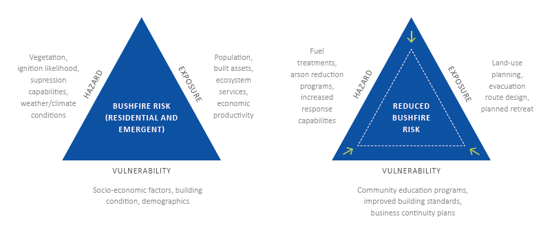
Figure 1: The risk triangle is a combination of exposure, vulnerability and hazard for bushfire risk.
Source: adapted from Crichton 1999
Urban planning and human settlements
While existing urban structures remain as a legacy of previous decisions, most settlements are also dynamic, changeable and multi-faceted in the ways that growth, change and decline occur temporally and spatially (March 2016). Urban planning generally seeks a middle ground between allowing individual and market-based freedoms alongside providing coordinating parameters and minimum standards. This seeks to ensure that overarching economic, social and ecological functions are not undermined by self-interest. It avoids urban development being excessively risky resulting from uncoordinated individual and private interests that ignore overall risk assessments.
Urban planning is essentially a decision system concerned with identifying appropriate land-use and development futures and seeking to bring that into reality. Thus, Australian urban planning should influence many factors relating to bushfire risks even while a range of complicating factors may erode the ability for planning to be effective. These factors include politics, legacy issues, property interests and ineffective enforcement (e.g. see March & Kornakova 2017). In broad terms, the location and design of buildings and the activities conducted on that land are under the remit of zoning, regulation and related systems, such as the building code. The ways in which roads are designed, materials are used in and around structures, land is cleared, vegetation is managed and the size and shape of building lots are generally under the control of planning and building systems.
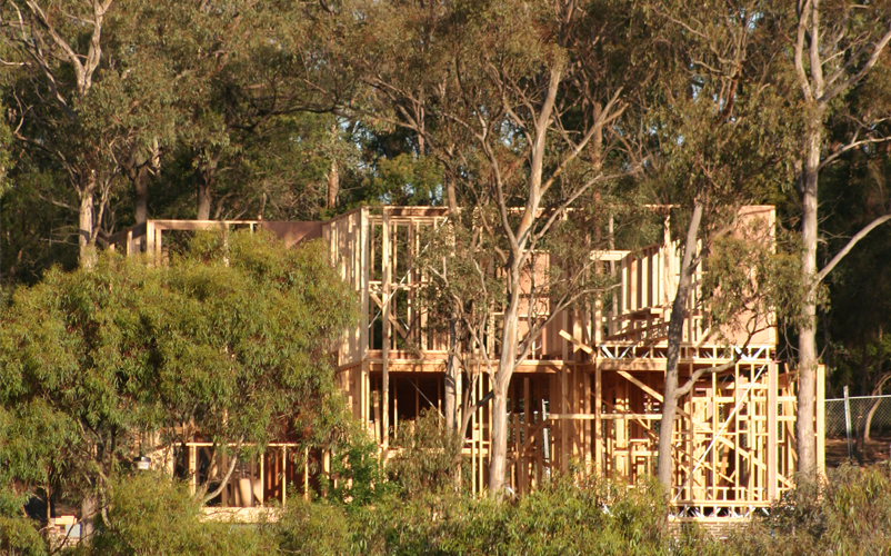
Figure 2 represents a generic layout of a residential development near flammable vegetation. Influencing the structure’s exposure to bushfire is a combination of multiple components including the distance to and type of vegetation, the construction of the property to reduce vulnerability to fire and the road network layout suitable for emergency services response and evacuation.

Figure 2: A property's risk from bushfire includes its location relative to vegetation, access routes and building design.
Importantly, as well as risk-related matters, planning is also required to identify multiple and sometimes conflicting goals such as those linked with economic productivity as well as social and environmental sustainability. These can be challenged by many legacy existing settlement patterns. Further, planning is often confounded by excessive complexity, challenging bureaucratic structures, interest groups, policy failures in relation to climate change, heavy population growth (especially in Melbourne and Sydney) and a lack of information to inform decisions. This paper argues that the potential of urban planning to manage and act on key elements of the built-form relating to bushfire risk can be improved significantly. This can be achieved through consideration of urban planning influence across prevention, preparedness, response and recovery. Using appropriate scenario testing of planning effectiveness under different future conditions highlights urban planning efficacy in bushfire risk reduction.
Urban planning risk treatments for bushfire risk
Avoidance of exposure to hazards
The short-term mechanisms for death and injury resulting from bushfires are heat, flames, suffocation and poisoning. This is followed by secondary causes associated with firefighting or injuries from car crashes or falling trees and debris (Blanchi et al. 2014). Structures are damaged and destroyed by bushfires via heat, direct flame contact, ember attack and secondary aspects such as extreme winds, falling trees and flying debris (Blanchi, Leonard & Leicester 2006).
A risk-treatment approach is to minimise exposure to bushfire, mainly by avoiding exposure altogether in the first place, before any need for subsequent remediation (see Figure 3). A key focus of strategic urban planning is to manage overall residential growth patterns particularly in peri-urban areas. It is at this stage of decision-making that exposure can be limited or avoided altogether. Further, the need for urban planning to manage competing demands avoids some of the detailed issues of self-interest, land ownership, local politics and the ‘work-arounds’ and excessive expenditure resulting from prior decisions.

Figure 3: Through avoiding exposure to the hazard, risks to property are precluded.
In simple terms, if housing, infrastructure and land development and growth are directed away from high-risk areas then risk to property and populations can be avoided altogether. In addition, exposure of emergency responders to further risks is reduced. Locations with high bushfire risk topography, vegetation, weather systems and other risk factors should be identified and assessed early. Urban planning processes and terminologies vary across Australian jurisdictions, but each state and territory allows for the coordination of urban development via growth corridors and plans, settlement area plans and expansion areas. Similarly, parks and reserves, biodiversity areas, farming and rural zones, vegetation protection areas and limited-growth areas can be identified and managed giving consideration to their value as well as to bushfire risks. It is worth noting that even if some areas have been developed previously, it may be worthwhile restricting or modifying future change to appropriately manage risks.
Reduction of hazard impacts or exposure in situ
Urban planning and hazard treatments can be undertaken at a range of spatial scales. It is sometimes appropriate to employ site-based treatments that manage exposure and impacts on communities at the precinct or site scale. This is usually in areas where overall risk is assessed as low or to remediate existing areas. The clearing of vegetation around new or existing structures or urban-edge areas is a way to reduce heat, flame contact and, to some extent, ember attack on structures (see Figure 4). Fuel-reduction measures, often carried out by property occupiers or land management non-planning agencies, can reduce the intensity and behaviour of fires. It is common that clearing or fuel reduction occurs in parallel with new structures being sited (if lot size allows) away from the likely worst effects of a future fire.
The risk treatments described will have implications for other aspects of land and urban management that should be considered. Fuel reduction via prescribed burning or mechanical means has resource and environmental implications as well as aesthetic and health concerns. Further, the density of buildings, sizes of building lots and amount of vegetation clearing required will have implications for social, economic and environmental outcomes. This will also have implications for the multiple goals sought by planning authorities in a location. For example, large building lot sizes may allow for the retention of significant vegetation but result in low yields in terms of new housing provision. Larger lots may also be difficult to service in terms of infrastructure and basic services.

Figure 4: Property occupiers can reduce the bushfire risk reduction by removing vegetation nearest to the property to reduced bushfire hazards.
Reduce vulnerability or increase resistance in situ
Vulnerability is the status of an individual and the ‘extent to which a community, structure, service or geographic area is likely to be damaged or disrupted by the impact of a particular hazard’ (Australian Institute for Disaster Resilience 2015, p.118). Reducing vulnerability in situ, while related to exposure (proximity), is distinct and is a function of the characteristics of the particular at-risk element and its ability to withstand the hazard. In terms of bushfire, this aspect includes social and physical elements (see Figure 5).

Figure 5: Property occupiers can reduce the vulnerability by installing on-site water supplies with a water tank and a sprinkler system.
Improving structures to withstand ember attack, heat and flame contact is a key aspect of physical resistance. It is achieved mainly via the application of building code AS-3959-2018 Building in Bushfire Prone Areas, combined with planning regulations related to siting and vegetation management. Social aspects of vulnerability relate to the variable capabilities and vulnerabilities of people when they are exposed to bushfire. For example, the vulnerability caused by locating aged care, medical facilities, childcare centres or schools in bushfire-prone areas. Additionally, social-economic status and disadvantage typically worsen vulnerability in multiple ways. Other factors such as demographic change over time, can modify vulnerability as the characteristics of a population change.
Australian urban planning systems have traditionally managed land use and development using regulations and issuing permits to ensure compliance with the standards. Significant vulnerability and physical resistance can be delivered by these traditional zoning and regulation approaches. This can be done by withholding permission for development that does not manage risk. Significant gains can be made by improving the physical resistance of structures and by limiting people’s presence in bushfire-prone areas.
Improving response
Response is action ‘taken in anticipation of, during and immediately after, an emergency to ensure that its effects are minimised’ (Australian Institute for Disaster Resilience 2015, p.112). In bushfires these actions include warnings and evacuations; active defence by emergency services personnel, trucks and planes fighting the fire; and rescue operations, provision of relief and medical care. Careful coordination and deployment of resources are key to success during response activities. Integrating related assistance from police, local government, earthmoving companies and interactions with news media are all important aspects.
While urban planning does not play a direct role in response, the design and management of urban areas can significantly affect the need for, and effectiveness of, response at a range of spatial scales. Three main areas of response can be positively facilitated via urban planning (see Figure 6):
- provision of water for firefighting
- ensuring movement in and around settlements, access and active defence facilitation around structures
- location of fire stations, refuges and safer places.

Figure 6: Property occupiers can improve their response capacity with road networks that allow improved access for response vehicles and evacuation.
Response is typically seen as an emergency services agency activity. However, the actions of members of the community related to how they prepare themselves and their homes and their willingness and capacity to evacuate promptly are key aspects in reducing risk.
Improving recovery
Recovery is the ‘process of supporting affected communities in the reconstruction of the built environment, and restoration of emotional, social, economic, built and natural environment wellbeing’ (Australian Institute for Disaster Resilience 2015, p.112). In bushfires, destruction includes deaths; losing houses, businesses and farms; significant changes to the natural environment as well as other far-reaching economic and psychological effects. Recovery can restore as many features of the previous circumstances as possible to assist with a return to normalcy. However, a contemporary view of resilience is that there is a significant opportunity to improve risk profiles during recovery (Meerow, Newell & Stults 2016).
The opportunity to improve risk profiles in recovery is not always taken up. Urban planning in Australia often has limited formal ways to contribute during recovery. An alternative would be to establish mechanisms to identify potential improvements for risk-prone areas before events occur. This could allow considered approaches to be developed. Fundamental improvements to the risk profiles of settlements are possible especially during recovery phases. Realignment of building lots, buy-back schemes and relocations such as the township of Grantham in Queensland after the 2011 floods, improving structures, changes to access and response capabilities and careful location of sensitive land uses are good examples (see Figure 7).

Figure 7: Property owners could reduce risk by making changes to road networks for response access, reducing exposure to hazards by relocating further from a managed vegetation area and improving resistance with provision of on-site water storage.
Decision support systems and scenario testing
Scenario testing of urban planning alternatives allows for policies, plans and infrastructure developments to be tested against future plausible conditions to consider their effectiveness or consequences. In bushfire risk reduction and urban planning, the process of scenario testing can be used, for example, to consider future alternate urban developments against population growth scenarios and their effects on bushfire risks. Scenario testing allows assumptions to be used to assess changes in bushfire risks, how possible growth will emerge into the future and how residual risks vary given factors of population and economic development, climate change on future bushfire intensity and likelihood and influence of urban planning risk reduction measures.
Scenario testing must be transparent, consistent and systematic. Decision support systems allow for the modelling of risk both spatially and temporally and for the implementation of risk reduction options (Newman et al. 2017). The Unified Natural Hazard Risk Mitigation Exploratory Decision (UNHaRMED) support system was designed in Australia in collaboration with government agencies to understand risk and inform risk reduction planning (Riddell et al. 2016). Results from UNHaRMED highlight the role of scenario testing for comparison and visualisation of urban planning risk reduction methods and demonstrating how urban planning can reduce future bushfire risk.
In this paper, comparisons are made for different risk treatments applied to reduce risk in 2050 versus the baseline risk shown in Figure 8, which shows components of risk including vegetated areas and exposed residential and agricultural properties (Figure 8, left panel). The right panel shows the bushfire risk based on fire behaviour, asset exposure, building type vulnerability and response effectiveness. The risks shown relate to vegetation being near to a rural settlement.
Scenario testing linked with urban planning processes are shown to assess growth and change in a region. This allows the spatial expression of dynamic bushfire hazard and risk over time. It also shows the interaction between dynamics such as urbanisation reducing vegetated areas, while increasing exposure and the provision of infrastructure supporting urban growth, as well as ignition likelihood, suppression accessibility and evacuation routes. Figure 9 shows the same area as Figure 8 but, in 2050 (a simulated future using UNHaRMED), considers population and economic drivers. The risk shown is significantly increased due to residential sprawl and a large wildland and urban interface.
The following examples set out core areas of bushfire risk assessment and treatment that can be undertaken via urban planning. Illustrative examples based on scenario testing are provided as an explanatory aid and should be understood as components of overarching risk treatments that integrate a suite of approaches, rather than stand-alone ‘fixes’.
Development in urban fringe areas highlights the vital role urban planning can play in improving the survival of dwellings in bushfire events.
Image: Bushfire and Natural Hazards CRC
Modelling undertaken for this analysis shows results compared against risks in 2018 and 2050 (Figures 8 and 9, respectively) to examine the effects of the risk treatment. Residential growth can be seen in the left-side panel, which is highlighted by the increased risk from bushfire (due to high exposure values) in comparison to Figure 8.
Scenario modelling testing spatial planning to avoid exposure to hazards is shown in Figure 10. This scenario uses zoning to restrict urban development in the areas adjacent to vegetation and instead infills development within the existing urban areas. Comparing Figure 10 to Figures 9 and 8, there is less urban development in risk areas and there is significantly different bushfire risk between the two 2050 scenarios. Reduced ‘extreme’ risk can be seen in areas surrounding vegetation as residential development has been restricted from there, although risk remains ‘high’ due to the value of agricultural activity.
Figure 11 shows the effectiveness of hazard reduction. In comparison to Figure 9 of baseline development and risk in 2050, the left-side panel of vegetated area has been reduced adjacent to residential development. The left and centre section of vegetation has been reduced in area and the right section of vegetation has been removed entirely. This has significantly reduced risk as shown in the right-hand panel.
Figure 12 shows scenario testing demonstrating reduced vulnerability of residential structures to bushfires. The left-side panel has the same hazard (vegetation) and exposure (residential development). However, in the right-side panel in comparison to Figure 9 (with the same hazard and exposure extent), the risk is decreased. This decrease is due to implementing stronger building codes for new developments in years 2018–2050. These new developments have increased resistance to bushfires and a reduced risk is shown in the right-side panel.
Figure 13 highlights the scenario testing showing the influence of urban planning actions to improve response and reduce risk. In the left-side panel (compared to Figure 9) road networks have been improved, including a boundary road between vegetated areas and residential developments. This provides a fire break and improved access and egress for response and evacuation activities. Road networks have been improved and have reduced risks as shown in the right-hand panel (compared to Figure 9).
Scenario testing also provides opportunities to highlight the role of urban planning after events. This is shown in Figure 14 by bringing together many of the other treatment elements shown in previous scenarios for 2050. These include improved road networks for response actions, increased resistance via building and design codes in the built-form and reducing exposure through zoning.
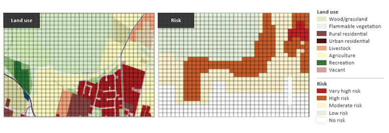
Figure 8: 2018 development layout (left-side panel) and bushfire risk (right-side panel).
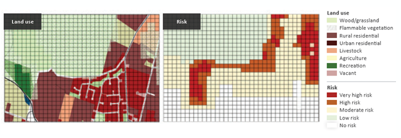
Figure 9: 2050 development layout (left-side pannel0 and bushfire risk (right-side panel). Higher levels of risk can be seen compared to the 2018 risk (Figure 8) due to the expanded residential development and its greater interaction with vegetated areas.
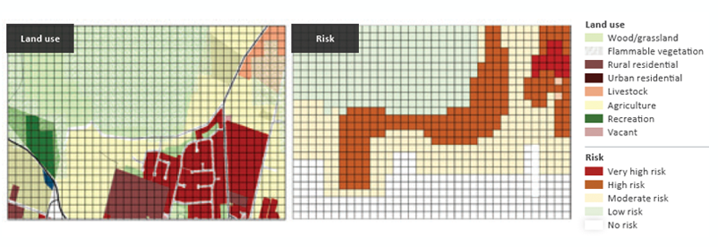
Figure 10: Bushfire risk and development of the rural settlement in 2050 with zoning strategies implemented to restrict development in areas adjacent to vegetation.
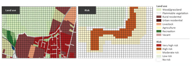
Figure 11: Hazard treatments applied to developments in 2050 shows reduced vegetation in the left-hand-side panel in comparison to Figure 9, showing reduced risk in areas adjacent to the large vegetated area and completely removed in the right-hand section of the risk panel. Although the development is the same as Figure 9, the risk is reduced as the hazard has been.

Figure 12: Scenario modelling of bushfire risk in 2050 with reduced vulnerability to bushfires. The left-side panel shows the development equal to the baseline residential growth for 2050 in Figure 9. The right-side panel shows reduced risk from bushfire compared to Figure 9 as due to improved levels of building controls.
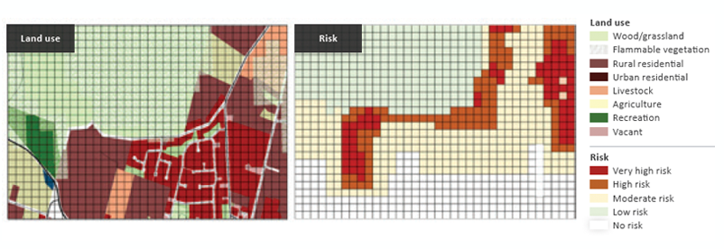
Figure 13: Scenario panel of 2050 with improved response by providing increased connectivity of the road network in the left-side panel compared to the baseline scenario of 2050 in Figure 9. This shows reduced risk in the right-side panel with roads providing fire breaks and access and egress for response and evacuation actions.
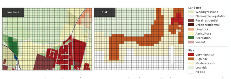
Figure 14: Risk in 2050, when a combination of treatments, is implemented including improved road access, zoning to restrict residential development in areas adjacent to vegetation and improved resistance to bushfires. Compared to Figure 9, changes in development patterns can be seen on the left-side panel and in bushfire risk on the right-side panel.
Conclusion
Treating bushfire risks in settlements requires integrated land-use planning and design. This paper showed ways that bushfire risk profiles can be understood in terms of the interactions of bushfire hazards, exposure to actual or potential bushfires and the level and type of vulnerability (or resistance) of housing and communities in any given location. Treatments of bushfire can be categorised into five types of exposure, reduction of hazard or exposure in situ, reducing vulnerability or increasing resistance, improved response and improved recovery. Ideally, a combination of all five treatments is best; using urban and regional planning combined with building and other mechanisms.
A decision support system was used to model various scenarios of combinations of treatments. Modelling allows the management of urban and regional land to help direct growth and change over time. This allows for the most appropriate management of the risks associated with bushfire hazards while achieving many other objectives possible through urban planning mechanisms.