Abstract
Climate change projections indicate that low-elevation areas along the Queensland coastline will experience increasing adverse effects of submergence, coastal flooding and coastal erosion due to sea-level rise. Current and future climate change scenarios pose significant risks to coastal populations, economies, communities and the natural environment. Without planned pathways and predetermined trigger points for adaptation, coastal environments will remain susceptible to geophysical, hydrological and meteorological hazards. This paper describes hazards (heatwaves, bushfire, floods, storm surges, cyclones and coastal erosion) that impact on lowland areas of the Sunshine Coast region. This assessment is done in the context of converging disaster risk reduction and climate change adaptation strategies using a framework of Define-Analyze-Implement-Reassess.
Introduction
Projected changes in the climate and environment of the Sunshine Coast of Queensland, as well as throughout much of coastal eastern Australia, have been outlined by the CSIRO and BOM (2017), CSIRO (2016) and the Sunshine Coast Council (2014). The changes include continuing sea-level rise, higher minimum and maximum temperatures, more hot days and fewer cold nights, lower annual average rainfall and extended droughts, more frequent and more intense bushfires, more intense storms, increasing tendency for cyclones to track south, increasing risk from large hailstorms and an associated increase in storm surges along the coastline. Most of these changes directly exacerbate specific natural hazards (e.g. coastal flooding and erosion), but some changes can act synergistically to cause multiple or cascading hazards (Sidle et al. 2013). As such, regional protocols are being recalibrated to facilitate future planning and development in low-elevation coastal locations subject to sea-level rise and other climate change phenomena. However, more work and better data are needed to clarify climate-driven trends. It is in this nexus of climate change adaptation (CCA) and disaster risk reduction (DRR) where major challenges for governments and planners lie (e.g. Forino et al. 2014, Sidle, Gomi & Gallina 2017).
There is renewed focus on managing the consequences of climate variability threats by developing actions to protect current and future coastal environments and communities (e.g. beach renourishment, sand dredging,
sea wall construction, foreshore protection). Evidence suggests that land-use planning and DRR strategies require close alignment to build sustainable and resilient communities (Burby et al. 2000, Bajracharya, Childs & Hastings 2011). While these are complementary processes to accommodate predicted climate change, there is a need for improved and ongoing downscaled hazard assessment using a comprehensive approach that embraces the cumulative effects and challenges related to climate change. There is also a need for improved collaboration and shared responsibility to adapt to changing hazard environments and to create motivated populations capable of responding (Attorney-General’s Department 2011). The objective of this study is to identify the cumulative climate influences and hazards that are likely to impact on Sunshine Coast lowlands and to articulate knowledge gaps and converging strategies that support DRR and CCA.
Assessing climate change hazard risk
Once the temporal and spatial aspects of hazards and risks are understood, they must be translated into relevant controls and mechanisms for dealing with them (Attorney-General’s Department 2011). They must be
embedded into strategic planning to anticipate the range of threats that a changing climate may bring (Sidle,
Gomi & Gallina 2017). There is general agreement that more effort is required to integrate DRR with CCA, as
the two approaches converge at global, national and local levels (Asia–Pacific Network for Global Change
Research 2014, Birkmann & Teichman 2010). The Define-Analyze-Implement-Reassess (DAIR) framework
proposed by Sidle and co-authors (2017) emphasises the importance of first defining the temporal and spatial
extent of planning efforts and whether hazards are chronic or episodic (or both) (blue areas in Figure 1).
The link between DRR and CCA is then addressed by articulating different analyses (brown areas in Figure 1)
and implementation strategies (yellow areas in Figure 1) for chronic hazards (e.g. sea-level rise, heatwaves) associated with CCA (as opposed to episodic hazards). Certain episodic hazards, like flooding and storm surges, can be affected by climate change, while other hazards may respond to tipping points that occur when chronic environmental changes decrease ecosystem resilience to the point where catastrophic collapse of process functions occurs (Sidle et al. 2013, Woodruff, Irish & Camargo 2013). The risks associated with chronic hazard change emerge in a slow, but progressive manner, thus periodically reassessing hazard risk is essential (green area in Figure 1). The DAIR framework can help guide initial phases of planning based on improved understanding of changing hazard processes and occurrence across the urban-rural spectrum, as well incorporating multiple or cascading hazards into the decision-making process (see Figure 1).
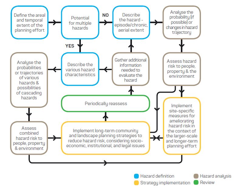
Figure 1: The DAIR framework for initial planning to minimise the effects of natural hazards. Source: Sidle, Gomi & Gallina (2017)
Converging strategies
It is increasingly evident that DRR, CCA and hazard assessment are interconnected (Serrao-Neumann et al.
2015, Thomalla et al. 2006, UNISDR 2009). The terms DRR and CCA represent challenges to ongoing natural
hazards and the emerging issue of cumulative climate change effects. Because DRR and CCA are interrelated
via social impacts, weather and climate, and both are monitored and measured using similar tools and methods to reduce disaster risk (UNISDR 2009), both need to be considered in integrated approaches (O’Brien et al. 2008).
Natural hazard and climate change risk reduction strategies are recognised as areas of convergence (Thomalla et al. 2006) to the extent that they both need to be embedded in sectoral risk reduction planning and urban development processes with a combined ‘all vulnerabilities’ and ‘all resiliences’ approach (Kelman, Gaillard & Mercer 2015). DRR and CCA integration moves beyond contemporary vulnerability and resilience strategies, merging into a single approach focused on simultaneous and common goals (O’Brien et al. 2008, Kelman, Gaillard & Mercer 2015). Despite the convergence of these phenomena, there remains a psychological blockage of their respective commonalities (Thomalla et al. 2006). This blockage may prevent hazard risk mitigation due to the uncertainties of climate change itself, future climate predictions and uncertainty of local climate variability (e.g. Deser et al. 2012). Cumulative climate-related hazard risks are likely to increase, making DRR and CCA key policy goals (Forino et al. 2014).
There is little current evidence of integration of DRR and CCA at local levels (Forino et al. 2014). However, it
is anticipated that as experience with both DRR and CCA strategies grow, recognition that these two fields
share a common focus and purpose will likely increase, reducing the vulnerability of communities, building
community resilience to natural hazards and contributing to sustainable development (Forino et al. 2014, Thomalla et al. 2006). Rather than implementing CCA as a policy independent from DRR, as recently seen in the Australian context due to institutional constraints (Handmer et al. 2014), there is benefit in recognising that climate change is magnifying existing disaster risks and brings a range of emerging cascading hazards.
Climate change impacts on coastal hazards
Geophysical, hydrological and meteorological hazards affect the Sunshine Coast; some are episodic and others are chronic. Here we identify key hazards and climate influences that may impact on Sunshine Coast low-elevation sites under low-to-mid (RCP4.51) and high (RCP8.5) greenhouse gas emission scenarios. It is suggested that the DAIR framework can enhance understanding and reconciliation of the gaps in the DRR-CCA relationship for some of the most important hazards.
Temperature patterns and heatwaves
Increases in temperature are the most direct evidence of climate change. The longest continuous record of temperature and rainfall for the Sunshine Coast is from the Nambour weather station. Records from 1965 to 2017 show no significant trends in the maximum temperatures, while the annual mean of all daily maximum temperatures exhibit a very weak increase (r=0.38) over the 53-year period. As such, better climate data are needed to quantify temperature trends in this region.
Minimum temperatures are expected to increase by between 0.7°C to 1.3°C by 2030, with a further increase of 1.2°C to 2.4°C under a RCP4.5 scenario, or 2.7°C to 4.7°C by the year 2100 under the high emissions RCP8.5 scenario (CSIRO and BOM 2016). The annual average number of days less than 2°C is also expected to decrease to near zero and the days above 35°C are expected to more than double by 2030 (CSIRO and BOM 2016, Sunshine Coast Council 2014).
Directly associated with temperature increases are heatwave hazards. Heatwaves pose the highest risk to life in Australia, accounting for more fatalities than all other natural hazards (Loridan 2016). Between 1844 and 2010, heatwaves accounted for at least 5332 deaths in Australia. Heatwave events are becoming more frequent, hotter, and longer across most of Australia, including the south-east corner of Queensland. The effects of more heatwave days include pressures on human health, crop and livestock losses, and higher energy consumption used for cooling and reduced productivity (NCCARF 2015).
Heatwaves inflict heavy financial losses. The heatwave in southeast Australia in 2009 cost an estimated $800 million due to power outages and disruptions to road and rail transport systems (Chhetri et al. 2012). Evidence shows that electricity supply will come under increasing pressure, resulting in blackouts that affect telecommunications, transport, health services and vulnerable people dependent on power and communication systems. Heatwave-related deaths in Australia are predicted to reach 1250 by 2070, and up to 8628 deaths by 2100 (Bi et al. 2011). Between 1910 and 2015, Australia experienced an increasing trend of extreme heatwave (greater than 35°C) days (Figure 2).
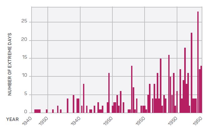
Figure 2: The increasing number of extreme heatwave days > 35°C from 1910 to 2015. Source: CSIRO and BOM (2016).
Using the DAIR framework the temporal increase in heatwaves can be described as a chronic trend. Local implementation efforts to cope and adapt to heatwave events are required. Coupling knowledge from climate science and urban heat island effects with the design of heat stress resistance into the built environment presents a promising pathway for community heatwave management (Hatvani-Kovacs et al. 2016).
Bushfire
Closely associated with warming trends are increased risks of fire frequency and intensity (Grose et al. 2014). Bushfires are prevalent in south-east Queensland and the most severe fire weather typically occurs during spring and summer (CSIRO and BOM 2015). Increased temperatures, higher evaporation rates, lower average rainfall, low humidity and strong winds exacerbate bushfire conditions. In addition, high rainfall during summer and spring increases biomass, thus increasing risks of bushfire during an ensuing period of extended dry weather (Leavesley et al. 2017).
The number of days with a severe fire danger rating is expected to increase by 13 per cent by 2090 under a
RCP4.5 climate model, or 30 per cent under a RCP8.5 climate model. Extreme-rated fire danger days are expected to increase by 15-65 per cent by 2020 and could increase by 100-300 per cent by 2050 if future climate progresses at the RCP8.5 rate (Lucas 2007). It should be noted that these predictions need to be adjusted for localised peri-urban vegetation management and annual rainfall patterns.
While bushfire is an episodic hazard, increases in bushfire risk due to climate change will be gradual. This risk is complicated by urban encroachment into areas that are prone to bushfire. Mitigating fire risk in peri-urban
areas includes using planned and controlled burns, maintaining fire breaks, removing excess vegetation
and the readiness of fire crews (Leavesley et al. 2017). Zoning ordinances to restrict development in areas of
high fire risk are also effective control measures for built environments (Hughes & Mercer 2009) along with the
use of fire-resistant materials in construction.
Rainfall and flooding
Heavy rainfall can result in flash flooding, typically in smaller catchments of the Sunshine Coast, due to the hilly topography. Flash flooding is a significant threat due to the water depth and flow velocity, as well as short warning times associated with these floods. It is predicted that the frequency and magnitude of flash floods will increase with climate change and that historical flood time series data is not reliable for future flood estimates (Rahman et al. 2010). Flood estimates need to account for infrastructure that influences storm run-off, as well as for local climate variability (Rahman et al. 2010). Failure to consider climate change in flood frequency calculations may result in incorrect design storms calculations for water infrastructure. The limited river flow and rainfall records for the Sunshine Coast compromise the assessment of risk trajectories associated with flood hazards and may be the weakest link in predicting extreme rainfall and run-off events for the region.
Climate models project variability in rainfall to range from an annual increase of 17 per cent to a decrease of
30 per cent by 2070. The ‘best estimate’ of projected rainfall change indicates an annual decrease under all
emission scenarios (Sunshine Coast Council 2014). This is consistent with the modest declines in annual rainfall along the Sunshine Coast in recent years. Annual rainfall records for Nambour since 1953 exhibit a very weak declining trend (r= -0.06) from 1953 to 2017 (Figure 3). The subtropical ridge that lies in the mid-latitudes is expected to strengthen and move south by 2.5 degrees over the next century. This could decrease rainfall in the cooler months (Grose et al. 2015). These rainfall projections are also influenced by atmosphere and ocean climate systems, such as the El Niño-Southern Oscillation and the Madden-Julian Oscillation.
The DAIR framework can help coastal communities plan for and adapt to effects of climate change on flood hazards by defining the potential spatial extent of planned urban expansion and the possibility of multiple
hazards (e.g. streambank erosion, interactions between fluvial and coastal hazards). Flooding is a typical episodic hazard that will be influenced by chronic climate change-driven alterations in precipitation and sea-level rise. Hazard probability assessment is compromised by poor data records; thus impacts of climate change on flooding are typically estimated. This weakness lends uncertainty to decisions about implementation of flood
adaptation and mitigation measures (Figure 1). Recent implementation of the Sunshine Coast Disaster Hub
facilitates regional mitigation by providing real-time information on flood inundation patterns, road closures, dam overflows, and power issues (Gallina 2017).
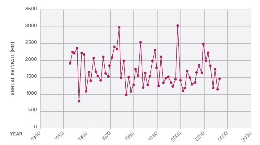
Figure 3: Mean annual rainfall time series from the Nambour weather stations in south-east Queensland (available data from 1953 to 2017).
Sea-level rise
Ongoing sea-level rise associated with climate change is one of the most chronic and widespread hazards and affects other episodic (e.g. coastal flooding) and chronic (e.g. coastal erosion) hazards (Sidle, Gomi & Gallina 2017). The Sunshine Coast sea level is expected to continue to rise with very high confidence (Dowdy et al. 2015). A sea-level rise of 88 cm by 2090 has been estimated using climate model scenarios simulated under the international Coupled Model Inter-comparison Project Phase 5 (CMIP5) (CSIRO 2016). Allowances for increased sea levels is required for a broad range of land-use and planning purposes. It is envisaged that future extreme tides and storm surges will be progressively affected by these increases and changes in storm dynamics (CSIRO 2016). The allowance of 88 cm as a likely sea-level rise provides guidance for sustainable living, future urban development planning, and DRR and adaptation activities. Projected sea-level changes for 2016, 2030 and 2090, relative to the baseline period 1986-2005 and the corresponding extreme sea-level allowance for Mooloolaba on the Sunshine Coast, are shown for low-mid and high emission scenarios (Table 1). These sea levels are the median and 5th to 95th percentile range.
Table 1: Mooloolaba sea-level rise projections. Source: CSIRO (2016)
| Emissions | 2016 | 2030 | 2090 | |||
| Sea Level (cm) | Allowance (cm) | Sea Level (cm) | Allowance (cm) | Sea Level (cm) | Allowance (cm) | |
| Low-mid | 7.2 (4.6 to 9.4) |
8.0 | 14.0 (13.9 to 14.3) |
14.0 | 62.3 (59.9 to 65.9) |
62.0 |
| High | 7.2 (4.7 to 9.8) |
8.0 | 14.5 (14.3 to 14.7) |
15.0 | 88.0 (84.3 to 93.4) |
88.0 |
Storm surges, cyclones and coastal erosion
Higher storm surges and larger spring tides are predicted in coastal zones with increased risk of low-elevation
flooding as a consequence of sea-level rise. The predicted increase in mean sea level is expected to result in an associated increase in tidal extremes such as storm surges and king tides. The frequency of these events is also expected to increase tenfold for every 0.2 metres of sea-level rise (Hunter 2010). Coastline infrastructure, foreshores and populations will become increasingly vulnerable to the impacts of mean sea-level rise. A potential 10 per cent increase in cyclone intensity and frequency, including a southward shift in cyclone tracks, may further increase storm tide levels along the coastline (Queensland Government 2011) due to influences such as the tidal phase, wave set-up, onshore wind force and local bathymetric effects.
Tropical cyclone winds and storm surges are historically the second most damaging natural hazard in Queensland (CSIRO and BOM 2017). Records show 207 known impacts from tropical cyclones along the east coast of Queensland since 1858. Based on CSIRO models (2030 to 2070), the number of tropical cyclones is expected to decline by nine per cent. However, an increase in individual cyclone severity and longevity is projected, potentially lasting several days to a week (Abbs, McInnes & Rafter 2008). The Queensland Government (DERM 2009) estimates an increase in cyclone intensity of 10 per cent by 2100 and forecasts that cyclones may tend to track southwards as global temperatures continue to increase. Cyclone tracking paths may also increase the one per cent annual exceedance probability of storm tide levels; global averages of tropical cyclones may increase 2-11 per cent by 2100 due to warming trends (Knutson et al. 2010).
Eastern Australia experiences large numbers of extratropical cyclones known as east coast lows (Dowdy et al. 2013). A high proportion of heavy rains occurring on the east coast is associated with east coast lows. Increasing greenhouse emissions will lead to fewer east coast lows late in the century, which is consistent with the observed trend of reduced activity in eastern Australia since 1890 (Alexander et al. 2011). East coast lows are now occurring in an atmosphere that has about seven per cent more water vapour compared to 50 years ago, increasing the risk of more intense east coast low events.
Coastal erosion is closely linked to sea-level rise, storm surge, storm tide inundation and cyclone activity. These interactions have the potential to impact on populations and built environments along the coastline. Sea-level rise together with the increased frequency of storm surges will result in increased risks for low-elevation coastal populations and the built environment (CSIRO 2016). Events that influence coastal processes, such as severe storms, tropical cyclones and east coast lows, may increase the overall wave regime and coastal erosion processes (Low Choy et al. 2010), adding further pressures on low-elevation coastal sites. The added risk of a southward shift in the subtropical ridge towards the Sunshine Coast would have a major impact on coastal foreshores (Climate Change in Australia 2015). Any increase in high magnitude storm waves
from tropical cyclones, ex-tropical cyclones and east coast lows will reduce the natural defence mechanisms of the coastal zone (Goodwin, Mortlock & Browning 2016), possibly resulting in planform recession, which may further impact on the coastal built environment. The management of coastal erosion and the impact on coastal locations requires effective coastal hazard adaptation strategies (Low Choy et al. 2010). The DAIR framework (Figure 1) can help guide management decisions by defining the interactions of chronic sea-level rise with storm surge, cyclone and coastal erosion hazards; assessing probabilities of the respective hazards (including cumulative probabilities) and implementing effective planning and adaptation activities to reduce hazard risk (Sidle, Gomi & Gallina 2017).

King tides along Australia’s east coast are natural events that happen twice a year. By 2060 to 2070, Australia could experience tides of at least this magnitude every month due to climate-change sea-level rise. Image: Bruce Miller, CSIRO
Conclusion
The convergence of DRR and CCA strategies suggest that long-term planning and extended engagement
across all sectors and spatial scales are needed to support anticipated climate change-induced natural
hazard scenarios. The DAIR conceptual model can be used to help bridge DRR and CCA and frame long-range
planning decisions associated with coastal hazards affected by climate change. A major impediment for
hazard risk assessment is the relatively short climate and sea-level records in south-east Queensland. The
relatively short period of recorded disasters and climate data have perpetuated a culture of disaster response
rather than mitigation, as noted in the Brisbane River catchment (Sidle, Gomi & Gallina 2017). As such,
innovations like the Sunshine Coast Disaster Hub (Gallina 2017) that provides real-time advice and information, together with improved data collection and analysis at local levels, are needed to support coastal populations, future land-use planning and infrastructure design. Without anticipatory hazard reduction plans and actions, risk for populations and assets that are exposed to coastal hazards will increase significantly in the coming decades.