As climate change escalates and coastal populations increase, adaptation to ongoing risks to coastal communities due to rising sea levels and storm surges must be reassessed. In Australia, over $25 billion of coastal property is at substantial risk from inundation and erosion. The response by governments to coastal hazards has been to construct artificial sea barriers in a hold-the-line approach of investing in sea walls and beach nourishments1 to protect beachfront residential properties. However, are such structures reducing the long-term risk in an era of climate uncertainty? Is sand renourishment of beaches a sustainable solution to increasing erosion on the coast? Can planned relocations be implemented in planning policies? Sea walls perpetuate ongoing threats to coastal development and a shift in the methodology of land-use planning and adaptation for coastal communities must occur. This would be in line with the Sendai Framework for Disaster Risk Reduction 2015-2030 (UNDRR 2015) goal of strengthening disaster risk governance. A greater emphasis must be placed on strategic planning that directs people away from high-risk beachfronts. This research uses qualitative case studies to understand how local governments in New South Wales address the increasing risks to coastal residential development and the connection between government and risk hierarchies. A framework is proposed to integrate national risk hierarchies into state and local government planning to assist in managing strategic relocations and implementing nature-based solutions.
Introduction
Rising sea levels are one of the most significant societal challenges with extreme weather events exacerbating coastal erosion and governments looking to erosion to residential beachfront properties. The NSW Government conducted a statewide exposure assessment of coastal erosion in 2017 and identified over 2,000 residential addresses exposed to erosion risk. According to current development projections, this figure will increase to 3,700 by 2050 due to predictions of rising future sea levels (Office of Environment and Heritage 2017).
The Special Report on Ocean and Cryosphere in a Changing Climate (IPCC 2019) states that sea levels are projected to rise beyond 2100, with one-in-100-day marine heatwave events becoming one-in-4-day events by 2031–2050 (Collins et al. 2019). As oceans warm and sea levels rise, storm surges and extreme coastal events are projected to become more frequent, increasing the exposure and vulnerability of coastal urban developments and ecological systems. Australia’s legislation and adaptation methodology must be reassessed to reduce these long-term risks as over $25 billion of coastal property is at substantial risk (CoreLogic 2022).
As calls from homeowners for greater protection from coastal erosion increase, the effects of bad decisions (e.g. building seawalls) will become more critical. Local governments needs to address coastal erosion adaptation and the equity between politics, private rights, environmental protections and public amenities of the beachfront. There is a growing body of literature on the adaptation frameworks and theories that are all set against evolving climate risk as discussed by Barnett et al. 2014; Cooper 2012; Dedekorkut-Howes, Torabi and Howes (2021); Cooper and Lemckert (2012) and O’Donnel (2016). This paper builds on this significant body of research and aims to contribute with a particular focus on beachfront developments.
Methodology
This research investigates residential land use and adaptation to the risks of coastal erosion, which is a contemporary planning concern occurring across coastal communities in Australia and many other countries. The chosen methodology is the qualitative research method of case studies.
Questions in this research consider how local governments in New South Wales assess risk to coastal development in line with the national risk hierarchies to improve the resilience to sea-level rise and erosion. The case studies were of 2 local governments, Central Coast Council and Byron Shire Council. Both councils have residential development under the same state planning framework that is affected by ongoing coastal erosion issues.
Data for this research were obtained from investigations of legislation and coastal policy documents, semi-structured interviews with elected state government representatives and local councils as well as community focus groups. The data from the interviews, focus groups and literature review were examined by NVivo and thematic analysis.
This research received ethics approval number ME02505 from the Bond University Human Research Ethics Committee.
Legacy development
Part of the problem starts with legacy developments that includes housing in high-risk coastal erosion zones that previous planning decisions allowed to be built without considering climate change concerns, receding shorelines and rising sea levels. An example of a legacy development affected by erosion is Wamberal Beach on the Central Coast area between Sydney and Newcastle.
A parliamentary briefing paper (Smith 2010) on sea-level rise and coastal erosion acknowledged that coastal erosion was a significant concern. The erosion resulted in the loss of residential property and infrastructure related to extreme storm incidents that ‘reflect the inappropriate construction of property within dynamic coastal environments’ (Smith 2010, p.3).
Considering that report and ongoing coastal development with more volatile and extreme weather projected (WMO 2022), the question was put to the research participant planners of both councils, 'Are beachfront developments sustainable in the long term, and how do councils manage legacy development?' Participants from both councils responded that the legacy development vulnerability would increase and that not acting on legacy developments would lead to further economic and environmental damage risk. While participants from the councils and state government representatives indicated that no new housing should be built in high-risk locations, redevelopment continues. A council respondent said, ‘No one is going to say yes, great, put this mapping in; we are happy not to be able to develop more in this area’. This statement highlights the issue with hazard mapping and the private rights of landholders in managing legacy development.
To fulfill the Sendai Framework goals and the United Nations 2030 Agenda for Sustainable Development, governments need to stop enabling development in high-risk zones.

Legacy development on the eroded beachfront of Wamberal, New South Wales.
Image: Mark Ellis, June 2023.
The oncoming financial risks from coastal erosion
Global reinsurer AXA published a 2022 future risk report that lists climate change as the top threat to society, with the physical risks of sea-level and storms being significant consequences of the changing climate. The report states that, ‘rising sea levels and more dangerous storm events could cost coastal urban areas more than USD1 trillion dollars annually by 2050’ (AXA Insurance Reinsurance 2022).
Australian coastal communities will become increasingly vulnerable to rising sea levels and extreme weather events and many beachfront properties will become stranded assets due to loss of property values as well as insurance and banking sectors retracting from the coastal property market. The Reserve Bank of Australia modelled that the number of high-risk properties could grow by over 74,000 due to climate change (Bellrose, Norman & Royters 2021).
American banks and insurance companies are already selling out of beachfront properties in coastal areas in the U.S.A. (Keenan & Bradt 2020). However, coastal property prices in the case study areas have increased. Figure 1 shows the increase in coastal property land values from 2016 to 2022 in the case study areas. The 2021 report on land values by the NSW Valuer General states, ‘The beachside suburbs of the Central Coast NSW experienced the most significant increases’ (NSW Valuer General 2022, p.13). The property plotted for Oceanview Drive was sold in 2016 for $2.6 million, yet in 2022 the land value alone was $4.5 million.
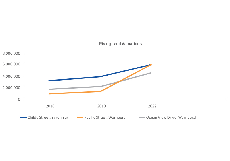
Figure 1: Land valuation comparison in Byron Bay and Wamberal Beach 2016 to 2022. Each plot is for a single address at the location. Source: Data from NSW Valuer General (2022)
While some insurers are opting out of the beachfront market, adaptation finance is being directed towards coastal engineering projects that perpetuate the risk to beachfront housing. Two examples are the proposal to build a pipeline in Adelaide to address beach erosion at a cost of $155 million2 and a $4.5 million funding commitment to repair and restore 170 metres of sea wall at Caloundra.3 The Insurance Council of Australia (2021) estimated that $30 billion needs to be spent on coastal defence projects over the next 50 years to prevent homes from becoming uninhabitable due to the significant risks of coastal inundation and sea-level rise.
Extreme weather and its effects are further highlighted in the 2020 Insurance Group of Australia Severe Weather report that states, ‘Sea level rise will contribute substantially to escalating impacts from storm surges and the effects on coastal natural systems and buildings’ (IAG 2020, p.103).
Planning policy and extreme coastal risks
Storm surges attributed to east coast lows and the southern oscillation El Niño/La Niña system impact on the case study areas. These systems have become more frequent and intense and Vos et al. (2023) emphasise that more erosion occurs under La Niña influence on the Australian east coast. With future predictions of increasing wave intensity and height due to global warming (Morim et al. 2021, p.16), the risk to coastal properties from erosion will be ongoing regardless of emission scenarios (WMO 2022, IPCC 2022).
International and Australian risk frameworks are created to reduce the systemic risk of extreme weather events. Australia is a signatory of the Sendai Framework and local governments have a vital role to play in implementing disaster risk reduction strategies as outlined in the Making Cities Resilient campaign.

Storm surge exposed rocks and damaged infrastructure at Wamberal Beach, New South Wales, July 2020.
Image: Mark Ellis
Research participants were asked, 'How do local governments address the increasing extreme weather to coastal development in line with the national risk hierarchies and the Sendai Framework to improve resilience to coastal risks?' This research identified a disconnect between global, national and local risk planning policies. Some respondents needed to be made aware of Australia’s national risk reduction framework and others did not take the framework into significant consideration but only assessed their decisions on state-based coastal policies.
One participant planner (Byron Bay) highlighted that the statutory framework the councils work under is governed by state legislation. When the NSW Government changed the standard Instrument in 2014 it also standardised the template for e-zones in the new local environment plans (LEP). In doing this, any provision of a coastal hazard zone for appropriate development was removed. The respondent stated, ‘There was no logical transition between councils 2014 LEP, which had an ingrained framework with erosion precincts, and development preclusion zones in the development control plans (DCP)’.
The only thing close to the previous framework of the Byron Shire Council was the 2019 Coastal Resilience State Environmental Protection Policy that morphed into the State Environmental Planning Policy (Resilience and Hazards) 2021.4
Questions about the environmental policy included how future coastal hazards can be anticipated with such complexity of weather events and why property owners can build in a hazard zone, despite the documented risk. Rebuilding in high-risk beach environments is exemplified at Wamberal Beach, where 9 multimillion-dollar developments on the beach have occurred in the last 3 years since the erosion events in 2016 and 2020.
This research also asked, 'Does there need to be a shift in land-use planning and adaptation methodology for coastal communities to address the Sendai Framework and the increasing climate risk of coastal erosion?' The responses were varied. Focus group participants agreed with the question’s sentiments of stopping development in high-risk zones. A respondent from the Central Coast study area considered that there was no legislation to enable such a shift. They suggested that building sea walls was the only response to protect development. In contrast, the council participants in the Byron Bay case study area agreed that a change in land-use policy needed to occur to reduce risks from erosion and that sea walls were not the ultimate answer. This was currently hindered by state legislation.
Beyond engineering
While sea walls and revetments5 may align with a Sendai Framework key action of investing in disaster resilience adaptation, there are practical limits to the effectiveness of engineered structures. As sea levels rise and coastal hazards exacerbate erosion, hold-the-line adaptations will not be able to respond flexibly to the risk. According to Dodman et al. (2022), ‘Globally, it is estimated that as much as USD 94 trillion of investment is required between 2016 and 2040 to replace, upgrade and extend the world’s physical infrastructure’ (sect. 6, 3.5).
The question asked in the research was, 'Do sea walls align with the objectives of the Coastal Management Act 20166 and are they sustainable in the long term?' The viewpoints of participants varied. Some considered sea walls sustainable with limited environmental effects while others were concerned about the varied environmental changes from sea walls and sand nourishment. The concept arose that while sea walls may protect what is behind them, beach erosion can still occur as the structures modify coastal processes and deflect wave energy to adjacent properties and other coastal areas. This alters sand morphology and causes erosion and edge effects as described by the Department of Climate Change and Water (2009), ‘Developed areas of the coast that have had natural dune systems removed and replaced with engineer structures will become exposed to water levels and dynamic wave forces beyond their original designs’. Balaji, Sathish Kumar and Misra (2017) conclude that, ‘the detrimental effects of seawall construction are overlooked in order to preserve the beach and to control the irresponsible shoreline development that takes place along it’ (p.159). With expected sea-level rise and changes in storms to dominate coastal processes over the next few decades (Department of Climate Change and Water 2009, p.34), ongoing sand renourishment for the life of a sea wall will become expensive. This was reported in the cost-benefit analysis within a report to Gosford City Council that stated, ‘the cost of sand replenishment is very high and outweighs the benefits of retaining a beach in front of a seawall’ (Marsden Jacob Associates 2106). Considering the long lead time of adaptation funding and implementation, the moratorium7 on offshore exploration and mining in New South Wales, the effects of coastal squeeze (the loss of beach width due to a fixed position of the revetment wall) and environmental damage, councils in New South Wales should not be allowing walls to be built. Griggs and Patch (2019) state that, ‘The era of routine armour emplacement is coming to an end in California’ and in other countries.
Managed relocation
Griggs (2015) states:
Coastlines globally have been migrating landwards since the last Ice Age ended about 18,000 years ago, and all indications are that this trend will continue in the decades and centuries ahead, at an increased pace as the rate of sea-level rise increase (p.129).
If the data on receding coastlines is considered along with sea-level rise and concerns raised about the exposure of houses on eroding beachfronts, then the managed relocation of residents in high-risk beach environments is a most logical and practical option to reduce vulnerability. Managed relocation, also called ‘strategic retreat’ or ‘planned retreat’, is a land-use management response that involves moving existing properties away from coastal hazards.
Other options of rolling easements, which move the property boundary as shoreline encroachment from erosion and sea-level rise increases, and sea walls that may enable properties to remain on the beachfront are a hold-the-line mentality and is not sustainable or practical in the long term. Marsden Jacob Associates (2106) suggested that retreat provided ‘greater benefits than a continuation of the current approach’ and was the only option with a positive net present value. However, such reports can be dismissed by councils, political representatives and authorities as unworkable due to negative effects on residential landholders’ property rights versus community benefits of the beach and lack of planning frameworks. To implement retreat, councils need to look beyond self-reinforcing feedback of restrictive legislative boundaries that support private property rights. Policy pathway dependency occurs when councils are sympathetic to protecting at-risk coastal properties and are resistant to new ideas, following the status quo of existing policy.
Anderson et al. (2020) highlight that, ‘Managed retreat has been on the global agenda as a sea level rise adaptation strategy since at least 1992’. The IPCC (1992) report stated that ‘only avoidance and relocation can remove coastal risks for the coming decades’ (p.59) and that retreat was a strategy to ‘protect people and ecosystems to shift landward in an optimal fashion’ (p.135).
Figure 2 shows the levels of impact on properties in New South Wales exposed to sea inundation and coastal erosion predicted out to 2060. This numbers of affected properties will increase as the sea level rises and storm surges intensify. The 46,000 at-risk properties could be much higher due to the uncertainties of the Antarctic ice sheet melt and other climate parameters.
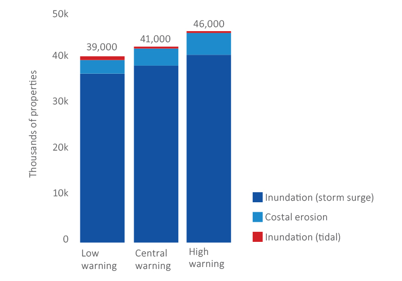
Figure 2: Properties exposed to sea inundation and coastal erosion by 2060–61.
Source: NSW Treasury (2021)
A question asked of participants in both case studies was, 'Will we build walls along the entire coastline of Australia to defend the increasing level of houses coming under risk, or is it better to implement retreat options?' A response was: ‘We are running a hold-the-line strategy and there is no viable mechanism to plan retreat or any government-provided funding to buy susceptible houses out’. In New South Wales, there is the Coastal Lands Protection Scheme8 that has legislative powers under the Environmental Planning and Assessment Act 19799 for acquiring land. The scheme has an annual budget is $3 million and its aim is to acquire scenic and environmental coastal land. However, this scheme could be expanded to purchase land deemed vulnerable to coastal erosion.
The National Strategy for Disaster Resilience (Commonwealth of Australia 2011) presents land-use planning for disaster resilience as essential to shaping resilient communities via adaptation. However, Kellett et al. (2014) recognised an absence of coastal adaptation policy at the national level. This research also found that this problem continues. Implications from climate change demands that land-use planning be based on knowledge of past events and also on future alternative land uses to incorporate flexible responses that foresee future changes (Serrao-Neumann, Harman & Low Choy 2013).
A national settlement strategy advocated by the Planning Institute of Australia (2018) could assist in preparing cities for relocation away from coastlines and the eventual changes due to sea-level rise rather than allowing ad hoc migration during and after extreme weather events. In Australia, there has been limited success with beachfront buyouts for adaptation purposes identified within this research and O’Donnel (2019). Thus, removing the problem of risk and vulnerability in the first place can reduce the bureaucratic processes following post-reconstruction and the costs to communities from severe weather events.
Implementation framework
Risk-based land-use planning is about being responsive to and adapting to natural hazard events. In a changing climate, strategic planners need to match land use with its presented risks. Figure 3 maps a proposed implementation of managed relocation through the various layers of government and policy and identifies how local governments can achieve greater integration with Australia’s national risk hierarchies. It also shows how state and territory emergency arrangements can manage relocations.
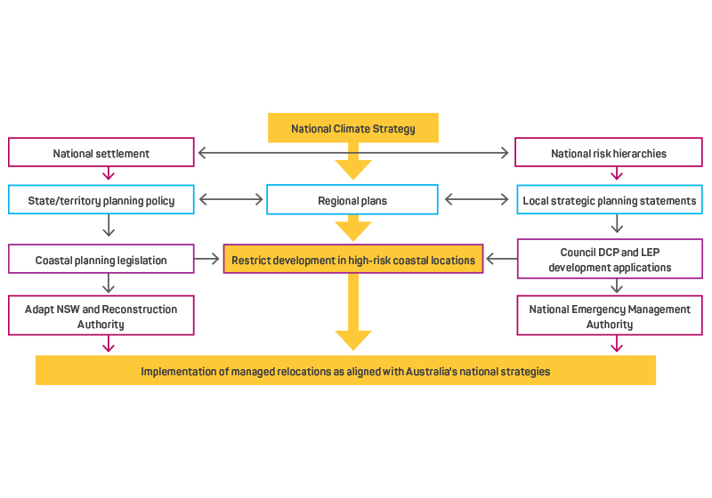
Figure 3: A framework for integrating national policies with local councils for risk reduction via managed relocation.
The point of this diagram is not about ownership of policy, but policy implementation from the national level to align with different state and local government policies. The flow of the diagram starts with Australian Government involvement with a national climate policy that connects with a national settlement strategy and existing national risk reduction strategies. The yellow boxes highlight the end goal of removing development from high-risk locations based on these national strategies. Boxes at the sides direct the actions of the states and territories (left-hand side) and local governments (right-hand side). Implementation must be incorporated in state, regional and local planning legislation and policy implemented via local councils. Funding, machinery-of-government changes10 and descriptions of in-depth implementation are the subject of future research.
Discussion
This study outlined aspects of coastal erosion and the risks to beachfront development from extreme weather events and rising sea levels. It highlighted the differences in adaptation strategies to reduce the risk of erosion. In the Central Coast case study, a self-reinforcing feedback and path dependency approach based on current legislation was adopted. Thus, the council is not reducing the risks from rising sea levels and storm surges by allowing development in high-risk coastal locations.
The Byron Bay case study found that the council wants to act on coastal hazards and looks beyond the current legislative path and has opted for a managed-retreat approach. However, the council is restricted because of the NSW Government intransigence that the strategy aligns with existing government planning policy.
This study did not identify any political will nor appetite for changing public policy to incorporate managed retreat as an adaptation action to reduce risk. The New South Wales planning legislation continues to provide planning mechanisms that allow development in high-risk beach locations and there is no policy to move people away from high-risk zones. With increasing climate risk and coastal erosion impacts, landholders and planners must stop relying on engineering options like sea walls to prop up properties that are no longer sustainable in a climate-affected future. A national coastal reserve that adopts nature-based solutions as a coastal defence and is legislated by state governments and implemented by local governments is a pathway towards reducing the ongoing risks of coastal erosion and sea-level rise. The mechanisms and operations of a national climate coastline reserve is a topic for further research.
Conclusions
This study used qualitative case studies to examine how 2 local governments in New South Wales address the risks to coastal residential development and the connection between government and risk hierarchies. The case studies revealed a difference in council approaches. However, neither council appeared to be effective in reducing the risks to their coastline communities from storm surges and erosion. If beachfronts continue to erode as a result of business-as-usual planning, economic losses will escalate. Current planning practices must evolve to adapt to climate risks.
The implementation of an integrated government approach will better address legacy developments and reduce post disaster reconstruction after storm events. Local councils must incorporate the objectives of the Sendai Framework within their planning structures. Doing so will enhance disaster preparedness and reduce community vulnerability.
Society must take action to address the risks of climate change and its impacts on beachfront developments. To achieve this, all levels of government must work to ensure long-term sustainability with a greater emphasis on strategic planning that directs people and business away from exposed coastline areas.