Ask a Queenslander where tropical cyclones occur and the inevitable response will be, North Queensland. While most of the tropical cyclones have made landfall north of Bundaberg, the cascading and concurrent effects are felt much further afield. The major flooding following Tropical Cyclone Yasi in 2011 and Tropical Cyclone Debbie in 2017 are 2 examples where impacts were felt across the state, and the damage to the banana plantation following Tropical Cyclone Larry (2006) was felt nationally. Acknowledging that climate is influencing the intensity and frequency of intense severe weather hazards, understanding how tropical cyclone hazard varies under future climate conditions is critical to risk-based planning in Queensland. With this climate influence, along with increasing population and more vulnerable building design in South East Queensland (relative to northern Queensland), there is an urgent need to assess the wind risk and set in place plans to reduce the effects of a potential tropical cyclone in South East Queensland.
Preparing for the expected: tropical cyclones in South East Queensland
Introduction
Following Tropical Cyclone Debbie in 2017, the Queensland Inspector-General of Emergency Management (2017) recommended that:
…significant effort should be invested to provide disaster decision makers at every level with a shared understanding of risks, the situation and capability, so that they can agree the best decisions for the communities they serve.
Improved understanding of risk is a central pillar of the National Disaster Risk Reduction Framework (Commonwealth of Australia 2018) and the first objective of the Queensland Strategy for Disaster Resilience 2022-2027 (Queensland Government 2022).
This context led to the initiation of the Severe Wind Hazard Assessment for Queensland (the SWHA-Q project) in 2018. Outputs from the project included a public assessment of the current and future tropical cyclone wind hazard for 2 emission scenarios to 2100 (a first for anywhere in Australia), 2 scenario impact assessments for each of 7 coastal locations, the Tropical Cyclone Preparedness Guide and an operational tool to support preparedness decisions for tropical cyclones (the Tropical Cyclone Impact Model).
The SWHA-Q showed that the South East Queensland region presents an increased risk mainly due to the population density and vulnerability compared to other parts of the state. South East Queensland is home to approximately 60% of the state’s population that resides in approximately one million homes. These homes are designed to resist wind effects from weakened tropical cyclones but are not designed for the effects of high internal pressurisation (e.g. resulting from a failed door or broken window) that can result in a significant increase in loads and can lead to loss of the roof (Figures 1 and 2).
Due to climate change, cyclone intensity, including the amount of rain, is projected to increase. However, it is likely there will be a decrease in the frequency of cyclones (uncertainty). This means that while there will likely be fewer cyclones affecting Queensland, when they do occur, they will be more severe with the potential to cause more damage and, therefore, implications for emergency management. Climate projections also indicate that cyclones will have the potential to travel further south, increasing the risk to South East Queensland.
The SWHA-SEQ project
A partnership was formed with 6 coastal local government areas along Queensland’s coastline (Noosa, Sunshine Coast, Moreton Bay, Brisbane, Redland and Gold Coast), the Queensland Government (Queensland Fire and Emergency Services; Department of Energy and Public Works; Department of Environment and Science; Department of State Development, Infrastructure, Local Government and Planning and Queensland Reconstruction Authority) and the insurance sector (Insurance Council of Australia, Insurance Australia Group and Suncorp) to investigate the nature of severe wind risk in South East Queensland. Geoscience Australia led a Technical Team from James Cook University Cyclone Testing Station and the University of Queensland to analyse the wind risk, the options to reduce the risk and the associated cost-benefit for 6 housing types.
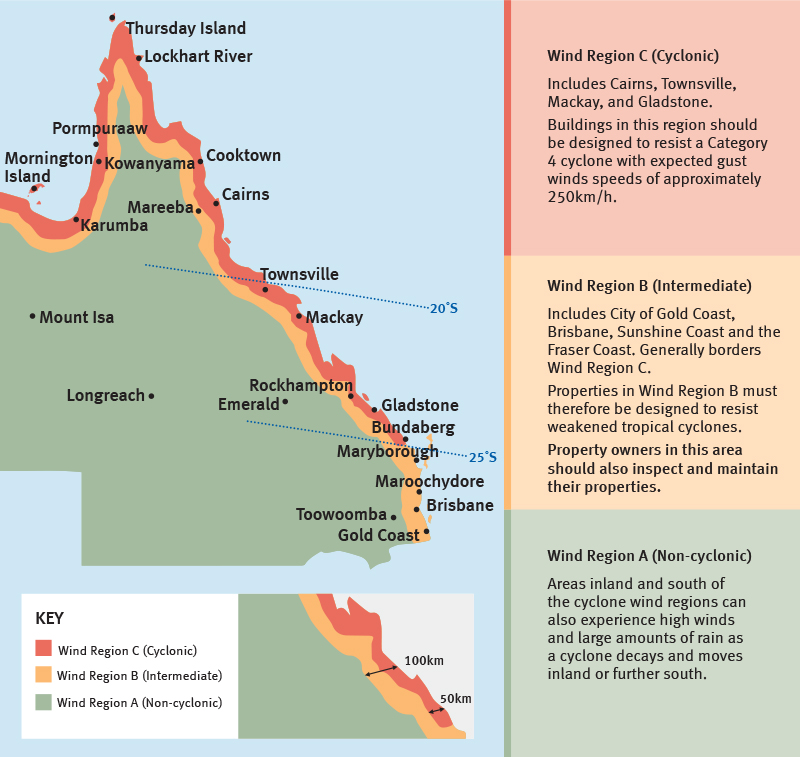
Figure 1: Wind loading regions for residential design standards (AS/NZS 1170.2 2011).
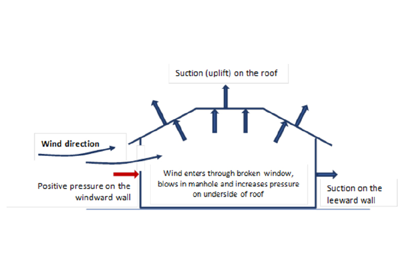
Figure 2a: Wind pressures on building

Figure 2b: Example of damage caused by debris during Tropical Cyclone Yasi.
Source: James Cook University Cyclone Testing Station
The SWHA-SEQ was a major advance on the SWHA-Q. In addition to quantitatively assessing wind risk, advances included:
incorporating thunderstorm wind gusts into the severe wind hazard assessment, with review from insurance industry experts
- developing vulnerability assessments for 6 house types
- applying known retrofit strategies to evaluate the level of risk reduction
- critically (with the support of the insurance sector) quantifying the cost-benefit of these approaches.
These advances were possible due to the enduring efforts of the Technical Team through decades of research and cross-sector collaboration to refine the understanding of hazard, exposure, vulnerability and risk. These components are summarised here at a high level with the Technical Report providing a detailed description of how each of these components was developed and integrated to build knowledge and information that can be applied to inform decision-making.
Geoscience Australia has developed open-source products and data to support hazard risk assessments for more than 20 years. Products used within this project included:
- the National Exposure Information System (NEXIS)
- the National Wind Multipliers
- the Tropical Cyclone Risk Model
- the Tropical Cyclone Scenario Selector Tool.
It is critical for local risk assessments that the estimates of wind speed at the ground level take into account the detail of the topography and built environment that is made possible through the National Wind Multipliers.
University of Queensland staff are expert in thunderstorm hazards and have collaborated with Geoscience Australia to develop a severe wind hazard assessment incorporating both thunderstorm and tropical cyclone. In addition, University of Queensland collaborates with the Cyclone Testing Station in capturing observational data to support continual research using Surface Weather Relay and Logging Network (known as SWIRLNet). A grant was awarded through the Queensland Resilience and Risk Reduction Fund to further this important work.
The Cyclone Testing Station, founded following Tropical Cyclone Tracy in 1974, has been instrumental in providing the evidence to advance the wind loading standard in Australia’s National Construction Code through post-disaster damage assessments, engineering testing and research. In partnership with Geoscience Australia for more than 15 years, damage models have been developed for typical residential house options to support hazard and risk assessments. For the SWHA-SEQ project, the Technical Team determined a set of generic house types in Queensland’s building stock through street surveys and analysis of the NEXIS database.
The project developed a suite of these models for 3 retrofit options that are available through the Queensland Government’s Household Resilience Program. This program has received further funding through Round 1 of the Disaster Ready Fund to continue to enhance resilience to tropical cyclone in North Queensland communities. The SWHA-SEQ project’s key question is understanding the cost-benefit of the retrofit options. The reduction in insurance premiums was informed by the insurance sector to enable analysis.
The damage models were coupled with hazard scenarios to develop scenario impact models for both planning and preparedness in collaboration with the Queensland Fire and Emergency Services. For this project, 5 impact scenarios were developed and chosen from Geoscience Australia’s Tropical Cyclone Scenario Selector Tool. Scenarios were based on expected maximum winds; comparison to historical events such as Tropical Cyclone Dinah (1967), Tropical Cyclone Hamish (2009) and Tropical Cyclone Oma (2019) and the effect felt across the local government areas in the study.
The project considered the role of community resilience through the use of the Australian Disaster Resilience Index1 (ADRI) into the quantification of risk. The ADRI was used to effectively moderate the insured risk to highlight those areas that would potentially be greatly affected by tropical cyclone. The project also used the ADRI to prioritise a hypothetical resilience program, that is, to direct valuable budget (from a government and individual level) to those who need it. This relatively new approach has been adopted by Geoscience Australia in other projects (see for example, Edwards et al. 2015). At this stage, the cost-benefit analysis was based on direct costs only.
In 2021, during the SWHA-SEQ project, Tropical Cyclone Seroja hit the Western Australia coast in wind region B, with devastating consequences. Wind region B is known as the intermediate region, designing for wind speeds up to 205 km/hr. The coastal regions with latitudes greater than 250 in Western Australia and Queensland are defined to be in wind region B. Around 10% of contemporary houses in Kalbarri in Western Australia were significantly damaged and uninhabitable from Tropical Cyclone Seroja. That cyclone crossed the coast at approximately the same latitude as the east coast city of Coolangatta in Queensland, which reinforced the importance of the SWHA-SEQ project.
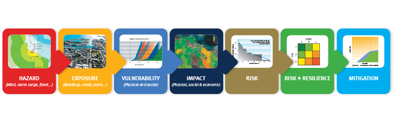
Figure 3: Method used for the SWHA-SEQ project.
The project developed a suite of these models for 3 retrofit options that are available through the Queensland Government’s Household Resilience Program. This program has received further funding through Round 1 of the Disaster Ready Fund to continue to enhance resilience to tropical cyclone in North Queensland communities. The SWHA-SEQ project’s key question is understanding the cost-benefit of the retrofit options. The reduction in insurance premiums was informed by the insurance sector to enable analysis.
The damage models were coupled with hazard scenarios to develop scenario impact models for both planning and preparedness in collaboration with the Queensland Fire and Emergency Services. For this project, 5 impact scenarios were developed and chosen from Geoscience Australia’s Tropical Cyclone Scenario Selector Tool. Scenarios were based on expected maximum winds; comparison to historical events such as Tropical Cyclone Dinah (1967), Tropical Cyclone Hamish (2009) and Tropical Cyclone Oma (2019) and the effect felt across the local government areas in the study.
The project considered the role of community resilience through the use of the Australian Disaster Resilience Index1 (ADRI) into the quantification of risk. The ADRI was used to effectively moderate the insured risk to highlight those areas that would potentially be greatly affected by tropical cyclone. The project also used the ADRI to prioritise a hypothetical resilience program, that is, to direct valuable budget (from a government and individual level) to those who need it. This relatively new approach has been adopted by Geoscience Australia in other projects (see for example, Edwards et al. 2015). At this stage, the cost-benefit analysis was based on direct costs only.
In 2021, during the SWHA-SEQ project, Tropical Cyclone Seroja hit the Western Australia coast in wind region B, with devastating consequences. Wind region B is known as the intermediate region, designing for wind speeds up to 205 km/hr. The coastal regions with latitudes greater than 250 in Western Australia and Queensland are defined to be in wind region B. Around 10% of contemporary houses in Kalbarri in Western Australia were significantly damaged and uninhabitable from Tropical Cyclone Seroja. That cyclone crossed the coast at approximately the same latitude as the east coast city of Coolangatta in Queensland, which reinforced the importance of the SWHA-SEQ project.
Observations
This project started the journey to quantify and make publicly accessible the tropical cyclone wind risk. There are known gaps. The analysis doesn’t include all stand-alone residential buildings, strata-title or commercial buildings nor is storm surge or flooding considered. The cost-benefit is based on direct costs of rebuild without also including the costs to the community in terms of disruption, dislocation and broader scale community affects. There is a substantial body of work to incorporate these indirect costs to the community and to government in a future analysis. Without these indirect costs included, the analysis shows that retrofit for the majority of residential houses (79%) assessed (in lower-hazard site conditions) is not cost effective. A significant degree of cost sharing is needed to adequately incentivise retrofit action for houses in higher-hazard site conditions. A program similar to the Household Resilience Program2 in North Queensland could achieve a meaningful reduction in severe wind risk if implemented across the high-hazard sites. With strata-title properties representing an increasing percentage of the building stock, this analysis is under-estimating the cost-benefit of retrofit.
While the risk is driven by tropical cyclones, thunderstorms are a regular occurrence and present a continual risk to residents. The challenge is that while the frequency of tropical cyclones is expected to reduce, the intensity is expected to increase. The issue is exacerbated with the expected growth in populations and the pressures that will place on residential development planning. This may further concentrate current development resulting in an increase in the proportion of strata-title properties and the potential scale of damage from a single event.
Table 1: Indicative building counts of damage state in the 6 local government areas of the scenario.
| Local government area |
Negligible | Slight | Moderate | Extensive | Complete |
| Noosa | 5,500 | 0 | 0 | 0 | 0 |
| Sunshine Coast | 57,900 | 9,800 | 1,400 | 1 | 0 |
| Moreton Bay | 83,600 | 47,300 | 15,000 | 1,900 | 0 |
| Brisbane | 188,100 | 91,000 | 39,000 | 4,300 | 0 |
| Redland | 13,400 | 6,900 | 13,000 | 30,300 | 365 |
| Gold Coast | 28,400 | 21,000 | 36,900 | 99,400 | 815 |
Previous cyclones have highlighted that buildings can sustain damage for wind speeds less than what they are designed for. This damage results from the wind and rain. The level of maintenance, poor design and detailing may contribute. This is an additional layer to the wind loading requirements for the region. It is worth noting that Western Australia has amended these requirements in the wake of Tropical Cyclone Seroja where the affected population is significantly smaller than South East Queensland.
Quantifying wind risk is critical to support future resilience programs and any amendments to the wind loading standard. However, there are immediate, high-priority concerns for local government stemming from the project. Current homes and evacuation centres in South East Queensland may not be suitable places to shelter in a severe tropical cyclone event. The Technical Report provides guidance to assist with the identification of places of last resort that include engineering assessment and consideration of non-conventional forms, such as multi-storey car parks.
The report highlights the need for more research across a range of elements (hazard, exposure and vulnerability) to provide a complete picture on the risk posed by severe wind events and what resilience options there may be to reduce that risk. Key areas include risk to strata-title properties, uncertainty in tropical cyclone wind hazard, projections of thunderstorm hazard and a multi-hazard risk assessment including flooding and storm surge.
Applying the scenarios
Scenarios are stories that convey how a hazardous event is expected to unfold. They are often used to assist decision-making and to help understand the concurrent, compounding and cascading ways that hazardous events could unfold. As such, scenarios can support local risk-based planning including identifying risk treatments, conducting disaster exercises, developing evacuation plans and informing community awareness initiatives.
The project developed 5 impact scenarios to help stakeholders assess local effects and risks within their areas of interest. The scenarios represent wind speeds of Category 2 and 3 cyclones and were chosen based on the expected swath of maximum winds, consideration of historical events and the propensity to affect all local government areas in the study region. While the probability of these events occurring are low, the scenarios are plausible and provide examples of the damage to stand-alone residential buildings that could occur based on detailed scientific modelling and analysis.
The first of the scenarios in the Technical Report was used for one state and 2 local disaster management exercises, being Exercise Averruncus (QFES 15 June 2022), Exercise Miberran (Redland City Local Disaster Management Group 8 November 2022) and Exercise Enigma (Gold Coast Local Disaster Management Group 24 Jan 2023). The scenario was a Category 3 cyclone crossing the coast near Wellington Point near Brisbane with strongest winds experienced across Mulgumpin (Moreton Island) and through the Gold Coast including the hinterland regions (Figure 4). The cyclone continues to dissipate as it progresses into northern New South Wales.
As expected, given the wind field, there is very limited damage sustained in Noosa and only a small fraction of buildings in the Sunshine Coast sustain moderate damage. Southwards, and closer to the track of the cyclone, the effects increase through Moreton Bay, Brisbane and Redland. The Gold Coast sustains extensive damage in this scenario, with nearly 100,000 houses extensively damaged and another near 37,000 sustaining moderate levels of damage. Only a small number of regions in the Gold Coast are rated as ‘complete damage’ (Figure 5) but these are in the hinterland where local wind speeds are high due to the steep topography. Table 1 summarises the residential building damage for the region.

Exercise Averruncus at Kedron-Wavell Services Club on 15 June 2022
Images: QFES
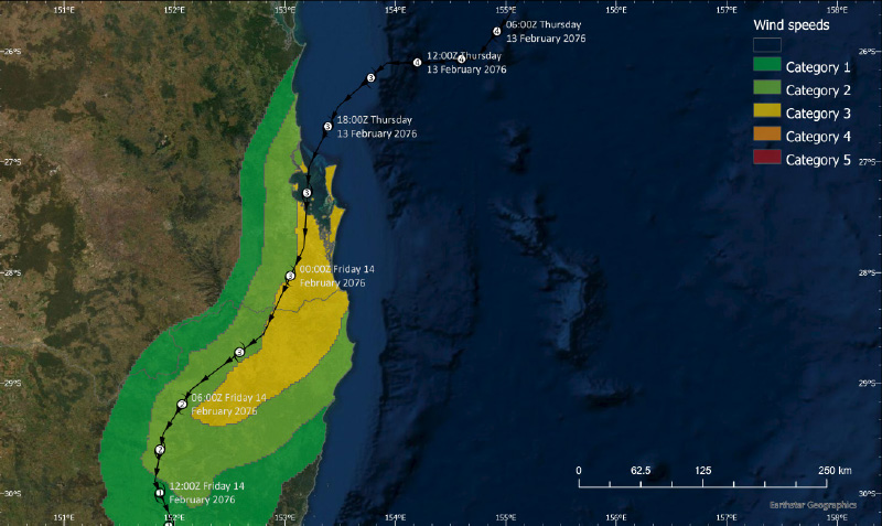
Figure 4: Track and regional wind field of a hypothetical tropical cyclone passing over South East Queensland. This wind field is modified by the effect of topography, land cover and the built environment to evaluate the effects.
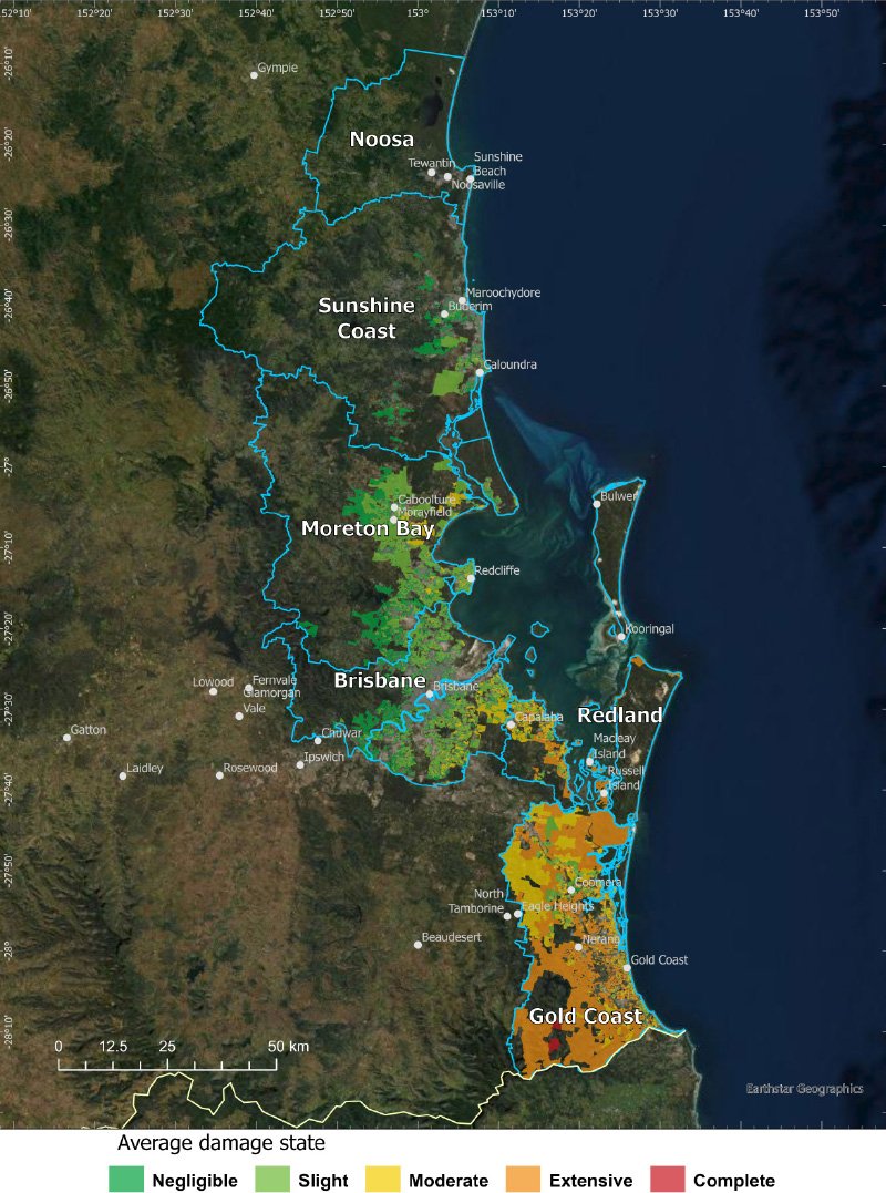
Figure 5: Mean damage state of residential houses, aggregated to meshblock level for the Tropical Cyclone scenario used in Exercise Averruncus (and others). Damage was calculated for residential houses only in the 6 coastal local government areas.
The first state-level exercise exposed participants to a hazard many may have had very little experience with. Exercise participants were reminded that these events are possible at these southern latitudes, which the Cyclone Testing Station damage assessment from Tropical Cyclone Seroja highlighted. While the project had developed residential affect, it was important to include the effects to critical infrastructure operators (power, water, transport, communications) to the exercise. The scenario showed the significance in the scale of impact and signalled a need for a major, long-term recovery effort. The most important information provided to participants was the evacuation modelling conducted by CSIRO/Data 61 that highlighted (with optimistic assumptions) that mass evacuation would not be possible. This points to an urgent need to develop community messaging with serious consideration being given to shelter-in-place information.
This state-level exercise was followed by 2 separate, local disaster management exercises to discuss these issues in detail. The state-level exercise on its own is not sufficient to form the basis of local government planning. This needs the participation of the Local Disaster Management Group and the entities with responsibility for disaster management. The exercises were structured to identify the actions, challenges or capability gaps across 3 phases; (i) preparation (ii) warnings and evacuation and (iii) response, relief and short-term recovery. Both exercises rotated participants around the tables to provide opportunity for networking, cross-fertilisation of ideas and to maintain energy and momentum throughout the day. Both exercises used an online polling platform technology to capture participant feedback.
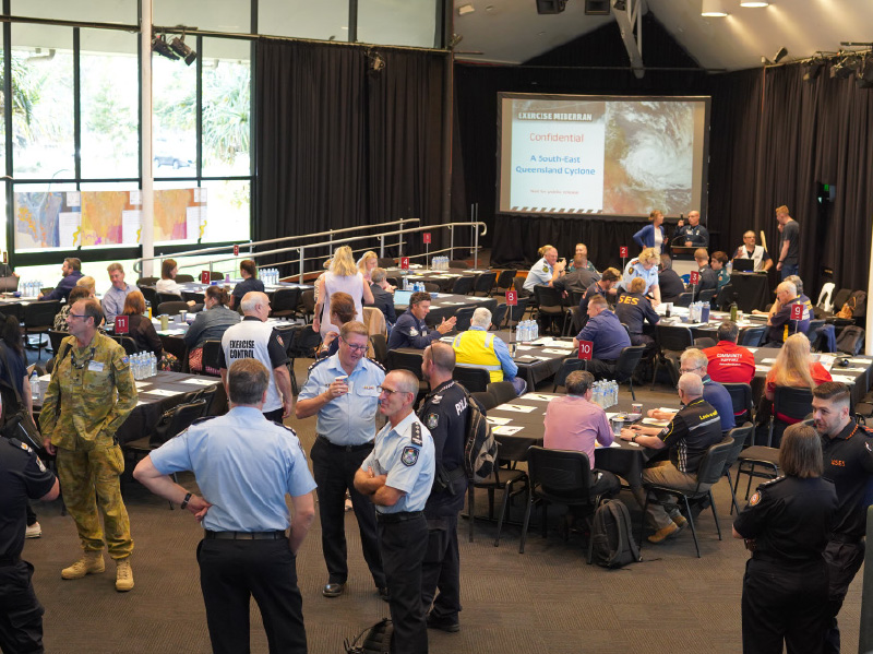
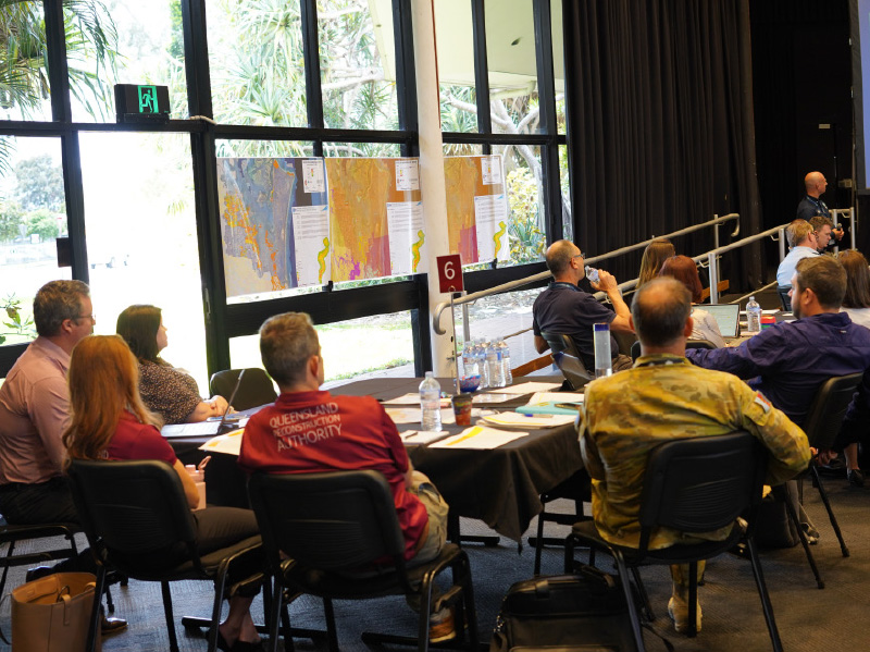
Exercise Miberran, Redland City Local Disaster Management Group, 8 November 2022.
Images: Redland City Council
The outcomes of the exercises form the basis of work plans for tropical cyclone risk for Redland City Council and the City of Gold Coast. Components of these work plans include:
- developing a tropical cyclone subplan
- planning longer-term recovery
- assessing options for evacuation sites
- identifying places of last resort
- developing an engagement and education strategy
- reviewing business continuity plans
- reviewing locations of key assets (such as emergency response vessels)
- assessing harbour safety
- further exercising.
In the case of the City of Gold Coast, a stand-alone project has been initiated—Project AIR (Advocacy, Information and Resilience)—that has been resourced over 5 years to harden places of last resort, embed the engagement strategy and influence better community safety outcomes for the Gold Coast community and visitors. To begin exploring the risk to strata-title buildings, the City of Gold Coast has been successful in the first round of the Commonwealth Disaster Ready Fund with a $400,000 strata study. Project AIR influenced the construction of a new community centre to better plan for the future.
Exercise Enigma, City of Gold Coast Local Disaster Management Group, 24 January 2023.
Images: Council of the City of Gold Coast
The construction will exceed the default design through the increase in the ‘importance level’. This level relates to the level of consequences to people or the public. The default design is importance level 2 and this new community centre will be constructed to importance level 3.
A key insight from the exercises was that applying realistic scenarios is important and that thinking needs to be stretched to uncomfortable scenarios. Feedback from one of the exercises was:
I GET IT NOW! I learned the importance of running exercises such as these for significant large-scale events. It is by raising awareness of the possibility of this occurring that we [begin] to look at our ability to respond. I am now able to talk about the theme of your exercise with our councils to inspire them to do the same.
Further, there was feedback highlighting the benefit in using a single scenario at different levels.
The discussion exercises were established as a safe place; a venue to acknowledge that work needs to be done and that the answers are not yet known. It provides an opportunity to be prepared now, ahead of a potential future event, and uses the best available information to feed into the planning. Both local exercises acknowledged the importance of having subject-matter experts present the scenarios to provide credibility. It provides the assurance to stakeholders that there is a sound and valid reason for their input and efforts. Another insight that resonated with both groups was that of supporting people. Caring for staff is fundamental, especially acknowledging the fatigue of disasters, including COVID, over the last few years. This aspect points to having sufficient backup staff, acknowledging that the scale of potential scenarios is likely to directly effect a proportion of local government and business staff. This issue cannot be overlooked. A continual refrain in emergency management circles is the power of relationships and it is at times of significant events that established relationships become even more important.
Conclusion
Understanding risk is the first pillar of Australia’s National Disaster Risk Reduction Framework and the first objective of the Queensland Strategy for Disaster Resilience. The SWHA-SEQ project contributed to these strategies and partners are applying the evidence within their emergency management planning. Further work is needed and partners are pursuing options to advance this work. The City of Gold Coast is undertaking the City of Gold Coast Severe Wind Strata Study and Industry Engagement project with support through the Disaster Ready Fund. This project was initiated in response to the SWHA-SEQ project and aims to complete a study of strata stock and deliver an industry engagement strategy to increase the city’s understanding of evacuation and refuge options during tropical cyclones. Learnings and insights from this project will support other local governments and will lead, over time, to enhanced resilience to tropical cyclone in the region. In addition, guidance on the selection and assessment of places of refuge is being developed by the Queensland Government. The Queensland Government has already developed 2 guidance documents to assist local governments with the selection and assessment of places of refuge. The first assists to identify buildings that may be used as a place of refuge during a cyclone and the second assists to identify building issues that affect the resilience of buildings to severe wind events. This guidance provides an explanation of why particular building elements are vulnerable to wind damage.
Acknowledgments
The SWHA-Q and SWHA-SEQ projects acknowledge the contribution from partners including the Australian Government and Queensland Government through the Queensland Resilience and Risk Reduction Fund.
More information
- Severe Wind Hazard Assessment for South East Queensland, has been produced to support future work in Tropical Cyclone research, mitigation, preparedness, response and recovery, at http://pid.geoscience.gov.au/dataset/ga/147446.
- Cyclone Resilient Building Guidance for Queensland Homes, at www.qra.qld.gov.au/resilient-homes/cyclone-and-storm-tide-resilient-building-guidance-queensland-homes.
- Tropical Cyclone Seroja – Damage to buildings in the Mid-West Coastal Region of Western Australia, Cyclone Testing Station Technical Report No 66, at www.jcu.edu.au/__data/assets/pdf_file/0004/1801606//Technical-Report-66-Tropical Cyclone-Seroja-2021.pdf/_noproxycache.