Ensuring that flood classifications are consistent with people’s understanding of their potential flood effect is critical to confirming that flood watches and warnings dissemination are timely and credible and that they evoke an appropriate response that keep communities safe.
The Bureau of Meteorology uses a simple 3-tiered naming convention (minor, moderate and major) to classify the severity of flooding expected in an area. This is based on forecast or recorded flood levels. Flooding during 2022–23 across the east coast of Australia highlighted many challenges that need careful consideration. A full and detailed review of a region’s flood classifications is an activity that will deliver benefits to organisations involved in responding to flood events and achieving an expected increase in community flood resilience.
The agency responsible for providing flood forecasting and warning services in Australia is the Bureau of Meteorology (the Bureau). To ensure these classifications are attached to on-the-ground experiences, the Bureau has historically leveraged local community intelligence when setting these levels so that the expected qualitative local effects can be inferred alongside the prediction. As part of its responsibilities in disseminating flood-related advice, the Bureau assumes the existing flood classifications are accurate and fit-for-purpose at the local level. Recent inquiries and reviews into flooding in Queensland and New South Wales have identified that this isn’t always the case.
The National Arrangements for Flood Forecasting and Warning Services (2019)1 states that the responsibility to ‘lead the determination, review and update of flood classifications sits with State/Territory Emergency Service organisations in consultation with the Bureau and other relevant State and local agencies’.
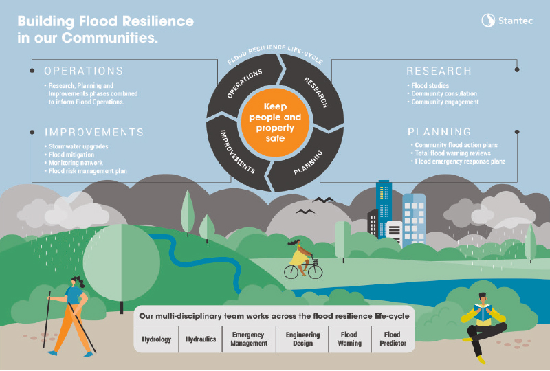
It is worth noting that although ultimate responsibility lies with local authorities and the relevant state and territory governments, to achieve true success, collaboration across the entire community is required. This collaborative approach is consistent with the Total Flood Warning System concept, which is part of the Australian Institute for Disaster Resilience Handbook Collection.2
The widespread major flooding that has been recorded over recent years provides the sector with new and valuable information that could be leveraged to define or review flood classifications across all jurisdictions. To do this effectively, it is critical that a standard approach is followed. While some jurisdictions have attempted to put rigour around this process (Queensland Reconstruction Authority provides a best-practice guide3) this is not available everywhere.
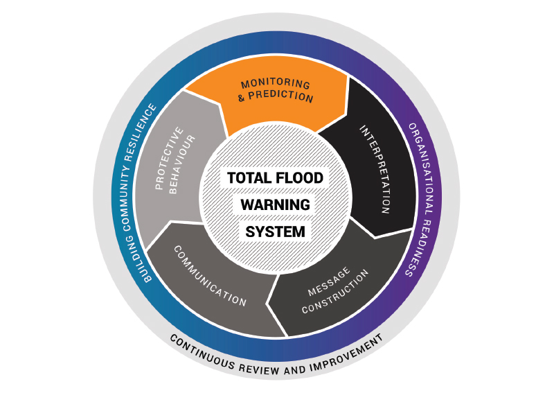
Figure 1: Total Flood Warning System
Source: Australian Institute for Disaster Resilience
The most important step in any flood classification review or development process should be negotiations with the Bureau to ensure it is aware of the intent of the review and to be given the opportunity to support any review. Once contact has been made with the Bureau, it is important to collate all available historical and contextual data, which would include items like:
- asset databases including elevation information to understand potential local infrastructure impacts from flooding
- historical data from rainfall and water level stations
- local knowledge or flood marks
- historical records in libraries or community groups.
In the absence of historical flood information or significant time passage since flood events, using recently completed flood risk modelling from a flood study can play a valuable role in understanding potential flood hazard.
The process of assessing flood risk through modelling typically begins with a review of available flood studies, flood emergency preparedness plans and flood emergency action plans that are available. Once this data collection phase is completed, a ‘representative zone of impact’ is determined with reference to a nearby water-level station. Following this zoning phase, fit-for-purpose criteria interpretating local conditions and available data is established against the Bureau’s flood classification definitions. The final step is a thorough spatial analysis of effects within the streamflow gauge’s zone of impact against the initial criteria to define the classifications and the risk.
Although using flood risk modelling is an effective method in the absence of historical or contextual information, flood classifications defined primarily from this method should be treated as provisional until a flood event is recorded. A full review and update process should be conducted shortly after to ascertain the accuracy of the provisional classifications.
Once all available historical, anecdotal and flood risk modelling information has been collated, the most effective way to propose where appropriate levels should be set is to prepare a list of local effects (from the collated information) and document levels at which flooding occurred to a consistent datum relative to the local gauge. These effects will range from very frequent small events that only produce minor inconveniencing consequences up to record flood events where large areas and properties are inundated.
Once this list is mapped relative to gauge height, reviewers define points in the list that are consistent with the effects expected to align to qualitative definitions of flood classification (minor, moderate or major). These qualitative definitions are the nationally consistent definitions for flood classifications from the National Arrangements for Flood Forecasting and Warning Services (see following).
Minor flooding
Causes inconvenience. Low-lying areas next to watercourses are inundated. Minor roads may be closed and low-level bridges submerged. In urban areas inundation may affect some backyards and buildings below the flood level as well as bicycle and pedestrian paths. In rural areas removal of stock and equipment may be required.
Moderate flooding
In addition to the minor impacts, the area of inundation is more substantial. Main traffic routes may be affected. Some buildings may be affected above the floor level. Evacuation of flood-affected areas may be required. In rural areas remove of stock and equipment will likely be required.
Major flooding
In addition to the minor and moderate impacts, extensive rural areas and/or urban areas are inundated. Many buildings may be affected above the flood level. Properties and towns are likely to be isolated and major rail and traffic routes closed. Evacuation of flood-affected areas may be required. Utility services may be impacted.
Once the new or reviewed flood classifications have been determined, the draft outcomes need to be reviewed by the Bureau before operationalisation can occur. Requests for flood classification changes follow a detailed process and to assist with this, the authority preparing the request needs to show the newly determined flood classifications in a way that gives the Bureau confidence and context as to why the classifications have been set.
Producing a ‘totem pole’ plot (see Figure 2) shows all relevant information (local effects, historical flood peaks, design flood levels and proposed flood classifications). This knowledge assists to justify the flood classification request and, once established, the totem pole can be referenced in future flood events by responding agencies. In addition to these operational benefits, totem poles can also be used to inform communities and help people understand what may occur when flood levels rise in their local area.
Once the request for a flood classification has been submitted, the Bureau will seek endorsement of the proposed change from the jurisdiction Flood Warning Consultative Committee. Once this endorsement is received, the changes are planned and operationalised by the Bureau via updates to the relevant regional Service Level Specification document and various systems, internal guides and the Bureau’s website. This process can take time and organisational effort to complete. This underscores the priority of engaging with the Bureau early in the process to ensure involvement can be planned and resourced.
Having flood classifications set correctly ensures timely and accurate information is provided to the community to keep people and property safe. For this reason, it is just as important to ensure that a location that doesn’t have significant flood exposure has its flood classifications removed. This removal ensures appropriate focus and effort can be placed on the locations of greatest need and no erosion of trust and credibility in the flood warning service occurs.

Figure 2: Flood classification totem pole
Reviewing flood classifications can take time and effort to complete effectively, but this activity should be viewed as an operational priority and is a required part of communities being as resilient as possible. Flood classifications are the foundation of flood forecasting and warning that the Bureau provides and they should be referenced in local disaster management plans and processes as well as in community-based plans.
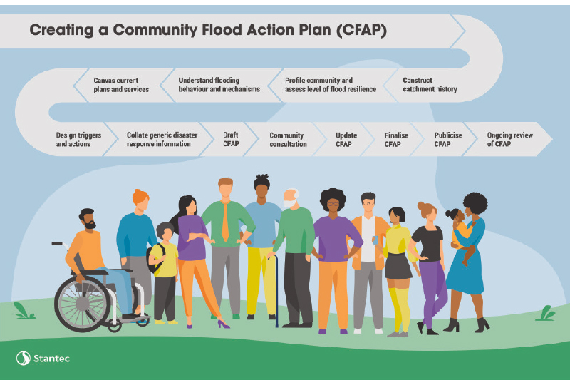
A Community-Based Flood Action Plan uses local understanding of flood effects, plain language and issuing criteria from local, state and territory and national authorities to provide easy-to-understand triggers and actions for people to respond before, during and after flood events. These triggers might include the overflow of floodwater over a bridge upstream, the release of water from a dam or the issue of a flood warning from the Bureau. When these triggers are activated, communities have a predetermined corresponding action to carry out.
To learn from recent prolonged and devastating flooding in Australia, we need to listen, collaborate and ensure that outcomes are holistic and fit-for-purpose. The focus needs to be on building resilient and robust infrastructure as well as on resilient communities. If done effectively, reviewing a region’s flood classifications is a great way to bring members of a community together with a shared goal of preparation and resilience to future flooding.