Climate projections indicate increasing frequency of intense rainfall events across Australia, even in regions where the average rainfall is planned to decrease or stay the same. When these events are rapidly unfolding, informing and warning communities are often the only, and therefore most important, actions local disaster coordinators can take. This paper shares insights from the City of Gold Coast as it sought to improve its community warning systems over time. Key innovations included establishing preformatted flood warning areas with automated threshold-based warnings and deployment of an opt-in alerts system that reached 60,000 subscribers. These enhanced systems provided near real-time warning capability during flooding events during December 2024 and reduced the manual intervention required as well as improved message consistency. This model demonstrated effective local government adoption of public information and warnings systems and allows transferable lessons for other jurisdictions. Success factors include multi-agency collaboration, community-centred design and integration of automated systems with human oversight.
Introduction
Severe weather events pose increasing challenges to Australian communities, with climate change projecting more frequent intense rainfall events even in regions where average precipitation may decrease (Bureau of Meteorology and CSIRO 2024). Such rapid-onset events challenge those responsible for local emergency and disaster management where timely, relevant and consistent community warnings are often the primary protective action available during the critical early phases of a response. Following major events such as the Black Saturday bushfires in 2009 and the Queensland floods in 2011 and 2022, the emergency management sector in Australia has undergone significant evolution. Each event has highlighted the critical importance of effective community warning systems while revealing persistent challenges for local government capabilities (Inspector-General of Emergency Management 2022). These challenges are particularly acute for metropolitan areas with diverse geography, multiple catchments and significant transient populations.
This report is a case study of the evolution of the emergency warning system at the City of Gold Coast (Council) between 2017 and 2025. This analysis examined how a large local government systematically addressed warning system limitations through technological innovation, multi-agency collaboration and community-centred design approaches. This study contributes to understanding local government emergency and disaster management capabilities and offers transferable lessons for similar jurisdictions facing rapid-onset hazard challenges.
Background
The Gold Coast in Queensland is a major tourist destination with a population of over 750,000 people (projected to exceed 1 million by 2046) and has over 12 million visitors each year (State of Queensland 2023). This coastal area has a diverse landscape including 80kms of rivers and streams, 774 hectares of lakes, dams and canals and 70km of coastline that has some of the most popular beaches in Australia (City of Gold Coast 2025c). While the city has a subtropical climate, it also has a long history of tropical cyclones, East Coast lows and other rapid-onset severe weather. These events have resulted in significant loss of life, infrastructure damage, economic affects, community disruption and environmental deterioration.
Under the Disaster Management Act 2003 (Qld)1, local government authorities, including the Council, are required to have a disaster management plan that ‘ensures the community is aware of ways of mitigating adverse effects of an event, and preparing for, responding to and recovering from a disaster’ (Queensland Government 2003, p.40). Accordingly, in 2018 the Council developed the City of Gold Coast Disaster and Emergency Dashboard (henceforth referred to as ‘dashboard’), which is a public information and warning online platform (City of Gold Coast 2025a). While the dashboard provided public information and warnings, there was a need for this information to be better timed and locally relevant.
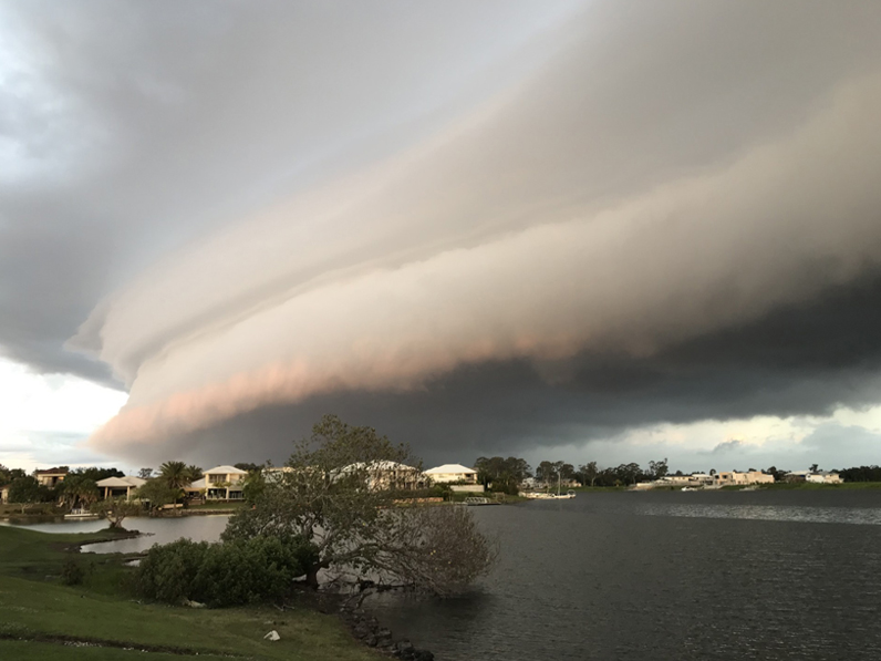
A severe storm approaches the Gold Coast residential areas in October 2022.
Image: David Youssef
2017: Cyclone Debbie
In 2017, Ex-Tropical Cyclone Debbie triggered heavy rainfall of over 600mm in 24 hours in some areas of the Gold Coast and caused extensive damage to infrastructure and homes, with significant flooding in both the northern and southern parts of the city (MacKenzie 2017). Warnings were issued and it was evident that the community accessed the dashboard, but there was room for improvement. A review of the system by MacKenzie (2017) highlighted the need to enhance publicly available information during adverse events. As a result of this review, the city’s Disaster and Emergency Management Unit was tasked with enhancing the emergency warning system.
Staff were confronted with numerous challenges, particularly given the city size, community diversity and the region’s complex riverine catchments.
These challenges raised questions:
- Relevance of public information and warnings:
- How can we make sense of the situation at the local level in numerous locations simultaneously?
- Which local factors, such as catchment characteristics and tidal movements, should be considered?
- How can we leverage geolocation to produce community mapping that includes potential flood extents, potential and actual flooded roads and relief centre locations?
- How can we provide locally relevant flood levels including water levels (minor, moderate and major flood levels, road levels, etc.)?
- Consistency in public information and warnings:
- How should we draft timely, relevant and tailored messages including calls to action and advice (with partner agencies)?
- In what way should we consult with adjoining local government areas to achieve message consistency and avoid community confusion?
- How can we ensure consistency in messaging when sending Australian Warning System-compliant messages, SMS and, if necessary, emergency alerts and publishing to both the Queensland Government warning website and local government dashboard?
- Timeliness in public information and warnings:
- How can we achieve detailed specialist analysis of rainfall forecasts?
- How can we ensure quick analysis of live rainfall and river gauge data?
- When should we send messages for maximum effectiveness
- When should we achieve necessary approvals to send warnings?
- How can we make sure to acknowledge that state-based warning system resources are finite and should be focused on areas perceived to have the greatest need of the warnings?
- How can we achieve all the above across multiple catchments and communities simultaneously?
2018: Introducing the Flood Intelligence System
In 2018, the Disaster and Emergency Management Unit made improvements to the dashboard taking into consideration the identified challenges. These included better access to flood-hazard information including types of flooding across the city, adopting Bureau of Meteorology educational materials and establishing flood gauge classifications (see Figure 1). While these improvements were a step in the right direction, they still did not allow for timely and locally relevant warnings. To add this would require technical enhancements as well as training to enable staff in the Local Disaster Coordination Centre to adequately interpret data from the rainfall and river gauges network in order to draft warnings.
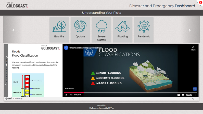
Figure 1: The Gold Coast disaster and emergency dashboard was improved and updated in 2018.
City of Gold Coast (2025a)
Two pilot projects were rolled out during the year. The first aimed to help staff understand and interpret the incoming data, especially in terms of interpreting data from the rainfall and river gauges network. A Flood Intelligence System module was also integrated into the council’s Incident Management System (see Figure 2).
The second aimed to enhance the timeliness of public warnings. The Flood Intelligence System allowed for flood warnings to be issued to the public via the dashboard, social media platforms and, where thresholds were met, emergency alerts. The system became the first line of intelligence and operated 24 hours a day, 7 days a week to alert the Disaster and Emergency Management Duty Officer and decision-makers when river or rainfall triggers were met.
Upon receiving an alert, the Local Disaster Coordination Centre may be activated and flood modelling specialists may be tasked to conduct detailed flood modelling through advanced technology (known as the Flood Emergency Decision Support System). The analysis is fed back to the Local Disaster Coordination Centre that decides whether to issue a public warning. A key enabler of the Flood Intelligence System is the river and rainfall radio telemetry network. The network provides access to over 100 rainfall and river gauges and means monitoring occurs in the background 24 hours a day. While not addressing all the challenges listed the Flood Intelligence System and the work implementing it, was a large step in the right direction.
2022: Severe weather event
Over February and March 2022, another rainfall event classed as an ‘extreme multi-day rainfall causing significant flooding’ by the Inspector-General of Emergency Management, hit southeast Queensland, including the Gold Coast (Inspector-General of Emergency Management 2022, p.12). Warnings were issued throughout this event through many different channels including ‘Emergency Alerts, the Bureau of Meteorology weather warnings, opt-in systems, social media, radio and television’ (Inspector-General of Emergency Management 2022, p.13). These warnings varied significantly in their timeliness, consistency and relevance and some communities did not receive the warnings.
Following this event, members of some affected communities said that they felt information provided did not adequately prepare them for the rapid-onset nature of the event, particularly in relation to residential over-floor flooding (i.e. the height of the flood level). A review conducted by the Inspector-General recommended that ‘all local governments [should] offer an opt-in system and develop strategies to increase the number of subscribers who elect to use this service’ (Inspector-General of Emergency Management 2022, p.77). These outcomes and recommendations deepened the Council’s commitment to improve its public warning capabilities.
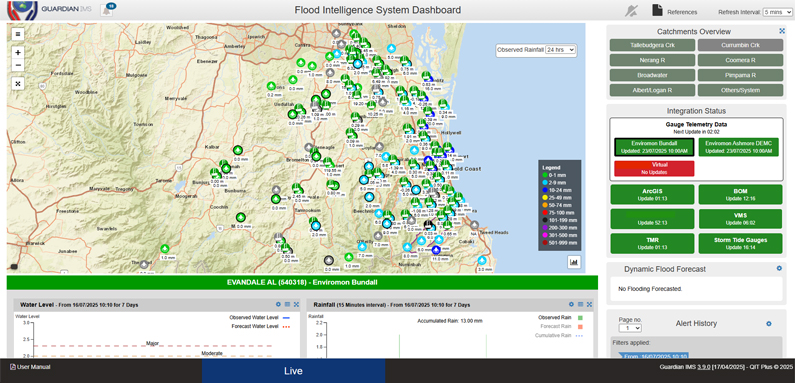
Figure 2: A Flood Intelligence System was incorporated into the Incident Management System.
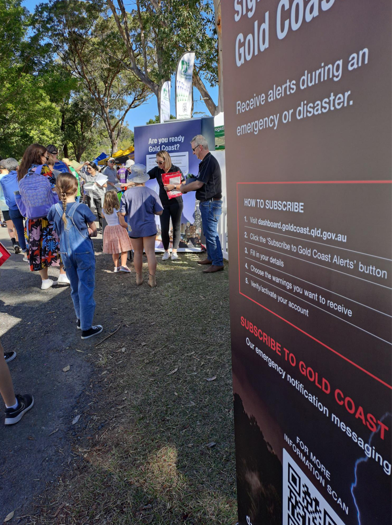
2022: Launching opt-in messaging - GC Alerts
In August 2022, the Council launched GC Alerts. This is a free service allowing people to sign up for direct SMS and email notifications of potential hazards. Signing up involved filling out a registration form on the Gold Coast Dashboard (see Figure 3).
The information used to issue GC Alerts is sourced from the Bureau of Meteorology, the Flood Emergency Decision Support System, the Flood Intelligence System and staff analysis; all of which contribute to timely flood warning. For example, local river and rainfall gauge information is fed to the Incident Management System, which can then directly notify decision-makers on the potential need to release a warning product through GC Alerts.
As part of the Get Ready Queensland2 initiative to increase community awareness about how to prepare for extreme weather events, an educational campaign was launched to encourage the community to subscribe to GC Alerts. This is an going campaign both in face-to-face and digital engagement. Opt-in messaging is another step to provide timely, accurate and relevant emergency alerts for people in the City of Gold Coast.
2023: The Australian Warning System
In 2022, an extreme weather event raised issues that were explored by the Inspector-General who found:
…there are constraints of the Emergency Alert system and the telecommunications infrastructure it relies on… There appears to be a general lack of awareness by local governments regarding the emergency alerts system’s constraints’ particularly when multiple local governments are requesting warnings at the same time.
(Inspector-General of Emergency Management 2022, p.64)
Alerting and warning the community, it appeared, was not only about the timeliness and local relevance but also was a tight alignment with national warning systems to ensure consistent messaging.
In 2019, research by Metrix (2019) assessed community perceptions of existing warning systems and identified potential improvements that could make warnings clearer and increase potential for people to take action during hazard events. More than 14,000 people across Australia were surveyed or interviewed and inputs were gathered from multiple Australian emergency services and hazard agencies.
Informed by this research, work commenced on an Australian Warning System, which was aimed at standardising warning messages across Australia. The system was implemented in Queensland in November 2023. During that year, all warning products issued by the city via the dashboard, GC Alerts and social media complied with the new national standards.
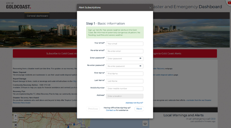
Figure 3: Dashboard sign up form.
Source: City of Gold Coast (2025a)
2024: Developing preformatted flood warning areas
Aside from opt-in messaging and alignment between national and local emergency alerts, the Inspector-General recommended:
…that all local governments that do not have preformatted messages and polygons engage with Queensland Fire and Emergency Services and determine whether their Local Disaster Management Group capability could be improved through the development of preformatted polygons and messages.
(Inspector-General of Emergency Management 2022, p.15)
In line with this recommendation, the Local Disaster Management Group established a working group comprising of the City of Gold Coast, State Emergency Services, Queensland Fire Department, Queensland Police Service, the Department of Transport and Main Roads as well as internal business units of the council to identify communities at risk of flooding and establish preformatted polygons called Flood Warning Areas. Additional advice was sought from the State Disaster Coordination Centre Warnings Unit, QIT Plus (incident management system vendor) and other subject matter experts as needed. Over a 6-month period commencing in September 2024, 6 flood warning area workshops were conducted.
The purpose of the flood warning areas was twofold. First, pre-established flood warning areas can help community identify potential hazards. For example, information about heights of local roads can help people understand how their area might be affected during a flood and helps them to prepare accordingly. Second, and most importantly, flood warning areas improved the Disaster Management and Emergency Unit’s ability to warn the community rapidly during severe weather events through GC Alerts and the dashboard.
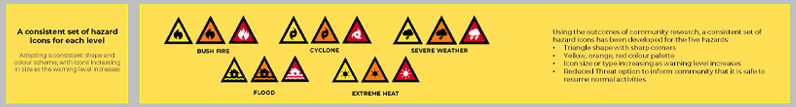
Australian Warning System icons.
Source: AIDR website, www.australianwarningsystem.com.au
Setting these up involved integrating the Flood Intelligence System with the Bureau of Meteorology’s local classifications of minor, moderate and major flooding to establish flood warning areas (Bureau of Meteorology 2013) (see Figure 4). Work included incorporating an Australian Warning System-compliant message, for example, by warning against driving into flooded areas and providing guidance on safe evacuation routes. While moderate and major flooding events may not occur in a resident’s lifetime, the flood warning areas and associated warnings are available to help community members make the best-informed decisions to prepare for or act during an extreme weather event. In addition, flood warning areas include properties, not necessarily to indicate a direct risk of flooding, but to suggest that some roads in the area could be affected. It is important to note that, based on risk analysis and factors including topography, many properties may not need to be included in warning areas. This information allows community members to develop their own emergency plans suited to their circumstances and location.
Community information events raised awareness about the updated warning system.
Image: Fannie Couture
Several criteria were used to establish flood warning areas:
- The risk of a community or infrastructure at risk of flooding
- A local river gauge with current flood classification (minor, moderate or major)
- Pre-determined flood model results and extents based on specific rain scenarios
- Advice from the working group.
The flood warning areas and associated Australian Warning System templates were developed in consultation with working group members and were based on discussions and analysis of the following:
- existing model results based on specific rain intensity scenarios
- emergency management factors
- the collective knowledge of each government department and agency as to previous events, risk and best practice advice to the community.
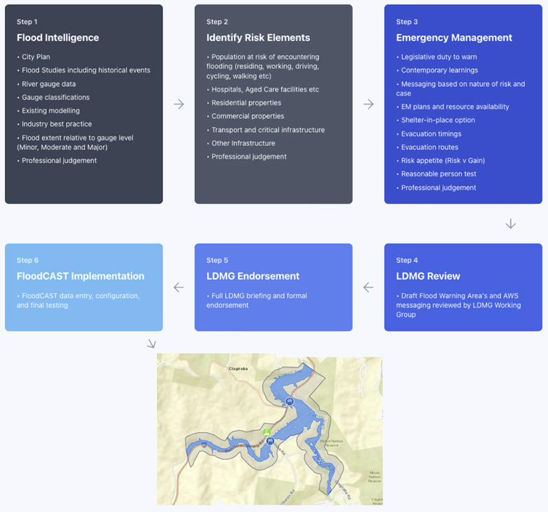
Figure 4: Flood warning areas methodology.
Source: City of Gold Coast
While the flood analysis and warning processes were technically advanced, they required staffing or remote support. The Flood Warning Areas allowed for an automated first step to warning the community. These changes were deployed and formed the basis of warnings provided during the New Year's Day flooding event in 2024.
2023–24: A windy, wet and hot Christmas and New Year
On 25 December 2023, a severe weather event developed in southeast Queensland that greatly affected the Gold Coast. There were destructive winds peaking at 160km/h, 53mm of rain, frequent lightning and large hailstones that caused widespread damage to homes, businesses and infrastructure. The powerful winds resulted in significant effects, including a fatality, community isolation, fallen trees and power lines, damaged roofs and buildings, widespread electricity outages and disrupted communications. From 28–30 December, the region endured a 3-day low-intensity heatwave with temperatures climbing to 40°C and elevated humidity levels. Many Gold Coast residents and businesses experienced power outages and communication difficulties during this period. Another round of severe storms hit on 1 January 2024, bringing damaging winds and torrential rain. Some areas recorded over 500mm of rain, leading to additional flooding and property damage across the region.
During this event, the council was building the next version of GC Alerts incorporating the flood warning areas. A dashboard test environment was under review (not public facing) and showed that 3 locations would have been identified at the minor and moderate flooding levels and would have initiated automatic warnings to GC Alerts subscribers in near real-time. This automated system subsequently replaced the former method that involved the Disaster and Emergency Management Duty Officer drawing a manual polygon and issuing the warning by inserting relevant details to that catchment. This method took, at best, 20 minutes and was particularly challenging due to a Duty Officer being required to undertake other activities including briefing the Local Disaster Coordinator.
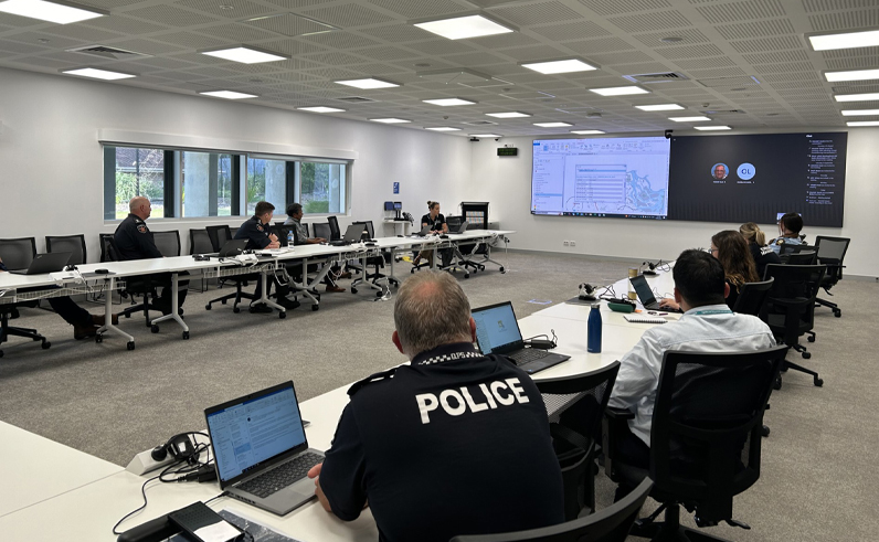
Flood Warning Areas Multi-Stakeholder Working Group meeting in September 2024.
Image: David Youssef
2025: Integrating warning innovations in GC Alerts and dashboard
Encouraged by early results, further enhancements were implemented in February 2025 to strengthen the Council’s ability to provide timely, relevant and consistent information during severe weather events. The enhancements were:
- integration of preformatted polygons - formal integration of local flood warning areas into the dashboard
- storage of preformatted Australian Warning System messaging - storing of pre-drafted warning messages for each Flood Warning Area, which are compliant with the Australian Warning System
- linking the Flood Intelligence System to Flood Warning Areas - providing 24/7 monitoring of the river and rainfall gauges across the city, to enable issuing of warnings relating to specific flood warning areas
- interactive map in messaging - facilitating near real-time alerts and information that allows subscribers to geolocate themselves on an interactive map, determine if they are in a warning area and provide them clear directions in line with the Australian Warning System on actions they should consider taking
- interactive dashboard - the dashboard was enhanced to include effective messaging and to feature an interactive community warning map (platform) to deliver near real-time warnings and advice to the community.
2025: Tropical Cyclone Alfred
In March 2025, the newly integrated emergency warning system was put to the test with Tropical Cyclone Alfred. The cyclone had wind gusts of up to 107km per hour, heavy rainfall with some regions receiving more than 1,000mm of rain. Around 140,000 households were without power. Throughout the event, 16 emergency alerts and 30 GC Alerts were issued (via email/SMS) totalling 1.18 million SMS messages sent in what was considered timely, accurate and consistent. GC Alerts resulted in a 400% increase in subscribers from 16,000 before the event to almost 60,000 one week after the event. The dashboard received 3.21 million views and 50,000 site visitors downloaded the City of Gold Coast app. Feedback during and after the event was majority positive on the relevance and timeliness of warnings. The Council successfully became the single point of truth for the community in a time of deep uncertainty and when the need for consistent, timely, accurate and relevant information was needed.
The future
The Council has a clear purpose in providing timely, relevant and consistent emergency warnings. While the integrated system developed and described here was based on 5 flood warning areas, a total of 20 flood warning areas have been established and this information shared with the community via the dashboard (City of Gold Coast 2025b). In the longer term, it is anticipated that more than 30 flood warning areas encompassing up to 40% of the Gold Coast region will be established.
While these enhancements are an important step in the provision of emergency warnings, as technology advances, further improvements will be achieved. The analysis of ‘big data’, machine learning and rapid developments in AI will facilitate greater real-time predictive capability that can improve warnings and community safety. Flood warning areas are expected to change over time based on factors such as urban development and insights gained from rainfall events.
Acknowledgment
This work was financially supported by the Canadian Social Sciences and Humanities Research Council, number #430-2024-00044.