Introduction
In 2011, a severe earthquake and tsunami in Tōhoku in northern Japan was a stark reminder of the devastating power of natural hazards. The magnitude 9.1 earthquake and the resulting tsunami caused widespread destruction, claiming nearly 20,000 lives and displacing hundreds of thousands of people (NOAA 2021; National Geographic Society 2025). The Tohoku event was a reminder of the critical importance of preparedness, understanding of the hazard and effective evacuation planning in mitigating the effects of catastrophic events.
In 2015, the United Nations declared World Tsunami Awareness Day (held on 5 November each year) to raise tsunami awareness and share innovative approaches to risk reduction. With the 15th anniversary of the tragedy occurring on 11 March 2026, it is timely to recognise the advances made by disaster management groups in Queensland to understand and address the state’s tsunami risks; efforts exemplified by the work undertaken in the Gladstone Regional Council area through the project ‘Tsunami risk assessment for the Gladstone Regional Area’ (the Gladstone tsunami project).
The Tsunami Guide for Queensland (Queensland Fire and Emergency Services 2024) notes that southern Queensland is more likely to experience higher levels of tsunami hazard (based on offshore wave height) than other parts of the state’s coastline. The area from Agnes Waters to Yeppoon (including Gladstone) is identified as one of the top 10 most hazardous locations in Queensland. The Gladstone tsunami project under the Australian Government Coastal and Estuarine Risk Mitigation Program was developed and has delivered robust inundation modelling to inform the development of evacuation planning for the Gladstone region.
Tsunami evacuation zones in Queensland1 were determined following national guidance that used a heuristic approach to identify areas less than 10 metres above sea level and within 1 kilometre from the coast that are at risk of inundation (AIDR 2025). While this method provided a conservative baseline for evacuation planning, recent studies suggest it may overestimate the areas at risk in parts of Australia (Kendall et al. 2024). The detailed modelling developed through the project, supplements the current heuristic evacuation mapping to provide greater insights into areas of potential inundation, including critical infrastructure such as the Gladstone port facilities.
Strong, collaborative relationships between agencies, local governments and community partners are fundamental to Queensland's disaster management arrangements,2 underpinning the coordinated and flexible approach to effective preparedness, response and recovery. The project was a collaborative effort between several select organisations, each contributing expertise and resources, brought together under a Project Advisory Group.
The Queensland Fire Department worked closely with Geoscience Australia, which provided advanced modelling and technical expertise as well experience with similar studies in Western Australia3 and New South Wales.4 The Gladstone Regional Council played a vital role by integrating local knowledge and developing evacuation mapping and planning. The modelling relies on high-quality onshore and offshore elevation data and tide gauge data that was provided by the Department of Environment, Tourism, Science and Innovation and Gladstone Port Corporation. Other partners in the project group included the Queensland Police Service; the Queensland Reconstruction Authority; Gladstone Ports Corporation; Mutual Aid Group Gladstone and the Department of Environment, Tourism, Science and Innovation.
The project focused on tsunamis generated by earthquakes along major Pacific Ocean subduction zones, which are the most common sources of tsunami threats in the region. The modelling provided a detailed understanding of potential inundation zones under various tsunami scenarios. The results were designed to align with the Joint Australian Tsunami Warning Centre (JATWC) warning categories5 to maximise practical application for emergency responses.
The findings of this project are particularly significant for the Gladstone region due to its critical port infrastructure and low-lying areas that are exposed to coastal inundation. By integrating local knowledge with the results of the modelling, emergency services planners, local governments and disaster management groups can establish effective tsunami evacuation zones, preparedness and response strategies. This initiative enhances community safety and also strengthens the region’s resilience to future tsunami events. Recognising the diverse sources of tsunami risk, the Australian Tsunami Advisory Group subsequently initiated the Understanding tsunami risk to Australia from volcanic sources project with Natural Hazards Research Australia, which aims to address knowledge gaps by developing scenarios to assess the onshore tsunami risk posed by volcanic activity in the south-west Pacific, south-east Indian and north-east southern Oceanic regions.
2024 Tsunami Guide for Queensland (Queensland Fire and Emergency Services 2024)
Inundation modelling
The methodology used to developed detailed tsunami inundation hazard information was an integration of scientific expertise and advanced computational techniques, building off successful applications in Western Australia and New South Wales. The inundation modelling addressed the limitations of traditional heuristic methods, by providing a more precise and actionable understanding of the tsunami hazard for the region.
At the core of the project was a Probabilistic Tsunami Hazard Assessment (PTHA), a framework to combine the hazard from multiple tsunami scenarios. Scenarios were selected from Geoscience Australia’s PTHA18 database (see Davies 2018) of earthquake-generated tsunamis from major subduction zones. For each scenario used in this framework, a hydrodynamic solver was designed for the Gladstone region to simulate tsunami wave propagation. The modelling used nested grids to refine the resolution in areas of interest to ensure that the results were accurate (by validation with observed events in the region) and relevant to local conditions. As an example, Figure 1 displays nested grids at different levels of resolution as green, yellow and orange boxes for modelled maximum water levels generated by the 2007 Solomon Islands tsunami event.
A key feature of the methodology was the use of Monte Carlo techniques (Davies et al. 2022) to approximate tsunami inundation hazards across a broad spectrum of scenarios. This approach allowed computational limitations associated with directly modelling all possible scenarios to be overcome. By sampling hundreds of earthquake-tsunami events, the Monte Carlo method provided robust statistical insights into the likelihood and extent of inundation for different scenarios informing the warning categories issued by the JATWC, including No Threat, Marine Warning and Land Warning. These warning categories were used to define model-derived inundation zones, which serve as the foundation for evacuation planning.
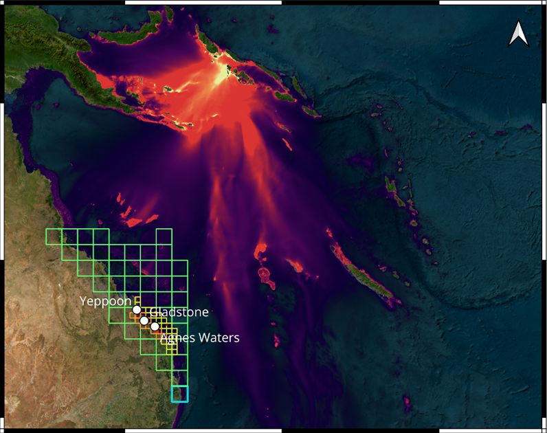
Figure 1: Modelled maximum water level for the Solomon Islands 2007 tsunami with nested grids used in the Gladstone project.
Source: Macaulay and Davies (2025)
A comparison between the inundation modelling and current evacuation mapping (based on the heuristic approach) showed a potentially larger designation of evacuation zones than may be necessary (see Figure 2, which displays a comparison between inundation modelling and evacuation mapping based on the traditional heuristic evacuation zones). While the current heuristic ensures a conservative approach, it can result in unnecessary evacuations and place undue stress on communities and emergency services organisations. While the modelling cannot identify which scenario(s) will eventuate, it incorporates conservative assumptions such as using a high tide and merging inundation footprints from multiple scenarios to allow for precise evacuation zones and to reduce overall disruption to communities.
The probabilistic methodology used for the inundation modelling is regarded as best practice in tsunami hazard modelling with a similar method used in New Zealand. This is the first time it has been implemented in Queensland. By applying lessons learnt from other jurisdictions, this project set a new benchmark for tsunami risk assessment in Queensland.
Exercise Capricorn Surge
Exercise Capricorn Surge was conducted 30 July 2025 by the Gladstone Local Disaster Management Group at Gladstone to assess the application of modelling outputs and inform tsunami response strategies. Participating agencies included Gladstone Regional Council, Queensland Fire Department, Queensland Police Service and Gladstone Ports Corporation. The discussion-based exercise simulated a high-impact tsunami scenario triggered by a large undersea earthquake in the South West Pacific Ocean. The exercise generated discussion on the unique challenges posed by such low-probability high-consequence events with limited warning time.
The exercise had 6 objectives:
- Understanding tsunami warning products and escalation triggers.
- Clarifying roles and responsibilities among agencies.
- Applying tsunami modelling to inform response decisions.
- Assessing risks to vulnerable communities and critical infrastructure.
- Developing public information and warning strategies.
- Exploring early recovery and transition planning.
As the exercise unfolded, participants engaged in dynamic discussions and decision-making processes. The modelling from Geoscience Australia provided detailed insights into potential inundation areas and helped participants to assess evacuation zones and identify critical infrastructure at risk. This data-driven approach meant response strategies devised were based on scientific evidence to improve effectiveness of the exercise.
One of the most pressing challenges highlighted during the exercise was the short arrival time of the simulated tsunami. This reinforced the importance of having accurate and timely evacuation plans in place that were already tailored to the geographical and industrial characteristics of the local region. Participants reviewed and refined these plans to improve future implementation in a real-world setting. The exercise provided opportunities to revise public information and community warning approaches to focus on the need for clear, consistent messaging and effective coordination across agencies.
At the conclusion of the exercise, recommendations were developed to address the challenges identified and enhance the region’s response and recovery arrangements. Recommendations included refining evacuation mapping, improving public warning systems and integrating tsunami response actions into evacuation and road operations plans. The exercise showed the importance of continuous re-evaluation and improvement so that emergency management plans remain effective and responsive.
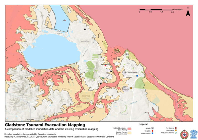
Figure 2: Comparison between inundation modelling and current evacuation mapping.
Conclusion
The 2011 Tohoku earthquake and tsunami was a reminder of the significant effects of low-probability and high-consequence disasters such as tsunamis. This project reviewed the proactive actions taken by key state organisations to manage tsunami risk in the Gladstone region. By supplementing an heurestic approach approach with advanced inundation modelling, this project provided a detailed and actionable understanding of tsunami hazard. The integration of scientific expertise, local knowledge and stakeholder input means that the region’s evacuation planning is accurate and practical. Exercise Capricorn Surge operationally tested modelling outputs and allowed stakeholders to identify and address critical challenges, such as the short warning times associated with tsunamis and the protection of critical infrastructure. The exercise also generated actionable recommendations to enhance disaster preparedness and response for the Gladstone region.