Abstract
April 1990 was a month of severe flooding in eastern Australia. Two months later, a national workshop was held in which a large number of flood management specialists sought to capture the lessons of the floods while they were still fresh. Many aspects of the management of the events were examined, with flood warning highlighted as a key function. A second meeting the following year resolved to produce a best-practice manual to help guide practitioners in the development of flood warning services. The term ‘Total Flood Warning System’ (TFWS) was adopted to describe the need to integrate the many elements of effective warning. The need to help those in the path of a flood to understand the warnings they received and take effective action was recognised as central. The manual was published in 1995 and revised and updated in 1999 and 2009. This paper asks what has changed and improved in the flood warning field since 1990 and what is needed in TFWS terms to further help communities and individuals manage their flood risk.
Recent history of flood warning in Australia
What might be called the ‘modern era’ of flood warning in Australia can be considered to have started during the 1960s (McKay & Robinson 2012). Then, the Bureau of Meteorology (BoM) began to use hydrological modelling in a limited number of river valleys to produce flood forecasts.1 Telephone and, later, computer telemetry was used to improve BoM access to the growing number of rain and river gauges. Over time, the number of locations around the country for which flood warning services were provided increased. Locally-defined ‘minor, moderate and major’ flood levels were adopted for specified gauges as a means for creating a general understanding of how severe an approaching flood would be in areas close to the gauges. These were often called the ‘reference areas’ of the gauges.
By the late 1980s, the BoM had established a flood warning presence in each state and the Northern Territory. The warning service had become more or less standard in conceptualisation, content and format. Forecasts were provided in the most part by the BoM with alternative arrangements in the Northern Territory and the Melbourne metropolitan area. Warning messages included the expected class of flooding (in many but not all cases with a forecast peak height and time) at the nominated gauge and included observed water (gauge) levels along the watercourse. Peak forecasts were often made only after upstream peaks had been observed. Messages were sent to radio and television stations broadcasting into the regions expected to experience flooding and to local council and emergency services organisations within those regions.
The personnel of these responder organisations made decisions about what they and community members should do, but there was little consistency of practice. In most areas the information in the BoM warnings lacked the necessary detail to allow much to be inferred or said about the probable consequences of the coming flood. As a result it was not always possible for responder agency personnel and communities to develop a clear picture of where the water would go, what depths would be reached, which people would be affected and what they should do to lessen the coming impacts.
This problem, exacerbated by a tendency for the agencies to emphasise organisational priorities (e.g. resupply, sandbagging, rescue, evacuation operations, etc) rather than those of community members as clients, limited the value of the warnings that were provided.
At the end of the 1980s it appears, in general, that there was considerable distance between the BoM forecasters and the emergency responders. The two groups did not speak the same language and nor had they reached a common understanding of the purposes of flood warning. Flood warning had not developed to a high level of sophistication and its methods and practices were in need of evaluation and reform. This was especially so in the context of recognising community members as end users with an interest in being able to protect their own interests as floods approached. Critically, too, the lack of information (‘flood intelligence’) to ‘unlock’ the meaning of a flood prediction in areas facing floods limited the utility of warnings.
Some very serious floods were soon to occur. These floods were to give flood warning practitioners real opportunities to push their craft to higher levels of utility to people who live and work in locations prone to flooding. The floods across eastern Australia in April 1990 were to prove critical.
Reform of Australian flood warning practice: the early 1990s
April 1990 saw severe floods in the three eastern mainland states of Australia. Flood height records were broken and there was much community devastation and loss. The inland areas of Queensland and New South Wales were especially hard hit and large areas were inundated or cut off from the outside world. The towns of Charleville and Nyngan had to be evacuated virtually in their entirety. Nyngan’s levees were overtopped despite desperate community efforts to augment them with tens of thousands of sandbags. Nearly all the town’s dwellings took in water and 18 helicopters had to be organised to take the town’s almost 2500 people to safety. At the same time Charleville (approximate population 3000) was swamped by the Warrego River and about 80 per cent of its houses along with most of the industrial and commercial premises were flooded. Almost the entire population was evacuated and housed temporarily in a large tent city at the local airport. Then intense rain over Victoria’s high country caused flooding along several Gippsland rivers, and many people had to leave their homes with attendant damage to property and agricultural assets and production (BoM 1992).
The occurrence of such severe flooding affecting many communities at once and necessitating large- scale relief operations and costly recovery measures, led to a national, multi-agency debrief to tease out the lessons learnt and to consider appropriate future community responses. A four-day workshop was held at the then Australian Counter Disaster College (later the Australian Emergency Management Institute) at Mt Macedon, Victoria. It was attended by BoM weather and flood forecasting specialists, representatives from the emergency services (principally state and territory emergency services and police), employees of state water and community services agencies, local government representatives, academics with expertise in floodplain management and individuals from media organisations. More than 50 people attended the workshop with all Australian states and territories represented.
The multi-agency nature of the attendance was significant. In April 1990, as had been the case in some areas since the BoM began providing flood forecasts, flood warning activity was largely confined to BoM flood predictions with emergency services organisations (encompassing the State Emergency Services, police and local government officials) delivering on a limited role in motivating community responses to predicted coming floodwaters. However, by late 1989 the BoM had taken steps to increase the input of the emergency services and state water agencies to flood prediction processes. It did this by creating state-based Flood Warning Consultative Committees (FWCCs) under the chairmanship of the BoM’s respective regional directors. The role of the FWCCs was to advise the BoM on how to make improvements to the provision of its flood forecasting services. Many of the attendees at the Mt Macedon workshop were drawn from the various FWCCs. In retrospect, the formation of the FWCCs and the holding of the workshop constituted the beginning of genuine, multi-agency participation in flood warning in Australia. The two initiatives were to be catalysts for the codification of the principles of flood warning and the identification of better ways of generating and delivering warnings to communities about to be hit by floods.
The workshop considered a range of matters including:
- the nature of the weather systems that had caused the flooding
- the efforts that had been made to warn communities about it
- the management of the large-scale evacuations that had been undertaken
- what had been done to organise the welfare and engineering aspects of the recoveries in the three states
- the flood responses of the three states (by way of comparison)
- the strengths and weaknesses of what had been done
- ways of improving management.
Participants agreed that flood warning procedures and practices in particular needed further examination.
Accordingly, a second workshop was scheduled for October 1991 with a similar attendance to the meeting of 1990. It was at this workshop that a new term, the Total Flood Warning System, came into vogue. It captured the developing consensus that if flood warning was to genuinely help communities facing floods, the involvement of several agencies was required with their inputs coordinated and integrated. Flood warning could not, it was agreed, be effective if it was to remain largely the province of the BoM. The BoM’s involvement was seen to be critical but not by itself sufficient.
A recognition developed that flood warnings needed to be ‘value-added’ in terms of the likely consequences of impending floods and how people in their paths should react. It was also recognised that the BoM, a scientifically based forecasting agency, could not be expected to add that kind of information to the level of detail required. More input was needed from emergency services and other locally based organisations with interests and personnel located in or close to the communities targeted by the warnings. Those entities had, or had the means to develop (through detailed flood studies and with the help of floodplain management consultants) the flood intelligence (information on what would happen at different gauge heights as a flood rose towards its peak) essential to enable communities to understand the intent and purpose of flood warning messages. Figure 1 illustrates the relationships.
Further, it was recognised that not only were flood warning messages limited in content but that they were not generally capable of ‘breaking through’ to people’s consciousness or instilling a sense of the need to act with positive action (e.g. to protect items of property or evacuate to safety). Information needed to be communicated more effectively to flood-prone communities. Both the content and the style of the messaging required re-thinking, and the use of a wider range of dissemination techniques considered. The tone of messages was seen to be vital in motivating appropriate responses on the part of individuals whose interests were under threat.
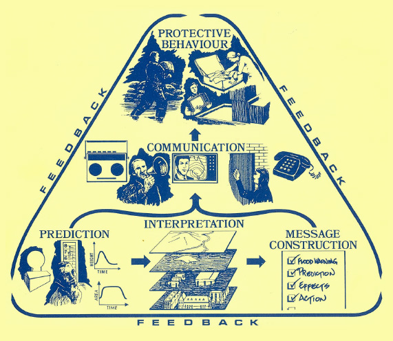
Figure 1: Total Flood Warning System relationships (AEMI 1995).
This second workshop decided that a core need was a guide to best practice in the field of flood warning. A manual defining best practice and giving guidance on how it could be achieved by involved entities was proposed. The resulting document, Flood Warning: an Australian Guide, was published 1995 (AEMI 1995, also Keys et al. 1995). Later that year, small workshops were conducted in states and territories to familiarise local practitioners with its contents.
The manual focused on five questions, answers to each were provided in some detail:
- How far will the water reach at the nominated gauge, and when?
- Where will the water go at the predicted height?
- Who will be affected by the flooding, and in what ways?
- What do these people need in order to respond effectively?
- How can those people best be given the appropriate information?
The manual created a modern conceptualisation of flood warning processes and to codify them. It focused on flood height prediction, the use of flood intelligence to help determine where the water would go at forecast heights, who would be affected by it and in what ways, what those people needed to know and how to communicate with them in ways that would motivate appropriate response behaviours. In doing these things it emphasised the multi-agency character of the warning task and the need for the integration of the activities of specialists in different agencies. Most importantly, it widened the scope of the task beyond the BoM’s traditional forecasting role.
Reviews and updates to the manual and to better practice
No manual of practice in any field is fit for purpose indefinitely. Manuals can only incorporate current knowledge and ideas about the functions discussed. They are therefore creatures of their time.
Best practice in flood warning is an evolutionary process as for all endeavours. New ideas are formed and adopted and management practices improved. Examples include:
- recognition that attention to information and messaging is critical (ANZEMC 2014)
- development of rain and flood forecasting techniques
- adoption of new ideas on flood predictions (e.g. clearly defining the areas to which forecasts apply)
- improvements in the dissemination of warning messages
- making use of specialist floodplain management consultants to provide flood intelligence on the impacts of flooding. While the latter was not something routinely sought decades ago, it is increasingly well recognised that it should be a routine deliverable from flood and related.
Not long after publication of the original flood warning manual, it became clear that there was a need to provide an updated product for flood warning practitioners. Updated versions of the manual were published in 1999 and 2009 (EMA 2009a) with the revision task carried out by panels made up of specialists from various fields and organisations. A companion manual on flood preparedness incorporated material about how to engage with communities in an educative manner (EMA 2009b).
In the not too distant future, a further update of the flood warning manual will be required in order to document the latest shift in good (best) flood warning practices and how more recent lessons have been translated into improved practices.
It should be noted here that there have been some technical advances in flood warning practice in recent times, not all of them noted in the manuals. These include provision by the BoM, on request from State Emergency Services of ensemble forecasts in the lead- up to significant flooding events, the extension of flood watches to the whole of Australia and other internal developments aimed at streamlining the BoM’s internal forecast process.
Lessons and the ongoing challenge
Forecasting
Ideas are changing in relation to good practice for flood forecasting. Two or three decades ago, a good flood prediction was considered one which accurately forecast, with some lead time, the peak and the time that peak was reached. Nowadays, this is often considered to be insufficient. With access to increasingly detailed flood intelligence, it is obvious that the peak is not the whole and often not even the main story. Consider the situation of a rapid initial rise in river level followed by a slower one as the flood approaches its peak. If the important consequences occur early in the period of the rise, the time taken to reach the peak may be largely irrelevant because the necessary response actions will have had to be undertaken well in advance of the peak being reached. Should the forecast not be released until the rapid rise has begun, opportunity to undertake the relevant actions will have been lost. Moreover the degree of precision in the peak forecast will be of small importance and the forecast will have little value.
The learning is clear. A forecast and time to achieve critical levels associated with key consequences, on both the rising and falling limb of the flood hydrograph, when provided with adequate lead time, is important, useful and informative to an at-risk community. A warning that includes the forecast hydrograph (rather than just an interim or peak height and time) has significant utility to an informed community and the emergency services that support it.
Similarly, a move to the delivery of ensemble flood forecasts (wherein imprecision associated with translating a point measurement of rainfall to an area and the subsequent flood forecasting process is translated through to the predicted hydrograph) adds additional value. It is desirable that the uncertainty inherent in a flood forecast is communicated to those at risk as it informs decisions about likely consequence and appropriate responses.
Linking the forecast with the need
It is suggested that what should guide the forecaster is the usefulness of the prediction across the full hydrograph, not the precision of a point on that hydrograph and the technical rigour of the analysis. It follows that the response agency needs to ensure that the forecasting agency understands what flood levels are critical in terms of actions on the floodplain. One way of achieving that understanding is via the specification, at community level, of forecasting requirements including the amount of time needed by community members and responder agencies to carry out necessary tasks some of which, such as evacuation, will often take many hours. This can only be done beneficially using clear knowledge of the heights, at the relevant gauge, at which important flood effects occur. Floodplain management consultants can be used more than has so far been the case to provide information on probable consequences, within the reference areas of gauges, at different gauge heights.
How it will be interpreted
Even so, having established a specification, it must be known and followed by all agencies. Stories from Lismore in March 2017 (e.g. Gissing & Leeuwen 2017) when ex- Tropical Cyclone Debbie was about to produce severe flooding, suggest that a warning of impending flooding over a recently constructed levee was provided too late. The order to evacuate from the central business district and its immediate surrounds was implemented too early. The consequence was that people were unable to protect stock and records in shops and offices and items of value in dwellings. A clear understanding of how the various TFWS elements fit together is essential across all involved entities, including the at-risk community, if intended benefits are to be delivered.
Linkages and the importance of timing
Flood warning messages should indicate how much time is available for property-protecting tasks before evacuation becomes necessary. They must also counter the tendency for people in the path of a flood to delay their responses until they can see the floodwaters. Too often potential response time is lost and responses are less effective than they should be.
Pre-scripted warning messages
A NSW SES initiative related to the preparation of pre- scripted warning messages to be broadcast via media outlets for different forecast heights. This was promoted in the 2009 version of the manual. It was recognised that under the operational stresses of floods the preparation of such messages in the real time of an event rarely achieved optimal standards of communication and frequently failed to motivate effective responses within communities. Important information was missed and the language used was clumsy. Better results could be achieved if, in ‘planning time’, messages were created and stored ready for use when floods were actually developing. For a particular gauge for which flood forecasts were to be provided by the BoM, messages could be prepared for a number of increments in height (say from the threshold of minor flooding up to beyond the level reached by the flood of record). ‘Banks’ of messages could be developed, critiqued and fine-tuned to ensure that likely consequences and needed response actions were incorporated and appropriate tones (for example in terms of urgency) were used. The intent was that the pre-prepared messages could be used on the day with added information specific to the developing event.
Understanding flood risk and warnings
Warnings, it must be recognised, are unlikely to motivate appropriate responses from community members unless the flood problem is understood by the people in the communities to which the warning messages are targeted. In a sense warning of floods should be treated, like flooding itself, as a hazard that people need to prepare for and helped to comprehend in advance. This is particularly the case in communities for which levees and other structural means of flood mitigation have been provided. These measures can be highly effective in keeping out quite large floods, but this effectiveness has the result of reducing flood experience among community members and thus their consciousness of the flood problem. In essence levees in particular become more trusted than they should be. As mitigative devices virtually never eliminate the flood problem (and can also be subject to failure), an antidote to the downside they generate (the notion that the problem has been fully overcome) is needed if community resilience against floods is to be maintained. Most importantly, warning messages need to note specifically when overtopping or failure has become possible and indicate that urgent responses (usually including evacuation) will be needed.
Flood intelligence
Flood intelligence is central to the TFWS. Developing and collating this information through comprehensive flood studies, sharing it with the at-risk community (e.g. as maps or tables), updating it based on actual experience and using it to drive forecast delivery is fundamental to establishing a user- and risk-focused service that is driven in a bottom-up manner. In turn that assists in building flood resilience within the community. Risk and need must drive forecast scope, delivery and location.
Communication
None of this means that warnings provided must be perfect in predicting flood severity, gauge heights or every potential consequence. It does mean that they must provide warning information that people understand. They must also provide it in ways and within timeframes that will motivate people to act in ways that will protect their interests. Many messages simply do not get through. Witness, for example, the frequency with which people drive into or otherwise enter floodwaters, too often with tragic consequences (Haynes et al. 2016), despite the campaigns featuring the messages ‘If it’s flooded, forget it’, and ‘You don’t know what you’re getting into’. Clearly, the educational messages are not working optimally, which means they must be re- evaluated rather than being repeated. When more than half of the flood deaths in Australia since the turn of the 21st century have been caused by people entering floodwaters, mostly in motor vehicles, the efforts to educate can be lacking (Gissing 2017). In this regard it is not sufficient simply to explain the deaths as examples of people’s stupidity.
Flood education
Flood education in Australia, generally, remains not fully developed. Too often, people fail to react to floodwater until they see it near their properties, by which time it may be too late for effective responses to be implemented. What has been done has been demonstrated to be inadequate and many people with interests on floodplains remain largely ignorant of the risk they face. This is an area that needs further consideration and development. Education workshops attract little interest, but providing people with critical (for them) flood heights at a nearby gauge merits attention. This has been tried only very rarely and is worth trialling.
The role and influence of social media
Social media and the internet are playing an increasingly large and changing role in our lives. How we communicate risk and the consequences of flooding and how we disseminate warnings and related information must have regard for how communities communicate, how they share information, their trusted sources and how these change. This is not a static environment. Agility and adaptability are essential.
Sometimes the processes of communication go awry, partly because of misunderstandings about the relationship between a flood warning and the relevant information for an area in the path of the expected flooding. Two examples illustrate this problem, which is quite commonly experienced. In June 2007, as a flood approached Maitland, in the NSW Hunter Valley, local responders built a sandbag levee to protect the central business district, which had not been flooded in much bigger events than the one forecast on this occasion (Keys 2008, p. 96). Effort was wasted on unnecessary activity and the credibility of the response was damaged. A similar lack of understanding of the flood risk was apparent in Horsham, Victoria, in June 2011 where, again, a line of sandbags was built in an area with no risk of flooding (as was indicated in flood extent maps that had been shared with the community). Sandbags were wasted, undue pressure was placed on emergency services agencies and many people who needed sandbags missed out (Mintern, Aziz & Fennell 2017).
Consultation and review
The potential for the FWCCs to make a difference and provide a focus for the development of the multi-agency and risk (or user) based approach to TFWS development is huge but as yet not fully realised.
Recent public reviews of significant flood events and by extension performance of the TFWS provide further evidence of lessons learnt (e.g. Comrie 2011, QFCI 2012, Blake 2017). The authors have resisted pulling these reports apart and translating the findings for this paper. Regardless, the next update of the flood warning manual must have regard for commentary, community and agency feedback and recommendations embedded in
these reports.
Conclusion
Flood warning services today are a significant step forward from where they were in early 1990. The improvement journey is, however, far from over. There remain examples where best practice has not been consciously sought (e.g. Keys & Cawood 2009).
There is an unfortunate truth about flood warning in Australia: for example, it has not yet lived up to its potential to counter loss in the way that levee-building has. Virtually every significant flood sees damage done to communities (including injuries and deaths as well as property losses) that could have been avoided had people heeded the warnings that were provided or had the warnings been better tailored to suit the risk in terms of focus, content and messaging. At least part of the reason is that the agencies involved in forecasting and warning of coming floods have not fully engaged with the communities that their activities are intended to help. The consequence is that the forecasts and warning messages provided are not sufficiently relevant and community members have not understood what has been provided to them. Perhaps, too, recent reviews of flood management practice have given less attention to warning as a flood management tool than ought to have been the case.
Since the first flood warning manual was published there have been concerns that the take-up of the manuals has been disappointing. To the extent that this concern is valid it can be argued that the recommendations have not altered agency forecasting and warning practices to the desired extent. For example, forecasts do not necessarily respond to risk and need and response agencies have not, in most cases, developed suites of pre-scripted messages. Nor have they all developed strong educational programs to help people become aware of the risk from flood or of the nature and purpose of flood warning and the behaviours they need to undertake upon hearing a warning as a flood is approaching. What is probably needed is a national workshop of key emergency services personnel to re-familiarise them with the recommendations of the current manual and help them to come to grips with implementing those recommendations.
Footnotes
- Flood forecasting is an important component of flood warning, where the distinction between the two is that the outcome of flood forecasting is a set of forecast time-profiles of channel flows or river levels at various locations, while flood warning is the task of making use of these forecasts to tell people about coming floods (American Meteorological Society 2017).