Given New Zealand’s susceptibility to a range of natural hazards, reducing exposure is an important step towards strengthening community resilience and reducing potential social, environmental and economic consequences. Land-use planning has long been recognised as a contributor to achieving this goal. Focusing on earthquake hazards, this paper examines the evolution of risk reduction measures in local government land-use planning documents for 3 earthquake-prone regions of New Zealand in 2000 and again in 2016. While some progress has been made in planning for earthquake hazards, overall the planning documents in these regions remain inadequate. As such, resilience from a land-use planning perspective has not significantly improved. This is surprising in the context of major seismic events in New Zealand over the last decade that have caused considerable damage and loss of life. Future anticipated changes to the planning systems in the country provide opportunities for improvements to be included in documentation.
Introduction
New Zealand’s tectonic setting
New Zealand is a long and narrow island nation that lies on the Pacific Ring of Fire, which makes it particularly susceptible to earthquakes. Approximately 90% of the world’s earthquakes and 81% of the largest earthquakes occur in this tectonic zone (Jang et al. 2016). Over 15,000 earthquakes are recorded across New Zealand every year, although, on average, only 100–150 are strong enough to be felt (GNS Science n.d). Figure 1 shows the geographic variation of earthquake hazard across New Zealand as represented in the 2010 National Seismic Hazard Model.
The Hikurangi Subduction Zone lies offshore to the east of the North Island and has the potential to generate magnitude 9 earthquakes and tsunami similar to the Great East Japan earthquake in 2011 (Power 2013). An Alpine Fault earthquake is also regarded as a future event of significance (Orchiston et al. 2018) and a large number of other known and unknown faults present threats (Stirling et al. 2012). Recent large earthquakes in New Zealand include the February 2011 earthquake in Christchurch that claimed 185 lives (Potter et al. 2015), the 2013 Cook Strait/Seddon earthquakes (Doyle et al. 2018) and the 2016 Kaikōura earthquake that struck the upper South Island and lower North Island (Stevenson et al. 2017). It is vital that New Zealand be as prepared as possible for future earthquake events. It is not a question of if another will occur, but when.
The vital role of land-use planning
Reducing risks from earthquakes can occur via land-use planning, engineering of buildings and other infrastructure and preparedness initiatives. The vital role of land-use planning in avoiding and mitigating natural hazards such as earthquakes is well recognised, as it allows a mechanism by which to control the use and development of land areas identified as susceptible to the effects of earthquakes (Burby 1998, Berke & Smith 2009, Glavovic, Saunders & Becker 2010, Saunders & Becker 2015). The Sendai Framework for Disaster Risk Reduction 2015-2030 (UNISDR 2015) of which New Zealand is a signatory, highlights governance and risk reduction as priorities to improve resilience (Priority 2 and 3). Land-use planning is a key component of this.
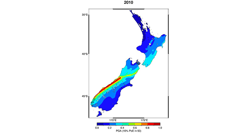
Figure 1: New Zealand's earthquake hazard based on the 2010 National Seismic Hazard Model showing Peak Ground Acceleration for 10% probability of exceedance in 50 years.
Source: GN Science
As noted in Brody (2003), a high-quality land-use plan consists of 3 equal components:
- a strong factual basis
- clearly identified goals
- appropriate supporting policies.
A land-use plan that successfully integrates these factors is important to avoid or mitigate the effects of natural hazards (Brody 2003).
Land-use plans evolve over time in response to changing community needs, advances in scientific knowledge and learnings from experience of events (Brody 2003). While a number of studies have evaluated the quality of land-use plans for managing natural hazards within discrete timeframes (Berke et al. 1999, Berke & Godschalk 2009, Lyles, Berke & Smith 2014), longitudinal analyses of planning for natural hazard mitigation are scarce in the literature. This study examined patterns of change in 24 land-use planning documents gathered from 3 earthquake-prone regions in 2000 and in 2016. The aim was to examine the evolving nature of disaster risk reduction approaches in local government land-use plans over time, with a focus on earthquake hazards (e.g. fault rupture, ground shaking, liquefaction). Of interest was whether the 2016 analysis would reflect heightened awareness prompted by the 2010–2012 Canterbury Earthquake Sequence that included the devastating 2011 Christchurch earthquake. This highlighted planning issues for hazards such as fault rupture and liquefaction (Saunders & Becker 2015).
Overview of legislation to manage natural hazards
Resource Management Act 1991
While natural hazards are managed in New Zealand under a number of pieces of legislation (see Glavovic, Saunders & Becker 2010, Saunders et al. 2020) the Resource Management Act 1991 (RMA) is New Zealand’s principal environmental planning statute and provides the framework for land-use planning decision-making. The purpose of the RMA is to ‘promote the sustainable management of natural and physical resources’ by ‘managing the use, development, and protection of natural and physical resources in a way, or at a rate, which enables people and communities to provide for their social, economic, and cultural wellbeing and for their health and safety’ (Resource Management Act 1991). With respect to hazards, the overall focus of the RMA is an ‘all hazards’ approach rather than being earthquake-specific; similar to other legislation (e.g. the Civil Defence Emergency Management Act 2002).
Governance is divided between central and local governments. Local government is further separated into 2 tiers, comprised of 11 regional councils and 61 city or district councils with city and district councils collectively referred to as ‘territorial authorities’. In addition, there are 6 unitary authorities that are territorial authorities with regional council responsibilities. Regional council boundaries generally follow water catchment boundaries, while territorial boundaries are defined by identifying communities of interest. This has meant that, in some cases, territorial authority districts lie across more than one region.
The RMA makes regional councils responsible for controlling the use of land to avoid or mitigate natural hazards. Regional Policy Statements are key documents in meeting this requirement as they identify the significant resource management issues for the region and the objectives, policies and methods (but not rules) to address them. The 67 territorial and unitary authorities (referred to collectively as ‘local authorities’) are responsible for the avoidance or mitigation of natural hazards by controlling the effects of the use of land. This is achieved by District Plans that identify local issues (including natural hazards) and set out the objectives, policies, methods and (unlike Regional Policy Statements) rules to address them, all of which are generally supported by assessment criteria. Regional Plans and District Plans must give effect to the relevant Regional Policy Statements and District Plans must be consistent with Regional Plans (plural since some local authorities straddle more than one region). Under this structure, District Plans play a vital role in avoiding or mitigating the adverse effects of natural hazards at a local community level by controlling the subdivision, use and development of land. Planning provisions in Regional Policy Statements, Regional Plans and District Plans (collectively referred to as ‘land-use plans’) are required under the RMA to be reviewed every 10 years.
The RMA does not prescribe how to manage natural hazards. This is in keeping with the principles of devolved power and effects-based management that is largely devolved and left to the discretion of the territorial authority affected. This is providing that the overarching purpose of the RMA is met, namely, the sustainable management of natural and physical resources (Berke et al. 1999, Glavovic, Saunders & Becker 2010, Saunders & Glassey 2007). Thus, local authorities and communities have to understand, identify and manage their own risks. This means that a community’s exposure and vulnerability to natural hazard risk could reduce or increase over time in response to its interpretation of the RMA. Equally, adjacent communities (that face similar levels of exposure) could have vastly different levels of resilience and vulnerability depending on their approach to managing natural hazards.
Local resilience measures of authorities influence the resilience and sustainability of adjoining districts and regions as the effects of natural hazard events have no regard for boundaries. This influence works through authorities' input into ‘broad resource networks through connections with suppliers and other key stakeholders of [their] environment’ which organisations access (Branicki, Steyer & Sullivan-Taylor 2016, p.1267). Such organisations include those in neighbouring communities as well as national organisations. This can be a blessing or a curse, depending on whether local authorities do a good job or a poor one. In reality, as Glavovic, Saunders and Becker (2010, p.682) note:
…in the absence of a recent threat or event, more immediate concerns tend to dominate the public agenda. Taking proactive measures to reduce hazard risks is thus accorded a low priority, and it seems as if communities simply hope that “it won’t happen to them”.
Thus, not only are hazards a threat, but vulnerability (and also exposure by location of people, systems and assets) is at risk of being worsened by reactive planning or wishful non-planning and the devolution to local authorities can exacerbate risks.
Changes to the Resource Management Act 1991
A number of changes have occurred to the RMA that relate to hazard planning. Amendments in 2017 elevated the management of significant risks from natural hazards to the national level. Concern over the overall effectiveness of the RMA has led to a resource management review (Resource Management Review Panel 2020) that recommended the development of 3 pieces of new legislation:
- a Natural and Built Environments Act (NBA)
- a Strategic Planning Act
- a Climate Change Adaptation Act.
An Exposure Draft of the NBA bill was released in mid-2021 for consultation (Natural and Built Environments Bill 2021). The NBA Exposure Draft includes environmental outcomes that require targeted risk reduction for natural hazards and climate change, and improvements in resilience and their effects (Part 2, Section 8(p)). A national planning framework is required to set provisions for natural hazards and climate change (Part 3, Section 13(1)i), and these should be implemented in regional plans and spatial strategies (Part 3, Section 15(1)).
Another change under the NBA is mandatory plans for each region, which would reduce the large number of policy statements and plans that currently exist to just 14. These changes are not reflected in this study as data was collected before the changes to the RMA and the release of the Exposure Draft, but are considerations for the future of hazards planning.
Other relevant legislation and guidance
The Building Act 2004 also plays a role in managing natural hazard risk at a local-government level and is legislation that includes earthquake-specific provisions. The Act requires that territorial authorities “must refuse to grant a building consent for the construction of a building or major alterations…if the building work is likely to accelerate, worsen, or result in a natural hazard on that land or any other property”. (Building Act 2004). This does not apply, however, if they consider adequate mitigation measures taken. To comply with the Building Code regulations under the Act, residential buildings must be constructed to withstand a future earthquake with a one in 500-year return period of shaking, while critical facilities such as hospitals must be designed to withstand a one in 2,500-year event. An amendment to the Act in 2016 introduced specific measures that require the strengthening of buildings identified as earthquake-prone in response to the 2010–2012 Canterbury earthquakes (Filippova & Noy 2020).
Also important is the role of the Civil Defence Emergency Management Act 2002 in avoiding or mitigating the adverse effects of natural hazards. Plans prepared under this Act are designed to inform and integrate with RMA plans (Saunders et al. 2007) and provide a stronger directive towards achieving the resilience goals of the Sendai Framework for Disaster Risk Reduction 2015-2030. In addition, the National Disaster Resilience Strategy that came into effect in 2019 provides guidance on the vision and goals for resilience in New Zealand (Ministry of Civil Defence and Emergency Management 2019).
Several guidance documents assist with land-use planning for earthquakes including ‘Planning for the Development of Land on or Close to Active Faults guidelines’ (Active Fault Guidelines) (Kerr et al. 2003), ‘Planning and engineering guidance for potentially liquefaction-prone land’ (Ministry of Business, Innovation and Employment 2017) and general natural hazards planning guidance on the Quality Planning website (Quality Planning 2017). While not mandatory, these guidelines help land-use planners when making decisions. No single national policy statement on natural hazards has been issued in New Zealand via the RMA that compulsorily directs local government on how to plan for natural hazards.
Method
To examine the changing nature of local government policies and plans for the reduction of earthquake hazard risk, an earlier study of policies and plans conducted by Becker and Johnston (2000) was replicated. The original study was a document analysis of 24 planning documents (3 Regional Policy Statements and 21 District Plans or City Plans) from Hawke’s Bay, Bay of Plenty and Waikato regions in New Zealand (Figure 2). The analysis was conducted to understand how land-use planning documents covered earthquake hazards.
For context, Hawke’s Bay Region is highly exposed to the effects of subduction earthquakes from the Hikurangi Subduction Zone approximately 150 kilometres east offshore, as well as other local faults. The Bay of Plenty Region encompasses the Taupō Volcanic Zone and is an area of high earthquake hazard due to numerous faults caused by active crustal extension and volcanism (Stirling et al. 2000, 2012). The southern and eastern districts of the Waikato Region lie within the Taupō Volcanic Zone, however, the remainder of the region is considered less prone to earthquake hazard (Becker & Johnston 2002).
Table 1 lists the districts and regions whose policy statements or plans were examined in 2000 and again in 2016. As some district boundaries straddle more than one regional boundary (e.g. Taupō and Rotorua), the 2000 authors allocated these districts to a single region.

Figure 2: Location of Hawke's Bay, Bay of Plenty and Waikato regions and districts.
Source: Becker & Johnston 2000
Table 1: List of regions and districts examined in 2000 and again in 2016.
| Region | District |
| Hawke’s Bay Region | Napier City Hastings District Wairoa District Central Hawke’s Bay District |
| Bay of Plenty Region | Ōpōtiki District Tauranga District Western Bay of Plenty District Kawerau District Whakatāne District Rotorua District |
| Waikato Region | Ōtorohonga District South Waikato District Waikato District Franklin District* Waitomo District Hamilton City Thames-Coromandel District Hauraki District Waipa District Matamata-Piako District Taupō District |
* In 2010, the Franklin District was abolished and divided between the Auckland, Waikato and Hauraki councils. The Franklin District Plan continues to be administered by the Hauraki District Council. Including that plan there were 24 documents examined in 2016.
Due to the requirements of the RMA for land-use plans to be reviewed and updated at least every 10 years, all the District Plans and Regional Policy Statements examined in Becker and Johnston (2000) had been reviewed by the time the study was undertaken in 2016. The same set of 34 questions used to examine the original dataset in 2000 was applied to the revised planning documents in 2016 (Table 2). These questions were developed to reflect what was considered best-practice planning in the literature (see Becker & Johnston 2000, 2002). Questions sought to identify whether the planning documents included:
- hazard- and earthquake-focused definitions
- objectives
- policies
- methods (including rules)
- assessment criteria and performance standards
- reference to relevant building legislation
- limitations and use of emergent information
- earthquake-related environmental outcomes
- earthquakes on planning maps.
The 24 documents were reviewed and, for each question, were coded ‘yes’ or ‘no’ as an answer.
The 2016 data was triangulated with a secondary data source collected after the 2010–2012 Canterbury Earthquake Sequence by Saunders and Ruske (2014). This study involved an exhaustive examination of 99 regional policy statements, territorial authority plans and Civil Defence Emergency Management Group plans. Where the district and regional planning documents still represented the latest documents created by the authorities, their data were re-interrogated for the 2016 study using the same 34 questions.
The collection of the 2016 data, in combination with the data from Saunders and Ruske (2014), allowed a longitudinal comparison with the original 2000 study to determine whether earthquake hazard and risk reduction measures had been better integrated into land-use planning documents over time.
Table 2: Questions used to analyse earthquake inclusion in local authority policy statements and plans in 2000 and 2016.
| Part of the plan or policy statement | Document review questions |
| Inclusion of a natural hazards chapter/section | Does the plan/policy statement:
|
| Hazard and earthquake definitions | Does the plan/policy statement:
|
| Objectives |
Does the plan/policy statement have:
|
| Policies |
Does the plan/policy statement have:
|
| Methods |
Does the plan or policy statement have:
|
| Assessment criteria |
Does the plan/policy statement have:
|
| Performance standards for earthquakes |
Are there any performance standards for earthquakes? |
| The Building Act 1991* |
Does the plan or policy statement refer to:
|
| Practicalities of planning for earthquakes |
Does the plan or policy statement:
|
| Earthquake hazard information |
Does the plan or policy statement:
|
| Environmental outcomes |
Does the plan/policy statement have:
|
| Hazards on planning maps |
Are local hazards included on planning maps? |
* When the Becker and Johnston (2000, 2002) study was conducted, the statute in force was the Building Act 1991, while the Building Act 2004 was in place for the 2016 data collection. The Building Act 1991 limits the construction of, or alterations to, buildings that might worsen certain natural hazards, similar to the 2004 Act version.
Limitations
Limitations of the research include that the data collected were primarily quantitative and that nuances in what is written in plans are not reported here. Data related to the implementation of the Sendai Framework for Disaster Risk Reduction 2015-2030 or the National Disaster Resilience Strategy were not collected as these documents had only just been finalised or not developed at the time of data collection.
Results
Table 3 provides the quantitative results of the longitudinal comparative analysis. This has been arranged to reflect the original lines of questioning and to allow for comparisons between the original data and updated data.
Table 3: Comparison of results from the original study (Becker & Johnston 2000) and new data collected in 2016.
| Theme from content analysis | Results from Becker and Johnston (2000, pp.9–14) | Results from 2016 data collection plus Saunders and Ruske (2014) | Change in percentages of total* |
| Structure of the plan or policy statement | ‘Most (92%) have a “hazards section”.’ | 83% have a section on natural hazards. | 9% decrease |
| The prevalence and nature of hazard definitions | ‘Only 33% of plans and policy statements include a definition of the term “hazard”.’ | 54% of plans and policy statements include a definition of a hazard. | 21% increase |
| ‘75% of councils note…that earthquakes are a hazard that could affect the district or region.’ | 88% of these documents listed earthquakes as a hazard. | 13% increase | |
| ‘One quarter briefly identify the location of major earthquake hazards, while three-quarters of councils make no mention of the location of earthquake hazards in their region or district.’ | A quarter identified the location of fault lines in the district or region. | 0% change | |
| ‘29% also make some attempt to describe the nature of earthquakes and document their potential physical and/or social affects. 71% of councils do not.’ | 29% of plans and policy documents describe earthquake hazards and their effects. | 0% change | |
| Objectives | ‘83% of councils’ plans or policy statements follow this [recommended ‘all hazards’] approach.’ | 96% of plans and policy documents are ‘all hazards’ based. | 13% increase |
| ‘Only one council has an objective specifically tailored for earthquakes in its plan.’ | Again, only one council had specific objectives for earthquakes. | 0% change | |
| Policies | ‘83% of policies in plans and policy statements can be described as ‘all hazard’.’ | 96% of policies can be described as ‘all hazard’. | 13% increase |
| ‘Earthquakes are mentioned specifically in three councils’ policies [13%].’ | Four policy documents (17%) have specific policies about earthquakes. | 4% increase | |
| Methods | ‘Methods in plans or policy statements are generally ‘all hazards’ based although some particular methods (for example, rules) mention earthquakes.’ | Two-thirds of methods are ‘all hazards’ based. | 33% decrease |
| Rules** | ‘Of the 21 district councils***, half have some rules in their plans that cover hazard issues in general.’ | 100% of District Plans have ‘all hazards’ rules. | 50% increase |
| ‘95% of those plans have some rules relating to specific hazards.’ | 100% have specific hazard rules, but not necessarily relating to earthquakes. | 5% increase | |
| ‘Of the 95% that have rules for specific hazards, two councils [10%]…have some specific rules regarding earthquakes.’ | 29% have specific rules for earthquakes or fault lines. | 19% increase | |
| Monitoring | ‘Fourteen councils [58%] take an “all hazards” approach [to the use of monitoring as a method to mitigate against hazards].’ | 42% commit to monitoring that is ‘all hazard’. | 16% decrease |
| ‘Earthquakes are specifically mentioned once regarding monitoring’ [4%]. | 13% of monitoring statements mention earthquakes. | 9% increase | |
| Assessment criteria | ‘17% of councils have some assessment criteria for natural hazards. Four councils take an ‘all hazards’ approach to the assessment criteria in their plans.’ | All 24 plans and policy statements (100%) include general hazard assessment criteria. | 83% increase |
| ‘Only one council (Taupō District Council) has any specific criteria regarding earthquakes.’ | Three councils (13%) have specific assessment criteria regarding earthquakes. | 9% increase | |
| Performance standards | ‘With regards to earthquakes, two district councils mention performance standards.’ | Three documents (13%) include performance standards for earthquakes. | 4% increase |
| Legislation | ‘Three-quarters of regional and district councils make reference to the Building Act [1991] with regard to hazards in general.’ | 71% of plans and policy statements refer to the Building Act [2004] regarding general hazards. | 4% decrease |
| ‘One-third…also makes a direct connection between the Building Act [1991] and planning for earthquakes. | 17% specifically reference the Building Act [2004] in relation to earthquakes. | 16% decrease | |
| Limitations and use of emergent information | ‘29% of councils note…that because of the nature of earthquakes, limitations of planning for earthquakes exist.’ | 29% of the sample noted the limitations and practicalities of planning for earthquakes. | 0% change |
| ‘One council [4%] states…that, due to the nature of earthquakes …avoidance or control is not realistically possible through the District Plan.’ | Five councils (21%) stated that planning for earthquakes is not possible through District Plans or Regional Policy Statements. | 17% increase | |
| Earthquake hazard information | ‘46% of district and regional councils acknowledge that there is a gap in the seismic information held by council and/or scientists and make provision in their plans or policy statements to attempt to gain further data.’ | 50% of plans and policy statements recognise that there is a need for the council to update the local seismic hazard information, and acknowledge that there is a lack of local information available. | 4% increase |
| ‘75% of council plans and policy statements have methods to account for and incorporate any new information that arises.’ | 33% of the documents account for new hazard information coming to light. | 42% decrease | |
| Environmental outcomes | ‘75% [of] plans and policy statements have [‘all hazards’] environmental outcomes.’ | 88% of the sample includes ‘all hazards’ based environmental outcomes. | 13% increase |
| ‘25% mention environmental outcomes related to specific hazards.’ | 50% have hazard-specific environmental outcomes. | 25% increase | |
| Planning maps | ‘A third of councils [33%] analysed included natural hazards on their planning maps.’ | 75% of the documents included local hazards on their planning maps. | 42% increase |
* Rounded. Changes are in percentages of all documents. Generally, one council = one document out of 24 = 4.2%. Franklin District Council had been disestablished but its document bundle still existed, administered by Hauraki District Council.
** Rules are only included in District Plans. Therefore percentages are based on 21 plans, not 24.
*** The term ‘district council’ in this table includes city councils.
While some improvements were seen, other aspects showed negative changes, or no change at all. Results of note include:
- the percentage of planning documents that identified areas subject to natural hazards on planning maps had risen by 42%; from roughly 33% to 75%
- the percentage of documents that recognise that earthquakes are a hazard that could affect the region or district had risen by 13%
- no change in the percentage of plans that identify the location of fault lines in the district or region; at 25%
- the percentage prevalence of ‘all hazard’ objectives, policies and (applicable for district/city councils only) rules, where ‘all hazard’ means there is no differentiation for earthquakes, had risen respectively by 13%, 13% and 50%
- no change in use of specific objectives for earthquakes (remaining at just one plan)
- the percentage use of earthquake-specific rules had risen by 19%
- the percentage of councils stating that planning for earthquakes is not possible through District Plans or Regional Policy Statements had risen by 17%
- the percentage of plans that specifically reference the Building Act in relation to managing earthquake risk had fallen by 16%
- the percentage of documents that have methods to account for and incorporate new hazard information had fallen by 42%.
Discussion
From the results of the original study, Becker and Johnston (2002, p.7) concluded that:
…while more hazard information and policies are incorporated into plans and policy statements than they were pre-Resource Management Act 1991, it appears that there is still not enough being done, with many councils undertaking the bare minimum to meet legislative requirements.
Lyles, Berke and Smith (2014) similarly concluded in their analysis of 175 local mitigation plans in the United States that the reflexive framework of the Disaster Mitigation Act 2000 (like the RMA) had meant that while local governments had met the requirement to adopt a plan, there was little evidence of going beyond the minimum national requirements in relation to the mitigation of natural hazards. Unfortunately, the results of this study reinforce these conclusions, showing only slight improvement over a long period beyond Becker and Johnston’s (2000) findings.
It was found that natural hazards, in general, are being better recognised and provided for in the 3 regions considered, with the percentage of plans that identified local hazards on planning maps rising by 42% and an increase was seen across ‘all hazards’ objectives, policies and rules. This approach helps to ensure that the actions taken (policies) to achieve the desired outcomes (objectives) are consistent regardless of what natural hazard is being considered (Saunders, Beban & Coomer 2014). The largest increase was in ‘all hazards’ rules with a maximum-possible rise of 50 to 100%. This is significant because while objectives and policies describe the desired outcomes of a plan and how this outcome is to be achieved, without supporting rules to control development in hazard-prone areas councils have little or no power to ensure the outcomes occur (Saunders, Beban & Coomer 2014).
Saunders, Beban and Coomer (2014) highlight some of the potential limitations of an ‘all hazards’ approach, including that a council may have insufficient information on the risk a particular hazard presents (e.g. earthquake or tsunami) to fulfil the stated objective. The council may be less driven to seek information and, if the objective is poorly constructed and open to interpretation, it may prevent the council from implementing effective risk reduction measures for all relevant natural hazards. Saunders, Beban and Coomer (2014) also identify the advantage of hazard-specific objectives that are supported by hazard-specific policies and provide a strong policy direction for the consideration of the effects of that hazard. When supported by hazard-specific rules and assessment criteria, land-use planners have a strong foundation for decision-making, which will result in improved community resilience over time.
While the number of earthquake-specific objectives remained static, it was encouraging to see a rise of 4% of plans with earthquake-specific policies and a rise of 19% use of earthquake-specific rules, to a total of 29%. This result is broadly consistent with the finding of Saunders, Beban and Coomer (2014) that 38% of all District Plans across New Zealand had specific rules pertaining to active faults. While enforcement of these rules leads to increased resilience of communities, Saunders et al. (2014, p.28) observed that ‘given the tectonic environment of New Zealand, this suggests that there is a large under-representation of active fault rules within the District Plans’. Indeed, while there was a rise of 13% of plans that recognised earthquakes as a hazard, the number of councils identifying the location of fault lines remained static at 25%. This suggests that the issue is a lack of information held by councils of the location of active faults rather than a lack of faults present in a region. Indeed, 50% of plans and policies in 2016 recognised the need to include more information. This is despite the presence of an easily accessible national Active Faults Database (Langridge et al. 2016).
Surprisingly, the percentage of councils that specified procedures for the inclusion of new information into land-use plans had dropped by 42% to less than half of its former number. As suggested by Saunders and co-authors (2015), it may be that the broader procedure for updating plans and policy statements is provided in the RMA and does not need to be repeated in local land-use plans and councils are, for some reason, relying on this. However, the risk of not detailing a specific process (e.g. that new information will be made available on the council website and planning maps before council undertakes a plan change in accordance with the RMA) is that councils are not compelled to incorporate new hazard information outside of the 10-yearly review. Thus, development in hazard-prone areas will continue (Saunders, Beban & Coomer 2014) and this will be difficult to undo later. As Glavovic, Saunders and Becker (2010, p.654) noted, there are a number of ‘burning issues’ which have needed addressing in land-use planning in New Zealand and the first of these was to ‘improve understanding about the nature of hazards’, a theme that is mirrored in Sendai Framework for Disaster Risk Reduction 2015-2030, Priority 1 (UNISDR 2015). However, while recent earthquake events have contributed to scientific understanding of earthquake hazards in New Zealand, Kilvington and Saunders (2016) found that availability of hazard information within local government is not sufficient alone to ensure its incorporation into council decision-making processes. Councils might hold new or updated information, but may wait to incorporate it into the next plan review cycle. In this context, the results are not so surprising.
As identified by Glavovic, Saunders and Becker (2010), another need is to prioritise risk avoidance (reduction) measures. Land-use planning is a key tool to reduce exposure and vulnerability to earthquakes by establishing fault avoidance zones, limiting critical infrastructure and facilities in locations adjacent to faults and ensuring other earthquake hazards such as liquefaction, tsunami and landslides are considered. However, there was a rise of 17% of land-use plans that stated that the avoidance or mitigation of earthquake hazards was not possible via District Plans or Regional Policy Statement provisions. This is despite the availability of earthquake-related guidance such as the Active Fault Guidelines that detail processes for doing so. This suggests that councils are doing the bare minimum to manage earthquake hazards. While it is difficult to know from this study why the bare minimum is being done, Saunders and Becker (2015) suggest it might be due to the general challenges faced by planners including access to reliable information, lack of resources, precedents of development in hazardous areas, pressure to prioritise development and difficulties in understanding how to address the risk.
Interestingly, the increase in plans stating that avoidance or mitigation of earthquake hazards was not possible, was not mirrored by a rise in the number of plans that referenced the role of the Building Act 2004 in managing the effects of earthquake hazard, with this decreasing by 16%. Land-use plans prepared under the RMA sometimes take the approach of deferring management of earthquake hazards to the Building Act. Yet, as noted by Becker and Johnston (2002), relying solely on the Building Act and Building Code to avoid or mitigate earthquake hazards is inadvisable.
Given the number of large magnitude earthquakes that have occurred across New Zealand, it is surprising that land-use planning has not seen vast improvements. This is despite the response to the Canterbury earthquakes, where amendments to the RMA in 2017 elevated the management of significant risks from natural hazards to a matter of national importance. This means that when local government decision-makers are assessing whether the risk from natural hazards to a proposed development is significant or not, they are required to consider not only the likelihood of a hazard event, but also the potential consequences.
Despite better legislative direction regarding the consideration of natural hazard risk, the cost of scientific investigations often limits local identification of faults and other earthquake hazards, meaning that information is not sufficient to determine that a significant risk is present. Consequently, there may be no basis under the RMA on which to decline local development proposals located on or near earthquake hazards. It is worth considering how to support scientific investigations of earthquake hazard and risk in regions and districts, so that the impetus is not always upon local authorities to fund these activities.
This research suggests that, under the RMA, land-use planning for earthquakes in New Zealand has not improved enough to ensure the resilience of communities to the risks posed by this hazard. Given the proposed NBA, opportunities exist for land-use planning for earthquakes. The Exposure Draft for the NBA bill seeks to retain a national focus on reducing significant risks from natural hazards and climate change, and has included provisions to ensure that such risks are addressed in national level planning frameworks, regional plans and spatial strategies. Greater national direction via the NBA could be beneficial to raising the profile of earthquake risk and providing impetus for implementing land-use planning provisions and improving resilience. Indeed, stronger and clearer national direction is required to prioritise the management of natural hazard risk generally. At a regional level, the proposed reduction in the number of plans to 14 could be helpful in providing consistency for land-use planning for earthquakes across regions.
An ultimate challenge remains in the application of the NBA. Results from this study highlight gaps in applying the current RMA mandate at regional and local levels in ways that reduce earthquake risk. For over 20 years, evidence shows that implementation of earthquake land-use planning initiatives via local planning documents has been patchy. It is evident that while voluntary guidance for planning for earthquakes is considered useful (e.g. faults, liquefaction), application of such guidance is also limited. Even with strong national direction, effort will be required to implement the NBA effectively within local government policy and planning documents to reduce earthquake risk. It is only through both national direction and local implementation that better land-use planning and improved community resilience can be achieved.