Understanding the effectiveness of a flood warning system helps emergency services and communities better prepare for and respond to flooding. Using 2 case studies, this paper shows how modelling results can inform total flood warning system development and improvement.
A ‘Total Flood Warning System’ (TFWS) (Australian Institute of Disaster Resilience 2009) is described as having these components:
- data collection and collation
- detection and prediction (forecasting)
- interpretation
- message construction
- message dissemination
- response (and response planning)
- awareness (and education)
- review.
Implementing or upgrading a flood warning system will, for a variety of reasons, involve concentrating on particular elements of the TFWS. The technical elements (e.g. the data-collection network and forecast model) often receive more attention at the expense of the socially focused elements (e.g. the processes of warning and alerting and maintaining awareness of flood risk and responses). Reasons for this are varied but can relate to a combination of visibility and measurability, rather than to a purely objective consideration of the benefits such improvements might deliver to the at-risk community. There are also gaps in the ability to measure or quantify such benefits. In contrast, a new rain or river gauge, more timely or greater volumes of data, a more accurate or timely forecast can be seen and are easily quantified.
In an ideal world, communities at risk from flooding would be serviced by flood warning systems where the various elements of the TFWS are appropriately developed (or enhanced) to match each community’s requirements. However, the data to inform decisions about which elements of the TFWS should receive immediate (or prioritised) attention for (further) development are scarce.
Possible solution
Agent-based simulation system software such as HEC-LifeSim (USACE 2017) can simulate population redistribution during an evacuation. A key input to the model is a warning timeline. The warning timeline consists of 3 parts:
- warning delay time
- warning diffusion time
- protective action initiation time.
HEC-LifeSim was applied to several Australian catchments. This allowed the objective assessment of the benefits of developing or upgrading elements of the TFWS for a selection of communities at risk from severe flooding events.
Case study 1: Testing the TFWS
This case study illustrates the application of HEC-LifeSim and, more particularly, how the results can inform TFWS development.
The aim of the work associated with this case study was to gain a better understanding of how warning times can influence human safety and the capacity of an early warning system to reduce risks to life.
A HEC-LifeSim model was developed to simulate warning and evacuation of a small regional town in NSW in the event of a major flood. The warning and mobilisation components of the model were informed by a questionnaire developed by Sorensen and Mileti (2015).
The questionnaire comprises 52 questions that are intended to be answered by emergency management stakeholders – both planners and practitioners. The answers are used to generate a set of warning curves that HEC-LifeSim samples as inputs into the modelling. The questionnaire covers:
- what emergency plans exist
- when the first public alert would be issued
- how warnings are disseminated
- level of preparedness
- characteristics of the at-risk population and the community.
The HEC-LifeSim model was run with inputs from questionnaire responses reflecting the current no-TFWS situation, for both day and night conditions. The model was rerun with adjusted questionnaire responses to reflect various improvements to each of the TFWS elements. Each improvement was expanded so the scope was clearly documented. This included any underlying assumptions and where responsibility for implementation and operation would reside.
In broad terms, the improvements encompassed:
- the availability of rain and river data - was there a benefit to installing additional gauges or telemetry or in obtaining data from other locations?
- the timeliness of available rain and river data - were data collection, collation and presentation tasks timely and data available when and where needed?
- forecast lead time - was the forecast adequate, what if it was available earlier?
- knowledge of the consequences of flooding - were flood maps and flood intelligence available?
- message construction - were forecasts and consequences shared with the at-risk populations in appropriate language?
- message dissemination - can messages be disseminated quicker, better?
- response planning and response - was there a flood response or other relevant plan?
- education and awareness - what flood preparedness and awareness measures were in place or could be implemented?
- review - was this a part of ‘business as usual’ with a feedback and improvement loop?
In adjusting the Sorensen and Mileti questionnaire for an improved TFWS, it was assumed there was a portion of the population (i.e. 10 per cent) who took no action, despite being warned (Gissing 2015 and Keys 2015).
Results showed the extent to which people at risk were likely to be caught by floodwaters, either because they failed to receive or act on a warning or were caught on the road network as they evacuated. The results indicated that a combination of early warning (i.e. the quicker the threat is detected the sooner the alerting, warning and response processes can begin) and high mobilisation rates (i.e. a timely response by knowing what to do and where to go) would cause a reduction of risks to life safety during a severe flood.
Case study 2: Targeted warning issuance
This case study shows the application of HEC-LifeSim as an extremely effective tool to illustrate the spatial distribution of areas within a community most at risk throughout any model domain.
In this example, HEC-LifeSim was used to investigate targeted warning issuance in areas at significant risk of flooding. The population at risk along each segment of road and in every structure within the model domain was estimated using the outputs from the HEC-LifeSim model. This allowed results to be thematically mapped in GIS software and presented in various formats.
Thematically mapping each road segment and structure allowed emergency services planners and practitioners to gain a better understanding of the spatial distribution of the areas of greatest vulnerability. It also provided enough detail to:
- determine key egress routes within the floodplain
- visualise the natural flood conditions leading up to the flood peak
- identify areas that become cut-off from egress routes
- appreciate warning diffusion and evacuation in highly populated areas and visualise the evacuation of the population from inundated areas.
With this information, emergency services managers were able to implement procedures on a case by case basis to target particular regions for warning issuance. Implementing these procedures could be expected to lead to a reduction in or the mitigation of flood risk for vulnerable areas without having to implement physical upgrades such as raising levees.
An example of the thematically mapped structures and roads is shown in Figure 1. This shows the spatial distribution of the population at significant risk across the floodplain and the areas targeted for specific warning issuance. Images like Figure 1 can be used to identify areas within the broader floodplain that would require evacuation to reduce the overall risk to the resident population.
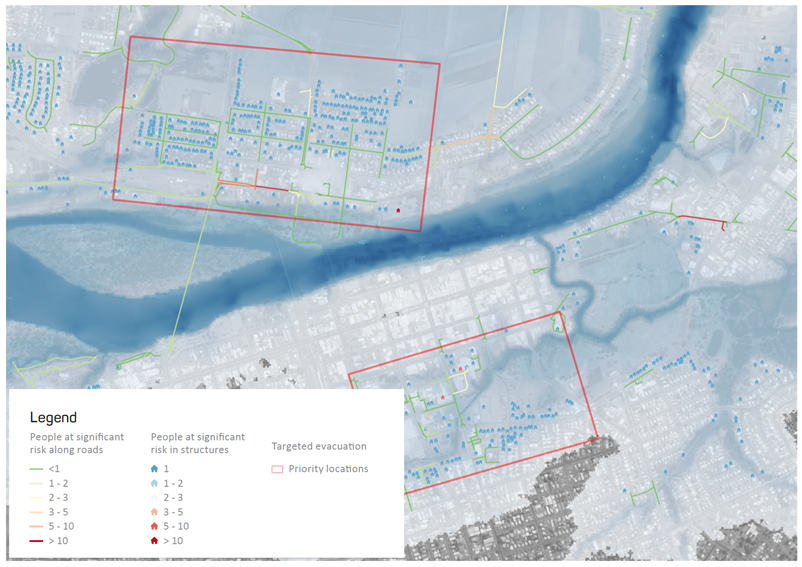
Figure 1: Spatial distribution of people at significant risk with evacuation areas highlighted in red (right).
Conclusions
This paper introduced HEC-LifeSim and outlined 2 case studies to demonstrate its application to estimate the benefits of improving various elements of the TFWS. It also showed the use of HEC-LifeSim to evaluate emergency evacuation routes and plans. A particular advantage is that the benefits of developing elements of the TFWS, either individually or as a package, can be determined without bias towards either the technical (e.g. data and forecasting) or social (e.g. awareness and behaviours) aspects. As HEC-LifeSim tracks the movement of individuals via the road network and provides a representation of population redistribution, it can provide useful insight into effective evacuation routes and destinations. This is an important part of the response element of the TFWS.