New Zealand’s geographical and geological position in the Pacific puts its communities at risk, so early warning systems are a critical component of New Zealand’s emergency management system.
New Zealand communities are exposed to a broad range of natural hazards including earthquakes, tsunami, storms, flooding, fire, landslides and volcanic activity. New Zealand also faces hazards and risks from other sources; from plant and animal diseases, pandemics, technological disruptions and security threats. Early warning systems that enable individuals and communities threatened by hazards to act quickly to reduce the likelihood of death, injury and damage to property are critical to reducing risk and saving lives.
Over the past decade, the National Emergency Management Agency (NEMA), formerly the Ministry of Civil Defence & Emergency Management (MCDEM), aided by its partner agencies, has been on a journey to boost its ability to provide early warning of significant threats to communities.
Two core pieces of technology, Emergency Mobile Alert and Deep-ocean Assessment and Reporting of Tsunami (DART) buoys, have made a significant difference.
Emergency Mobile Alert
In the early hours of Sunday 18 February 2018, many residents of Bell Block, a small town north-east of New Plymouth, were woken by a loud noise emanating from their mobile phones. The alert warned people to shut doors and stay inside due to a serious and life-threatening ammonia gas leak. This was the first time New Zealand’s new early warning technology had been used for a real event.
When there are serious threats to life, health or property, the Emergency Mobile Alert system is used to send alerts to compatible mobile phones within a defined geographical area. The alerts can only be sent by authorised emergency agencies.
Emergency Mobile Alert uses cell-broadcast technology, which is reliable in an emergency. Cell-broadcast technology uses a dedicated channel on mobile networks and it is not affected by network congestion. Unlike text messages, Emergency Mobile Alert is secure and doesn’t require the phone numbers and other private details of recipients to operate. There is also no need to download an app or subscribe to a service. Alerts are broadcast directly to all capable phones in range of the cell towers in the defined geographical area.
In order to speed up the warning process, the system contains message templates for a range of hazards and scenarios. These have been written in line with best practice guidelines for writing effective short warning messages. Issuing warning messages that can be comprehended by the people receiving them is critical for people to take the necessary actions to stay safe.
Since the system launched on 26 November 2017, Emergency Mobile Alert has been used more than 20 times for a range of events. These have been for local notices to boil water, evacuations due to flooding and fire, alerts for gas and ammonia leaks and, more recently, for nationwide COVID-19 pandemic alerts.
Research following a nationwide test of the system in November 2019 showed that among New Zealanders who have access to a mobile phone, 79 per cent received the test alert and a further 8 per cent who didn’t personally receive the alert were near someone who did. New Zealand’s Emergency Mobile Alert is an effective system for reaching people directly in an emergency.
DART buoys
Over recent years, we have increased our understanding of tsunami risk to New Zealand thanks to international experiences and research undertaken. In particular, seismic modelling completed in August 2018 confirmed that some earthquakes capable of generating a tsunami along the Kermadec subduction zone, up to and including Magnitude 8 to 9, will not be strongly felt in the regions closest to the source. The first waves with heights of over 5 metres and potentially over 15–20 metres in susceptible coastlines may arrive at the nearest coast in less than 60 minutes. This means the well understood public education message of 'Long or Strong, Get Gone' will not protect people for these events. A large tsunami with very little warning time and no natural warning signs creates a specific challenge for keeping people safe.
It is clear that New Zealand faces significant life-threatening tsunami risks and it is critical that we are able to provide early warning to at-risk coastal communities.
Work had been progressing to assess the possibility of a New Zealand-owned DART buoy network. Following the Kermadec modelling, this work was accelerated and, in late 2018, MCDEM, the Ministry of Foreign Affairs and Trade, the Ministry of Business Innovation and Employment, GNS Science and New Zealand Institute of Water and Atmospheric Research (NIWA) commenced work to establish a NZ$48.3 million New Zealand-owned DART buoy network to provide coverage for New Zealand and the south-west Pacific. The establishment of the network has been supported by the Australian Government who contributed A$2.5 million to support coverage for Pacific island nations.
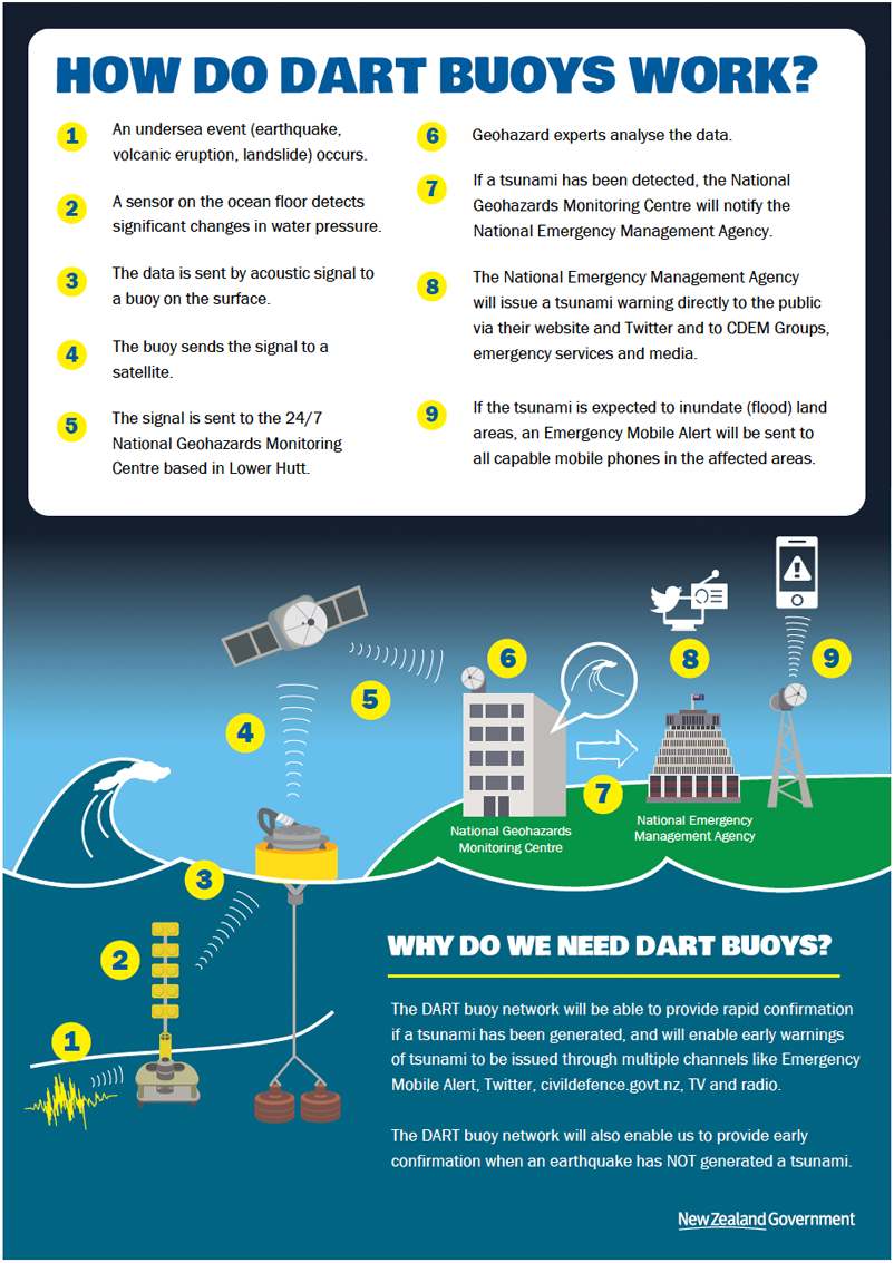
DART buoys are deep-ocean instruments that monitor changes in wave pressure at the sea floor. They are currently the only accurate way, in near real-time, to confirm a tsunami has been generated before it reaches the coast.
DART buoys detect tsunami threats by measuring associated changes in wave pressure via sea-floor sensors. They are capable of measuring sea-level changes of less than a millimetre in the deep ocean. Two-way communication between a DART buoy and a 24/7 monitoring centre allows rapid assessment of threats and provision of advice to NEMA. When a threat is identified, NEMA issues subsequent warning advice to the public. Figure 1 shows how the buoys work by monitoring sea floor wave pressures and sending the information to shore.
Not all disturbances at the sea floor such as underwater earthquakes or volcanoes cause tsunami. The DART buoys also provide rapid confirmation when no tsunami has been generated following large earthquakes and other possible ‘trigger’ events in the ocean, enabling us to quickly get out the message that there is no tsunami threat.

DART buoys on board the NIWA RV Tangaroa on the first deployment voyage into the Pacific Ocean.
Image: National Emergency Management Agency
New Zealand has obtained the latest 4G DART buoys, which can be positioned closer to tsunami-generation sources and are able to detect and precisely measure tsunami better than older-technology DART buoys.
NIWA is deploying the DART buoys using their research vessel Tangaroa and the first deployment voyage took place in December 2019 with the second in August-September 2020. A third and final deployment voyage is scheduled for 2021.
Seven of the DART buoys have been located to provide the best protection from the highest-risk areas close to New Zealand. Locations were based on geological and ocean science information. Another 5 of the DART buoys will be located closer to New Zealand’s Pacific neighbours and near significant southwest Pacific risk areas. Additional DART buoys will be kept on land as back-ups and to make maintenance and servicing more efficient.
We have been able to develop this network now because we have two critical elements in place. The GNS Science National Geohazards Monitoring Centre was established in December 2018 and provides the necessary 24/7 monitoring capability to receive, process and analyse the data from the DART buoys. Our Emergency Mobile Alert system also means NEMA is better placed to issue tsunami alerts to people in New Zealand so they can take appropriate action.
Our Pacific neighbours will also benefit from more accurate tsunami warnings as the network also provides tsunami monitoring and detection information for southwest Pacific countries including Tokelau, Niue, the Cook Islands, Tonga, Samoa, Australia and South and Central America depending on where the tsunami may be generated. The Pacific Tsunami Warning Centre will use data the buoys generate to provide tsunami threat advice to other Pacific countries.