Activities in defendable space areas: reflections on the Wye River-Separation Creek fire
Maria Kornakova, Alan March, University of Melbourne, Melbourne, Victoria.
Peer-reviewed Article
Submitted: 23 October 2016. Accepted: 18 November 2016.
Abstract
Article
Introduction
On Christmas Day 2015, bushfires devastated two Victorian coastal towns: Wye River and Separation Creek. Although the weather conditions in which the fire occurred were estimated at FDI 49, within the Very High (or lower level of Severe) rating, it was considerably less than the FDI100+ Catastrophic category that the regulations address. This raises questions regarding the impacts of the fire including the destruction of 116 houses and other damage that occurred in the two towns (Victorian Government 2016). It has been acknowledged (Leonard et al. 2016) that the main reason for these structural failures related to the quality of housing stock and the specific nature of the location as well as the upkeep of the structures and their surrounds. This fire event demonstrates that simply following regulations relating to bushfire-resistant structures may be insufficient and that more attention should be given to the characteristics of the spaces surrounding dwellings and settlements. To understand the nature of defendable space around dwellings, a description of defendable space is provided.
A variety of studies in this field discuss the relationship between defendable space and structures, focusing on structure integrity (Syphard, Brennan & Keeley 2014). Other studies analyse the role of residents and their influence on the various elements within the space (Nelson et al. 2004). To complement the literature, this paper demonstrates the purposes and potential uses of defendable space immediately before, during and after fire events, emphasising activities during events. The diagrams developed illustrate the use of this space at different stages of fires. They provide a visual aid to demonstrate the importance of planning and designing defendable space, acknowledging that some challenging sites might call for measures that go beyond the standard approaches set out in planning and building regulations. For example, existing settlements might have small distances between structures and it is highly unlikely that owners will voluntarily rebuild or remove their houses prior to an event. In addition, it might be not possible to provide adequate, defendable space due to topographical limitations or lot size. However, it is generally possible to modify vegetation located in the immediate vicinity of structures, or to educate residents about improved building design, maintenance and use of spaces.
Defining defendable space
The terminology of defendable space in Australia differs across states and territories (see Table 1). For example, in NSW it is known as the Asset Protection Zone (APZ) (NSW Rural Fire Service n.d.) and in Western Australia the Building Protection Zone (Department of Fire and Emergency Services 2016). Aside from terminology, these zones differ in size and treatments required. South Australia, for example, specifies a 20-metre treated buffer between the main structure and potential fuel loads (South Australian Country Fire Service 2010). Tasmanian services divide defendable space into two zones: building protection zone (BPZ) and the fuel modified buffer zone (FMBZ) (Bushfire Planning Group 2005). Victoria previously used a similar concept, but referred to them as outer and inner zones (Department of Planning and Community Development 2012). The Department removed outer zone requirements in July 2014 to ease restrictions for planning and building permits (Government of Victoria 2014).
Table 1: Terminology and particularities of defendable space used across Australia.| State | Description |
|---|---|
|
ACT |
The Strategic Bushfire Management Plan 2014-2019 identifies areas at risk through mapping Bushfire Prone Areas, within which Fire Management Zones prioritise fuel management and access activities, and more specifically on urban edge apply Bushfire Abatement Zones. |
|
New South Wales |
An APZ is an area that ‘provides an environment in which a person can undertake property protection after the passage of a bush fire with some level of safety’. |
|
Northern Territory |
Planning controls and regulations refer to the Bushfires Management Act NT1 where land is within a Fire Protection Zone and requires a firebreak. The Act sets a minimum firebreak as four metres around houses, caravans, structures, stationary engines, bulk fuels, haystacks, cordwood or stacked sawn timbers on the land. More specific distances depend on uses and are specified in the NT Planning Scheme, which refers to the Planning Act. |
|
Queensland |
The Queensland Fire and Rescue Service relies on residents and businesses in bushfire-prone areas to have relevant bushfire protection measures in place. These include APZs that provide defendable space for firefighters, adequate access to water for firefighting and emergency management arrangements that are prepared and practiced to minimise the demand and impost on incident management. |
|
South Australia |
Regulations specify defendable space as a 20-metre area around structures where vegetation should be treated to reduce potential fire fuel. Placed within the APZ, it acknowledges to a certain extent the use of space before, during and after the fire front passes is provided. |
|
Tasmania |
Policy divides fuel management areas into two zones (BPZ and FMBZ) with a minimum clearance of 30 metres. The BPZ cannot be less in width than specified for the dwelling. |
|
Victoria |
Defendable space is defined as ‘an area of land around a building where vegetation is modified and managed to reduce the effects of flame contact and radiant heat associated with a bushfire’. |
|
Western Australia |
The BZP is a 20-metre area that must be cleared of flammable objects and vegetation. |
Table 1 shows that despite local differences in terminology and specifications, the concept, purpose and contents of defendable space are similar across Australia. Thus, defendable space is a specified area around primary structures, which aims to reduce bushfire risks through the modification, treatment or removal of fuel sources, provision of adequate roads sufficient for evacuation and firefighting exercises, earthworks (where appropriate) and water sources for active fire defence (Figure 1). This definition suggests a number of elements within the space that must be addressed for its meaningful use. Some of these elements, such as movable structures or temporary constructions, might not be immediately apparent as risk factors, but must be accounted for when defendable space is being planned and managed. For example, Western Australia partially addresses this by requiring all flammable materials be in non-flammable cages a minimum of 20 metres away from the building envelope.
To address these elements it is important to understand how defendable space is created, as well as its purposes and activities that occur within the space. From the perspective of the built environment, a clear understanding of these elements allows for the challenges of managing bushfire risks to be addressed.
Regulations and permits for defendable space are issued under urban planning policies in the first instance. It should be noted that processes to determine a Bushfire Attack Level under building regulations are based on separation from fuel sources that subsequently act as defendable space areas. The primary tests for determining the distances for defendable space are provided by Building Code AS3959, incorporated into planning schemes that provide additional detail relating to the design and regulation of this space. In some cases, owners might seek advice from accredited consultants. Building codes also regulate externally attached structures and outbuildings in some cases (e.g. terraces, decks and sheds).
Figure 1: A diagram showing generic defendable space around a property.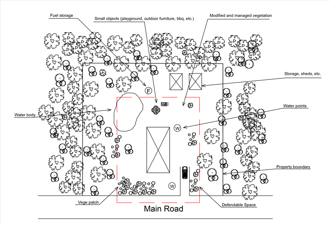
Augmenting the resistance of structures
The use of defendable space is divided into activities. This paper is divided into activities immediately before, during and after fire events. It is acknowledged that activities undertaken outside the bushfire season can significantly impact defendable space, such as gardening and building maintenance regimes.
Separation from the heaviest fuel loads
The main purpose of defendable space is to provide separation (regulated as horizontal distance in metres) between structures and fuel loads that generate heat, embers, potential direct flame contact and tree strike. As can be seen in Figure 2, such fuels include natural and human-made sources. Natural fuels refer to vegetation that can be modified, treated or removed to achieve risk management outcomes depending on the context and other regulatory requirements of the area. Modification of vegetation refers to landscaping and choice of species. In fact, some fire-resistant species can be used as partial shields for structures (CFA 2012). Treatments include tree or vegetation removal, clearing of under-canopy bark and shrubs and removal of understory vegetation to reduce the possibility and intensity of ground fires and reduce the intensities that could sustain crown fires. Human-made fuels refer to small structures on site, movable objects, motorised vehicles, external house-use objects (e.g. doormats and furniture), incidental fuel sources (e.g. gas vessels) and storage areas (e.g. under-house storage). These may be regulated to minimise their negative impacts.
Figure 2: A typical house with human-made and natural fuel sources in Wye River.
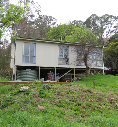
Image: Maria Kornakova and Alan March
As demonstrated in the Wye River and Separation Creek fires, place-specific conditions may pose some challenges to the separation of houses from fuels. For example, a reliance on bottled gas and wood for heating, which are often stored immediately adjacent to or under structures, can potentially be additional fuel sources. This could be addressed by adopting regulations similar to those in Western Australia. It is worth noting that trees can also pose risks from tree strike caused by strong winds and fire (Figure 3). The steep topography of the area requires construction of stilt-type houses, often with understories. These understories are typically open to the environment and are often used for storage, including combustible materials, which can easily become fire transmission points.
Figure 3: A house on Wallace Street, Wye River damaged by tree strike caused by fire.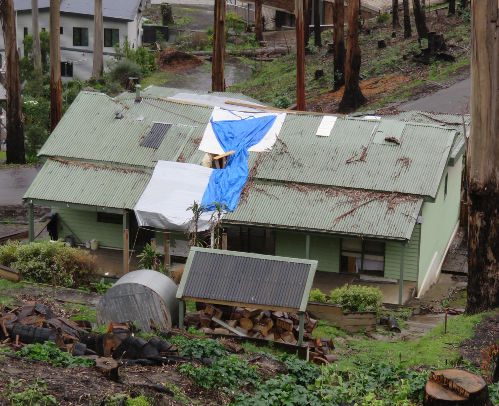
Image: Maria Kornakova and Alan March
Problems associated with achieving sufficient separation from fuels can be addressed by using shared or collective defendable space. This occurs when a number of properties, usually designed in conjunction, share space that separates the structures from fuel sources. This can be achieved when several property areas establish defendable space sufficient to cover other sites, or if boundaries of neighbouring properties are within specified areas for risk treatment (Figure 4). However, problems can occur with shared use such as potential lack of maintenance or future changes of land use and development if not regulated to ensure it exists in perpetuity. This may be complicated by questions of maintenance responsibilities and multiple ownership.
Figure 4: A schema for shared defendable space where properties adjoin each other.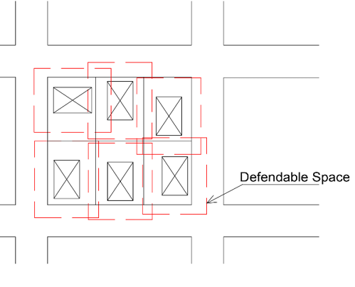
Passive defence
Passive defence occurs when structures are not actively defended or when active defence ceases because firefighters or residents defending the property have to leave or seek shelter, possibly in the structure itself. In addition, what can be referred to as ‘incidental passive defence’ might occur when surrounding properties are defended and the firefront does not reach a property or its effects are significantly reduced. Activities might be the removal of combustibles from neighbouring properties that would propagate a fire (e.g. removal of a boat with petrol tanks on a shared boundary or aerial water drops that slow the passage of a fire on a critical front). Passive defence depends not only on the fuel loads within the space itself, but also on the integrity of structures and the elements that modify risk levels (e.g. gutters filled with water or doormats removed). It should be noted that ember attack may occur well in advance of, or without a firefront, and effective passive defence is key to mitigating such risk.
Active defence
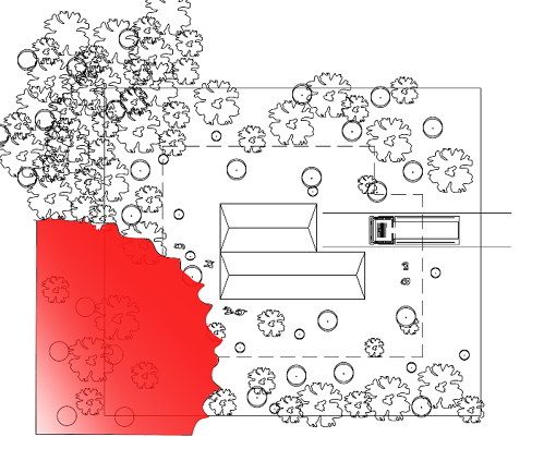
Active defence occurs when firefighters, residents or neighbours defend a structure from ember attack or firefronts using water, earthworks (e.g. using farm or roadwork equipment or removal of key fuels) or simply beat out fires. Challenges here can be associated with initial access to structures (including internal spaces such as roof cavities) and access to all sides of structures. Building Code AS3959 incorporates slope as an input for calculating the separation distance required from key fuels (acknowledging that this assumes a 20° slope maximum) but is expressed as a horizontal distance and it is depicted on plan view drawings that ignore whether or not there is capacity to actively defend in these areas. For example, as shown in Figure 5, steep slopes behind or around a structure limit accessibility. The plan view (Figure 6) suggests that all requirements might not be met if a simplistic approach to assessment were taken. Therefore, there is a need to actively seek alternative solutions and interventions, particularly to deal with complex sites. Other impediments to active defence include fences, locked gates preventing access between or within small structures, such as sheds, or objects left behind by residents.
Figure 5: A schematic section of a defendable space in steep terrain at the active defence stage.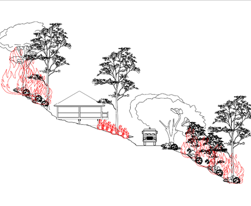
Figure 6: A plan view of defendable space at the active defence stage.
Public roads are often part of defendable space and can play an important role in providing separation between fuels and structures. They also provide important access points for firefighting purposes. A key challenge with including roads as part of defendable space is the potential difficulties associated with their use in active defence in particular settings. For Wye River and Separation Creek, Figure 7, taken in the recovery phase, demonstrates how the terrain prevented road construction suitable for safe use by fire trucks. In this case, the slope of the driveway does not allow access to the structure even though road widths adhere to standards.
Figure 7: A typical road pattern in Wye River that prevents the easy access to property by fire trucks.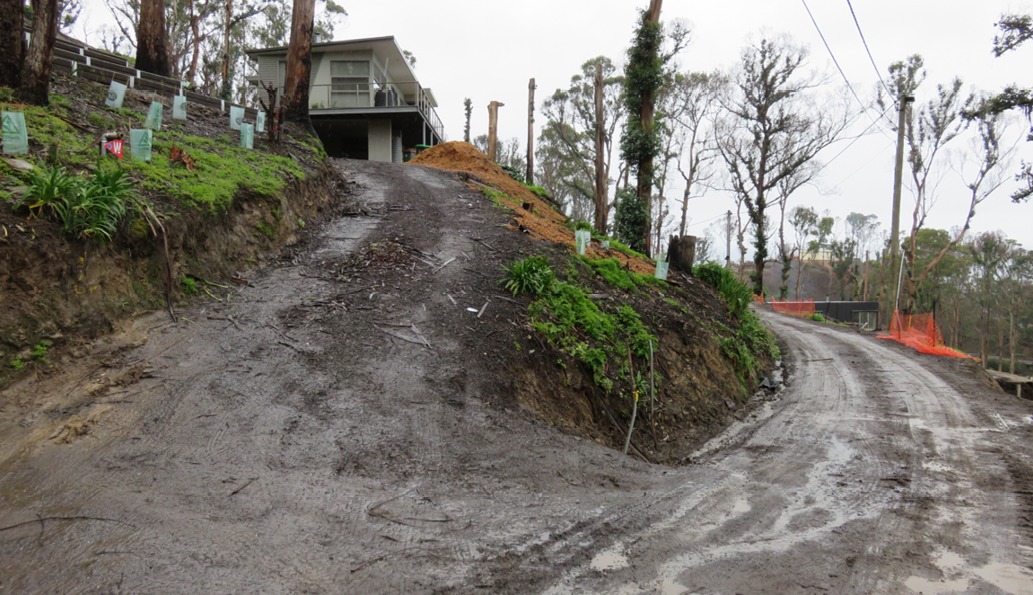
Image: Maria Kornakova and Alan March
Secondary fuels and transmission
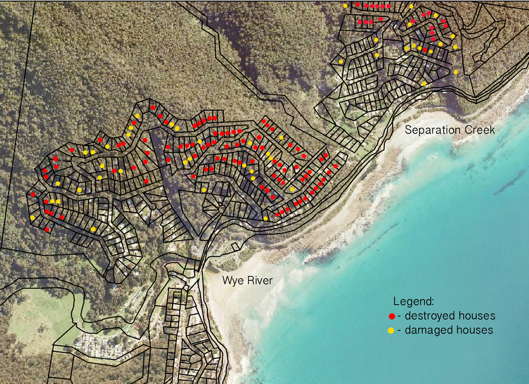
The statutory basis of defendable space in existing settlements tends to be developed on an individual site or lot basis, enforced via building and planning permits. These often ignore surrounding structures and conditions on neighbouring land and the quality and defendability of neighbouring structures are not addressed. Wye River and Separation Creek examples show how defendable space can fail to fulfil requirements in respect of nearby structures on separate lots. Figure 8 shows how the majority of houses on some streets in Wye River were destroyed, probably by house-to-house ignition (Leonard et al. 2016). While existing house stock might not immediately and easily address defendable space requirements under existing planning regulations, alternative solutions include locating houses with consideration of the local environment as part of ongoing planning processes. Defendable space should not be analysed and seen exclusively as part of an individual structure alone, but rather it should be placed within larger rural or urban patterns and be part of the long-term change management process.
Figure 8: Map of destroyed and damaged houses in Wye River and Separation Creek (based on Leonard et al. 2016).
When structures fail
Activities occurring within defendable space areas may be commenced or recommenced after a firefront passes. It might be used as a refuge by its residents or active defenders after a structure fails and is no longer habitable or when retreat from a firefront is required. Occupants may use the space to fight residual fires, preventing the structure from burning after the main fire front has passed. Obviously, this activity is possible only when there are no significant fires within the defendable space itself. A second condition for safer refuge is a lack of hazardous structures or trees in the proximity.
Conclusions
The potential to facilitate important risk reduction activities in defendable space areas is dependent on appropriate design and planning exercises. There is a need to improve understandings of the range of activities undertaken within defendable space so that building planning and construction achieves risk management goals. The limitations of defendable spaces and design solutions should be clearly understood by firefighters and building design professionals so they may seek alternative ways to address risks. Reconsideration of some aspects of existing policies and regulation is also required.
The examples of Wye River and Separation Creek are indicative of regulation having a tendency to view space as two dimensional and on a site-by-site basis. Rather, regulation needs to consider the particular characteristics and wider environmental settings of sites, both natural and human-made. Urban planning and urban design have tools and mechanisms to address the challenges that could be integrated with bushfire risk measures. For example, coordinating a dwelling’s building envelope on lots to ensure maximum distances between structures can be used as a successful technique. However, alternatives must be sought in collaboration with other disciplines.
This paper considered the purpose of defendable space. There is a need to further investigate use of this space by residents and officials times when there is no need for active fire defence. This will address such challenges as storage of combustible or hazardous materials storage and placement of incidental fuel sources.
References
ACT Government 2014, The Act Strategic Bushfire Management Plan 2014 - 2019. Canberra, ACT: Publishing Services for the Emergency Services Agency.
Bushfire Planning Group 2005, Guidelines for development in bushfire prone areas of Tasmania. Living with fire in Tasmania 2005. Hobart, Tasmania Tasmania Fire Service.
Country Fire Authority (CFA) 2012, Landscaping for bushfire. Garden design and plant selection, Melbourne.
Department of Fire and Emergency Services 2016, Building Protection Zones. At: www.dfes.wa.gov.au/safetyinformation/fire/bushfire/pages/bushfireprotectionzones.aspx.
Department of Planning and Community Development 2012, Defendable space in the Bushfire Management Overlay. At: www.dtpli.vic.gov.au/__data/assets/pdf_file/0004/258412/AN44-Defendable-space-in-the-BMO-including-technical-report.pdf.
Department of Transport Planning and Local Infrastructure 2014, Planning Practice Note 65. Preparing and Assessing a Planning Application under the Bushfire Provisions in Planning Schemes. Victorian Government. At: www.dtpli.vic.gov.au/__data/assets/pdf_file/0010/258571/PPN65-Preparing-and-Assessing-a-Planning-Application-Under-the-Bushfire-Provisions_-4-September-2014.pdf.
Government of Victoria 2014, Planning and Environment Act 1987. Amendment VC 109 Explanatory report. Melbourne: State Government Printer.
Leonard J, Opie K, Blanhci R, Newnham G & Holland M 2016, Wye River / Separation Creek Post-bushfire building survey findings, CSIRO Client Report EP16924.
Nelson KC, Monroe MC, Johnson JF & Bowers A 2004, Living with fire: homeowner assessment of landscape values and defensible space in Minnesota and Florida, USA. International Journal of Wildland Fire, vol. 13, no. 4, pp. 413-425. doi:http://dx.doi.org/10.1071/WF03067
Northern Territory of Australia 2014, Bushfires Management Act. At: http://notes.nt.gov.au/dcm/legislat/legislat.nsf/2afcb7bfe1e1348e6925705a001697fb/bff0065c7bebf7ce69257d900021e24f/$FILE/ATTNDUKM.pdf/Repb004.pdf.
Northern Territory of Australia 2016, Northern Territory of Australia Planning Act. At: www.austlii.edu.au/au/legis/nt/consol_act/pa100/.
NSW Rural Fire Service (n.d.), Dictionary/Terminology: Defendable Space. At: www.rfs.nsw.gov.au/plan-and-prepare/building-in-a-bush-fire-area/planning-for-bush-fire-protection/dictionary-terminology.
Queensland Fire and Rescue Service 2016, Building Fire Safety. At: www.qfes.qld.gov.au/buildingsafety/.
South Australian Country Fire Service 2010, Development principles policy, At: www.naturalresources.sa.gov.au/samurraydarlingbasin/publications/bushfire-prevention-bushfire-management-zones.
Syphard AD, Brennan TJ & Keeley JE 2014, The role of defensible space for residential structure protection during wildfires. International Journal of Wildland Fire, vol. 23, no. 8, pp. 1165-1175. doi:http://dx.doi.org/10.1071/WF13158
Victorian Government 2016, Review of the initial response to the 2015 Wye River – Jamieson Track fire.
At: www.igem.vic.gov.au/home/reports+and+publications/reports/report+review+of+the+initial+response+to+the+2015+wye+river+jamieson+track+fire.
About the authors
Dr Maria Kornakova is a Research Fellow in Urban Planning and Disaster Risk Reduction in the Faculty of Architecture, Building and Planning at the University of Melbourne. Her research investigates the complex subject of risk and hazard treatments in the built environment, including aspects of social, ecological, economic systems, with particular focus on governance issues.
Dr Alan March is Associate Professor in Urban Planning in the Faculty of Architecture, Building and Planning at the University of Melbourne. He is Director of the Bachelor of Design. His research includes examination of the practical governance mechanisms of planning and urban design and the role of urban planning in reducing disaster risks.