Now is the time to integrate long-range uncrewed systems into our national emergency response capabilities.
Imagine this: multiple bushfires are burning across the state, and aviation resources are strained as multiple states are hit at once. Firefighters are desperate for up-to-date fire mapping information so a local long-range drone is deployed to gather information for several fires in the area. This reduces the load on conventional crewed aircraft services. The drone crew deploys in the evening using a medium-sized drone with a flight endurance of over 6 hours within 100km of the ground control station. The drone completes its mapping activities and the crew delivers the fire mapping data to the local Incident Commander who incorporates it into resource planning for the new day.
Or this: a bushfire in a state forest is started by a strike of lightning overnight. The fire grows slowly throughout the night, limited by wet ground from rain during the storm but begins to plume smoke into the new day. However, a drone-in-a-box unit is on a pre-programmed patrol of the forest and discovers the plume. This drone is one of many in an integrated network of remotely piloted drones carrying out remote and repeatable monitoring roles. Similar drones undertake flights monitoring for sharks along the coast. The drone flies as close as it can to the fire within its 3km range and, using 2 different viewpoints, takes photos that help to determine the direction and location of the plume. These photos are supplied to the State Emergency Operations Centre that dispatches a local crew to review the ignition.
These examples show how having access to exact and current information in a changing situation can greatly assist decision-making and reduce time and the waste of valuable resources. Over the past decade, drone technology has evolved rapidly and has transformed many industries through accessible and localised aerial vision and data collection. This information improves situational awareness and logistical support. In critical scenarios, from search and rescue to disaster response and all manner of public safety and community good settings, drones and their pilots provide immediate data and additional perspectives by collecting huge amounts of data that can be used to save lives. However, while drones within visual line of sight1 are increasingly common there has been a delayed adoption of larger, long-range unmanned aerial vehicles (UAVs) across the emergency management sector. By taking a whole-of-government approach to UAV deployment, emergency response capabilities could reach new heights in effectiveness and coordination.
Drone capability
Drones improve safety to emergency responders in high-risk situations by reducing or sometimes removing the need for human involvement in hazardous situations. In scenarios such as aerial bushfire monitoring, structural fire assessment and flood response, drones can safely enter environments that would pose significant danger to personnel.
This approach can reduce, where possible, the exposure of responders to risks inherent to crewed aircraft firefighting as well other risks like heat, smoke, hazardous chemicals, unstable structures and flood waters. By using drones for real-time intelligence gathering as well as data collection, emergency services agencies can make better decisions without endangering lives. This is a significant contribution to the safety and effectiveness of personnel.
Drones can lead to significant cost savings for emergency services organisations. The operational costs associated with crewed aircraft (e.g. fuel, maintenance and skilled personnel) can be substantially higher than the costs of drone operations. Drones can layer with existing crewed assets and data can be collected across an entire day and overnight using thermal sensors. This provides the most current and fresh data for crews in the morning.
Drones play a vital role in prevention and mitigation efforts. By pre-positioning drone assets, while other assets perform response functions, emergency services agencies can conduct regular monitoring and surveillance of areas at high risk to bushfires or flooding. This proactive approach aids in timely evacuations and resource allocation and can build community resilience as it helps communities and authorities implement preventive measures before events escalate. Ultimately, the use of drones contributes to reducing the overall effects for communities that can save lives and optimise use of resources in the process.
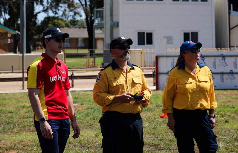
Drone operators maintain visual line of sight of an airborne drone.
Image: Australian UAV Service
Drone technologies
Visual line of sight drones
Visual line of sight drones (VLOS) are flown within the visual range of the operator. These have become a familiar and widely used tool within Australia’s emergency services sector. Since VLOS flights keep the drone in view at all times, the pilot can respond directly to on-the-ground changes, while local airspace is actively managed in real time. VHF airband radio and flight-tracking data are the primary methods for avoiding collisions, especially when there is conventional aircraft in the vicinity.
Applications
Due to their ease of deployment, straightforward training requirements and all-weather and high-wind resistance, VLOS drones are typically used in scenarios where immediate local support is needed. Examples include monitoring a local incident scene (flood, fire, damaged house, beachgoer in trouble, shark sighting or infrastructure damage), rapid response to an unfolding incident or helping direct rescue operations within a short radius. This layer has been integrated within many emergency response agencies and responders on the front lines have been trained to use them as tools during operations.
Drone in a Box
A recent evolution in drone technology is Drone in a Box (DIAB) that has provides an additional layer of emergency response capability and proactive patrolling. Drone flights are enabled by hubs that are ‘docks’ that recharge and connect to sub-7kg drones to allow remote piloting from a separate location (e.g. Surf Life Saving New South Wales has operated a DIAB system in Evans Head on the northern coast of New South Wales piloted from Sydney, 700km away). The DIAB system includes a base unit with tools like ADS-B receivers2, VHF radio and parachutes to ensure safe operations over people and within controlled airspace.
Benefits for emergency response
DIAB systems provide unique advantages for emergency response by enabling proactive (ongoing monitoring) and reactive (sudden response) missions. For example, these drones can autonomously conduct repeated missions such as crowd monitoring, shark spotting, flood-level surveillance or fire hotspot checks. If an emergency arises, they can quickly pivot to searching for a missing person, recording storm damage, mapping of a fire front or inspecting critical infrastructure. As such, DIAB systems provide additional capability for emergency services organisations and do not replace the drone pilot on-scene who is quickly adaptable to changing situations.
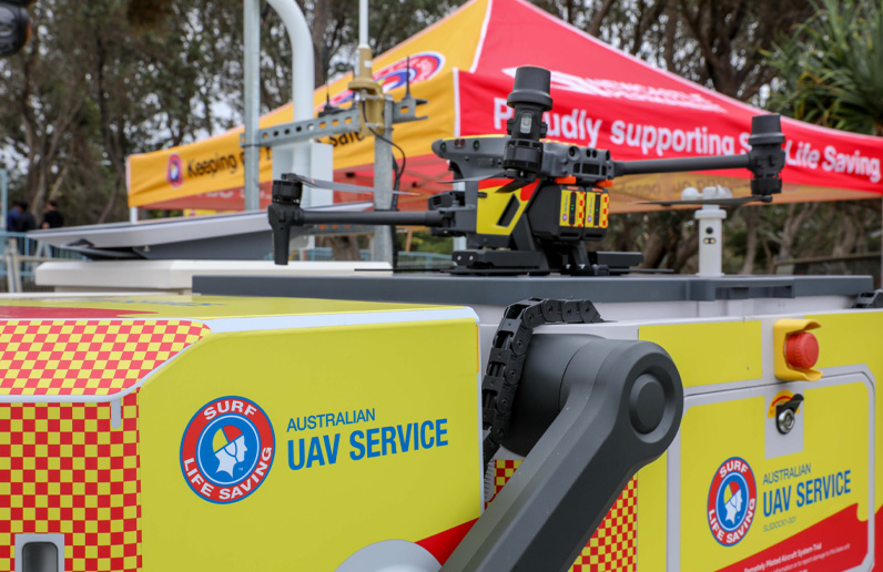
Beyond visual line of sight drone-in-a-box is a recharge and connect hub for remote operations.
Image: Australian UAV Service
Long-range drones
Long-range drones, typically fixed-wing craft, provide extended flight durations and range. This allows them to cover much greater distances at higher speeds. This is particularly valuable in remote or challenging terrain and enables flight times that can exceed 2 hours. This reduces the cost of collecting data as the same pilot, spotter and data specialist crew is able to capture a larger amount of data per deployment.
Expanded mission profiles
Long-range drones bring essential benefits to regional and remote emergency responses. These drones can carry out large-area surveillance, which makes them effective for use in bushfire monitoring, large-scale flood response and regional damage assessments. These drones provide real-time information for situational awareness and specialist intelligence gathering by virtue of their flight time and range. By incorporating long-range drones, emergency services organisations can increase agility prior to and during emergencies with the capacity to collect data, observe and respond to incidents across vast areas.
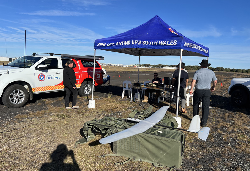
Beyond visual line of sight long-range drones cover greater distances at higher speeds.
Image: Australian UAV Service
The case for a whole-of-government approach to drone deployment
The current drone deployment approach within the emergency services sector is somewhat fragmented. Most agencies manage their own UAV programs. This can be the right approach for visual line of sight drone programs where internal UAV teams allow small drones to be placed in the hands of front-line personnel to collect data at a local level. However, for larger UAV platforms that conduct long flights in beyond visual line of sight situations, adopting a unified, whole-of-government approach would bring a variety of benefits:
- Cost efficiency: Centralised procurement, training and maintenance can reduce redundancies and optimise resource allocation. With a standardised fleet, agnostic of platform make and model, emergency services organisations can scale and adapt operations using shared resources.
- Shared expertise and best practices: Emergency services agency collaboration would allow for the pooling and sharing of knowledge that would improve training standards and operational protocols.
- Interoperability and data-sharing: Establishing common platforms, data-sharing protocols and communication systems between agencies would enable a better flow of information during events and improve response coordination. This has a direct effect on safety and means agencies can better understand where their various long-range drones are.
- Enhanced coordination: A unified approach to drone deployment enables coordinated responses to large-scale emergencies that involve multiple agencies. This can create an integrated and efficient crisis response system.
- Shared approach to regulatory processes: While it is possible to get approvals to undertake most drone operations (with flight DIAB operations over populations being the only one yet to be granted approval), these approvals are geographically bound. In a unified fashion, emergency services organisations could partner to seek approvals for large swathes of regional areas as a starting point. This would enable the first sites for as-needed DIAB long-range operations and could progress to other complex airspaces and ground risk sites.
Conclusion
The adoption of a unified drone approach could significantly transform emergency response across Australia. By centralising procurement, training and deployment, and by standardising protocols, agencies can coordinate and respond to crises with greater agility and efficiency. A whole-of-government approach would allow drones to support crisis response, beginning with remote bushfire zones and, in the future, expanding to the urban fringe and urban areas. This provides an adaptable, lower-risk and cost-effective approach to managing emergencies.
It is important to note that there has been significant advancement of drone adoption for emergency response. This is particularly so by the Australian Association for Uncrewed Systems that actively advocates and assists in integrating the use of UAVs across a range of uncrewed use cases. The Aviation White Paper—Towards 20503 lays out the key positive approaches including electronic conspicuity and airspace management that, as these are delivered, will enable drone use during emergencies with increased safety and reduced regulatory burden.
It is essential for government policymakers and stakeholders to advance long-range UAV capabilities within the emergency services sector. By having a unified, standardised emergency service drone strategy and implementation, Australia can harness innovative technology to protect responders and communities.