The US-China balloon incident of February 2023 triggered the thought that stratospheric balloon technology (SBT) would be a useful addition to satellite observations for early warnings, disaster management and recovery systems in Australasia. Special properties of SBT are that balloons can hover over a disaster site for long periods of time; can operate closer to the ground, but out of the way of air traffic; can capture higher-resolution images and photographs; can use instruments similar to satellites and can gather images and data for modelling in real time. Currently, decision-makers rely on combinations of information sources such as satellites, aircraft ‘line scans’, command aircraft, drones, mapping systems and aerial photography to gather information and combine it. This is a lengthy process. SBT has made its way into disaster monitoring at official trials during active wildfires in the USA and into mobile communications during Hurricane Maria in 2017. No evidence was found that SBT has been used in early warnings or emergency and disaster management in Australasia, notwithstanding its potential advantages over satellite technologies, especially in the southern hemisphere where satellite coverage is relatively scarce. This study explored SBT by reviewing and analysing publicly available reports and secondary data. This paper concludes that it is an opportune time to re-evaluate the performance, properties and contributions that SBT can make to monitoring and early warnings.
Background: the US-China ‘spy’ balloon incident in the Australian context
The US-China balloon incident of February 20231 was a timely reminder that Australian researchers were once significant partners in the ‘state of the art’ international domain of stratospheric balloon research. Since 1974, over 130 launches have been made from the balloon launching station at Alice Spring Ballooning Facility in the Northern Territory in collaboration with global researchers from France, Japan and NASA as well as for Australia’s research in space and astrophysics. The most recent partner to conduct experiments was Japan in 2023. Further prospects are likely with the recently established space agency in the Northern Territory (Department of Trade, Business and Asian Relations 2024) that will launch stratospheric and near-space apparatus.
The US Government has not provided any evidence to the public of novel technology on the Chinese stratospheric balloon that strayed into US airspace and what information China might have gathered by way of visual and technical observations. This may have included spying or ‘eavesdropping’ at ground level and below during its flight over hi-tech military facilities. The instruments onboard were thought to include cameras, multiple-sensors, radio, sonics and vibration instruments, which can help to determine and measure voice, radio and mechanical and electrical activities at a higher resolution than equivalent satellite instruments. Communications were made through international commercial networks.
The dominant applications of SBT are astrophysics, atmospheric testing and research, military intelligence, ground environment conditions, communications and testing space instruments for use in satellites. There is, however, a growing interest in supporting specialist tasks, including trials for earlier detection and situational awareness during bushfires (Gabbert 2021, 2022; Coxworth 2021). There are also potential benefits from SBT if applied for other disaster management tasks and community resilience support, including early monitoring for fires and floods, and communications during and after a events such as earthquakes and volcanoes.
In June 2023, the US-China balloon incident was publicly declared ‘over’ when the US Government announced that spying information had not been collected by the Chinese balloon while it hovered over the USA.
Aim
The US-China balloon incident triggered the research interests when it was realised that there is a remarkable similarity between the instrument types purported to be on the Chinese balloon and those used in satellites for disasters, environmental monitoring and situational awareness. This prompted broad questions of:
Is SBT better, an alternative to, or complementary to, existing satellite information and communication technology for early warnings and pre-, post- and during major disaster events, and remote sensing in general or in niches, such as major disasters?
A simple calculation of relative distances from the ground level (satellite verses balloon) showed that using the same instruments onboard each, the SBT could produce 7 to 10 times the magnification of images from the satellite, just based on their relative distance above the ground. Such higher magnification would also mean that SBT can undertake faster information collection than say, line-scanning ‘fit for purpose aircraft’ now in use, potentially speeding up the fire behaviour and prediction processes. Furthermore, as balloons can hover over or near to a site, they can produce real-time results and quickly retrace the territory magnified, giving it competitive advantages over advanced ‘stationary satellites’, without the high development and operating costs.
The aim of this research was to explore public information to establish if SBT is an alternative remote sensing and information gathering technology suited to provide early warnings by providing more detail, faster information and communications to more decision-makers. The early investigation undertaken represents the initial step in addressing the question, ‘are stratospheric balloons the next technology for early warnings and monitoring of disasters in Australasia’. Further qualitative and quantitative investigations in technology research, financial analyses and disaster management practice (i.e. a business case) are needed for a definitive conclusion.
Methodology
Context
In this context, ‘disasters’ are catastrophic events that significantly disrupt the normal functioning of one or many local communities that cause human, material, economic or environmental losses on a large scale. These events may be natural, such as mega-fires, earthquakes or widespread floods. They can be human induced, such as accidents, arson or industrial negligence. Effective disaster management requires anticipation of risk and resourcing for community resilience to provide a coordinated response to reduce the effects and aid in recovery.
Disasters occur in nature or as the deliberate or accidental consequences of human activity. Unless responded to urgently and with appropriate resourcing, they will disrupt natural and built environments by causing illness and deaths; damaging and destroying homes, food and water supplies; diminishing marine and agriculture activities and producing business and infrastructure failures in areas of transport, health and communication systems. They erode community and economic resilience and leave people and animals displaced and disoriented.
Notwithstanding the advanced geospatial information systems used in forecasting and responding to a disaster and its aftermath, there are few comprehensive records of disasters as they unfold to enable scientists, engineers and practitioners to re-enact the event, model it or investigate alternative approaches to manage them. What is missing in existing developments is an information system that can record, download and share 3D information and images in real time. Such a system, when sufficiently developed, could be used to improve early warnings and situational awareness in emergency and disaster management and defence applications.
Digital cameras and specialised sensors mounted on satellites or SBTs can capture highly detailed images of Earth through cloud, smoke, rain and tree cover. The advanced devices provide higher clarity comparable to that of a close-proximity CCTV camera and have the capability to focus on specific areas using adjustable lenses. Stereoscope pairs allow for 2 views concurrently, for example, a single bushfire or a wide view containing multiple fires over a larger landscape. SBT has the advantage for detailed monitoring and analysis in real time.
Research questions
- Can we design an effective information system that provides a timely, ‘God’s-eye view’ of disasters and their surrounds, day and night, through smoke, cloud and rain - by combining and using SBT with appropriate technical payloads?
- What are the benefits, constraints and limitations of this information system?
Research strategy
To establish an overview of current technologies in the domain of avionics, which includes high-altitude balloons, aerial drones and satellites, an initial review of their current application was conducted in early 2023. This highlighted that SBT is an active area of research and development in many countries focusing on application to domains that included everything from national security to disasters, to future plans for ‘space tourism’.
As this research progressed, we identified that studies of the application of SBT shared the common operational objectives of being able to achieve richer observations of either space or the Earth and that much of this technology for improved Earth observations exists or is currently under development.
Methods
A search, desktop review and analysis of grey literature, reports and publicly available secondary data and images from social media and the internet was made from 15 February 2023 to 31 August 2024. This review and analysis focused on applied and theoretical use of stratospheric balloons and looked at data and case study accounts most relevant to ‘disaster management’ and that directly referred to NASA, suppliers to NASA, government agencies including defence and various research institutions globally.
This review was thematically analysed using the iterative thematic enquiry approach outlined by Morgan and Nica (2020) focusing on:
- assessing beliefs about SBT
- building new beliefs about SBT that emerge from data analysis
- listing SBT emergent themes
- evaluating SBT activities and benefits in relation to disaster management and the support of community resilience.
Data collection and analyses were inductive in nature and conducted over 3 stages. In stage 1 of data collection and analysis, initial beliefs, in relation to research questions, were reviewed as we were unsure as to the state of technology development and its appropriateness to the application of disaster management (see Figure 1). As data gathering and analysis matured (i.e. gained in momentum and volume, stage 2) we also conducted iterative and connected cycles of belief and thematic development where we reached belief and theme stabilisation.
At the conclusion of the data collection, analysis and deepening of existing knowledge of SBT (stage 3) our settled beliefs supported the conclusion that:
- it is possible to design an effective information system that provides a timely, ‘God’s-eye view’ of disasters and their surrounds, day and night, through smoke, cloud and rain - by combining and using SBT with appropriate technical payloads
- there are benefits constraints and limitations of this information system.
Final themes that support the settled beliefs include:
- how SBT works (including structure, payload and potential operations)
- SBT maximum time aloft (including potential operational lifespan)
- related use of SBT (including various case accounts).
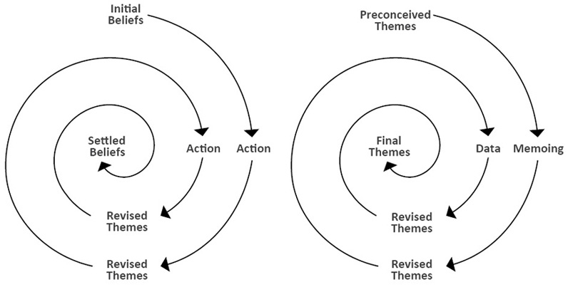
Figure 1: Revising initial beliefs and preconceived themes.
Source: Morgan and Nica 2020:3.
Limitations
This study was not a comprehensive academic literature review. The study did not attempt to quantify the costs, impacts and benefits of SBT use for emergency and disaster management.
While studies are ongoing, it was found that there was sufficient public information available to build an impression of the operational capabilities of the Chinese-US balloon incident account to compare it with case accounts of other SBT that are available. This paper therefore outlines the results of a review and analysis of many publicly available reports and secondary data relating to SBT for much of timeframe of 2023 and 2024.
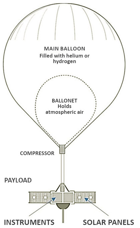
Figure 2: General impression of a ‘zero pressure ultra-long duration balloon’ thought to be like the Chinese ‘spy’ balloon shot down off the coast of the USA in February 2023. Balloon height approximately 65 metres.
How modern stratospheric balloons work
Figures 2 and 3 were compiled from various website sources to illustrate the main components of the Chinese SBT. They represent the more general design elements of a ‘zero pressure ultra-long duration balloon’ similar to those in use around the world.
Navigation
In the upper stratosphere there are winds crossing in many directions in different layers, concurrently. Hence by raising and lowering the balloon with a compressor (heavy air ‘out’ or ‘into’ the ballonet) the balloon can be raised or lowered. At the desired level, the wind will carry the balloon towards the required navigation point. Using the same method, the balloon can hover over the navigation point for days when necessary.
The purpose of the balloon is to support the ‘payload’ within stratospheric wind streams that are relatively calm and navigable as well as out of the pathways of satellites and commercial and military aircraft. Balloon movement is managed from the ground. The operator raises or lowers the balloon in search of a cross wind that will move it in the direction sought. Once the balloon is in the required position, it’s onboard equipment can take high-resolution digital photography of terrain including objects on the Earth’s surface or use digital telescopes to capture images deep into space. The images can be recorded in real time and sent to ground stations for inclusion in decision-making systems.
The movement of balloons in the stratosphere is controlled from the ground. Operators adjust the altitude of the balloon to locate a consistent crosswind that will guide it in the desired direction. Launching a large balloon into the stratosphere and commencing data transmission from an optimal altitude can be achieved within a few hours. Once positioned appropriately, the balloon's onboard equipment captures high-resolution digital photographs of terrain, including objects on the Earth's surface through smoke, cloud, storms and darkness. The balloon can be directed by the ground operator to another location or safely brought down.
There is more to be learnt and applied to recycling large stratospheric balloons and payloads and by 'docking' the SBT for reuse. This approach involves guiding the balloon back to a designated recovery area where it can be safely deflated, inspected and prepared for future missions. By docking the balloon, operators can minimise atmospheric tears, assembly damage and other factors that reduce the lifespan of these balloons. This method enhances the longevity and cost-effectiveness of the balloons and ensures that the valuable scientific payloads they carry can be reused to reduce waste and improve sustainability. US manufacturer, Urban Sky, is experimenting with micro balloons that can be launched from a small truck and recovered by the same vehicle.
The combination of instrumentation attached to a balloon can be varied and continues to evolve in current applications to achieve improved results. Tools such as optical cameras, infrared sensors, radar, communications equipment and visualisers are advancing rapidly for both satellites and SBT. Recent developments in hyperspectral sensors make 3D real-time visualisation readily achievable for decision-making and modelling in smoky and cloudy conditions.
While the tools used on satellites and SBT are similar in nature, balloons have some advantages in the application to emergency and disaster management due to their operational characteristics (i.e. a balloon can be launched at anytime, anywhere if weather permits and where it is safe to do so). Balloons can be used to observe high-risk areas of fires or floods ahead of incidents or when prescribed burns or back-burns are in operation. A balloon can be used to watch for breakaway fires, monitor smoke levels and wind directions over large areas. There are equivalent requirements in the early stages of flooding when waterways are rising, peaking or receding and ground assets are at risk. Many tools exist to penetrate cloud, smoke, pollution and haze.
Balloons can be manoeuvred to monitor for early warnings of fires and are arguably more effective than satellites, though the 2 working together could provide a better solution for early warnings of new fires. As the balloon can hover, while the satellite must travel around the Earth to reach the next data collection point, the task of early detection works in favour of balloon use with equivalent instrumentation. Balloons can also hover over a ‘hotspot’ for a detailed investigation.
Balloons also facilitate greater magnification of images, less complex distortion requiring ortho-rectification, more suitability of data and images for immediate use and better articulation in 3D real-time for data analysis, modelling and decision-making. This is important when further understanding of fire behaviours is required during active fires.
It is normal to have a separate parachute for the balloon payload to avoid breakages of components and ease of recovery when a balloon reaches its end of task. A balloon operator can release the payload, allowing it to descend back to Earth, and, when separated from the payload, the balloon expels the light-gas it is still holding, causing the balloon to collapse and slowly disintegrate.
Information gathered by a balloon may be transmitted from the payload to a ground station during operation in the stratosphere or stored onboard and recovered when the payload is collected. Large balloons on long-term missions such as the Chinese balloon would be able to send information continuously to a base station thousands of kilometres away. Such 2-way directional information (i.e. timely send and receive) requires a radio antenna. An antenna was preliminarily identified on the Chinese balloon as being unusually large, indicating it may also have had sonic detection and radio measuring capabilities.
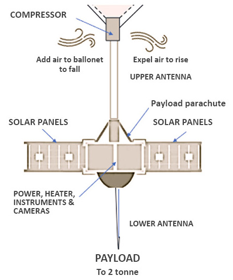
Figure 3: Further details of the ‘zero pressure ultra-long duration balloon’ shown in Figure 2. The zero pressure is achieved by the ballonet and compressor system.
How long can stratospheric balloons stay aloft?
The front-end processes to launch a stratospheric balloon are relatively straight forward and inexpensive compared to a satellite launch. Once a balloon is in the stratosphere and stabilised it can be managed by a ground crew, however, any tear in the balloon skin can be sufficient to break the balloon open, releasing the lighter-than-air gas inside, and forcing a descent. After release, the payload can be tracked by its radio signal to its landing point. Once recovered the instruments are recyclable.
The lifespan of a balloon cannot always be determined in advance and may vary from a few days to 100+ days, depending on many factors including the weather at the operating altitude. Aerostar bushfire (Gabbert 2022), trials were satisfactorily run over 11 to 160 days. In each case, the trial was ceased by the operators and not because of balloon failure.
There is more to know about reusing balloons and payloads by ‘docking’ the entire SBT, which is apparent that the Chinese military does. The most likely cause of failure of a balloon are leaks arising from atmospheric tears or assembly damage. To date, lifespan failures have not been a deterrent to the growing demand for scientific experiments with SBT.
Recent reports on use of stratospheric balloon technology
CSIRO water quality measurements from space: instrument tests
In 2022, Australian CSIRO Space Optics Division Australia used a stratospheric balloon to test the performance of components of the ‘CyanoSat’, a shoebox-sized satellite designed and developed in Australia. CyanoSat, launched in 2024, continuously monitors the health of Australian waterways.
CSIRO used a stratospheric balloon at 20,000 metres to test monitoring systems and a hyperspectral imager in ‘space-like’ conditions where the temperature is around -50C. The results were satisfactory, and the test components were safely returned to Earth.
The hyperspectral imager uses a spectrometer to measure contiguous spectral bands reflecting from the Earth’s surface capturing the information in 3-D data cubes. All objects and materials have a distinct spectral signature which enable their identification within these data cubes, e.g. an algae in a land-water context. This allows their presence in the specific locations on Earth to be detected from the satellite with great accuracy.
CSIRO Space Optics Lab (n.d)
The CyanoSat trials can potentially open the way for other local satellite equipment performance studies and for real-time 3D predictive mapping of flood plains and coastal waters. There areas have an increasing need for strategic decision-making that supports community resilience, especially flood management tasks.
Australia Department of Defence trials
A series of trials of high-altitude balloon launches began in June 2020 with the first balloon launching from West Wyalong in country New South Wales. The aim was to incorporate high-altitude balloons into Australia’s defence capability to deploy advanced sensors into the atmosphere rapidly and cost-effectively to provide comprehensive data in the air, on the ground or at sea.
The Australian Air Force partnered with US company, ThunderStruck Space, and local avionics developer, Flight Design Pty Ltd. This collaboration boosted local capabilities to allows Australian industry to conduct quick and relatively low-cost pre-launch testing of space payloads.
NASA’s Scientific Balloon Program
Following an April 2023 flight test from Wanaka in New Zealand, NASA announced that its Scientific Balloon Program was back on track (SpaceNews 2023). During the test it carried the Princeton University SuperBIT telescope to support deep space science experiments as the balloon circumnavigated the Antarctic 10 times over 11 days. It was also recording detailed scientific information on Antarctic waters, physical terrain and atmosphere. The Antarctica flight balloon was the size of a football stadium when fully inflated at its operational float altitude of33.5 km and was capable of viewing formations on the ground in significant detail.
A second balloon from the New Zealand port departed in May 2023 to test NASA’s super-pressure balloon technology, in contrast to the zero pressure ultra-long duration balloon. The balloon was designed to maintain a positive internal pressure and shape irrespective of its environment. This keeps the balloon at a stable float altitude without the need to release air ballast. It also has internal ribbing to hold the shape of the balloon during operation. Within just a day and half after the launch, it was necessary to bring the balloon down in the Pacific Ocean along with its cargo. Clearly, balloon flights are still experimental, particularly under heavy loads.
While it would be advantageous to receive certification on balloons put into service during emergency events, this may not be an immediate requirement for experimental use or to optimise designs for individual applications that are well away from the event. Balloon testing need not place firefighters or flood managers at risk.
USA active fires stratospheric balloon trials during 2021–22
There were at least 10 commercial and research organisations manufacturing SBT in the USA and Canada in 2022 as a means of achieving a real-time view of the bushfires from above. This was to support firefighter safety on the ground, improve field communications and provide additional situational awareness to the command-and-control fire management systems.
For example, during the Moose Fire in Idaho in 2022, the US Forest Service, NASA and Aerostar (the main manufacturer of NASA balloons) teamed up to evaluate the use of a ‘remote-controlled stratospheric balloon’ that loitered high above fire scenes to provide situational awareness for fire managers on the ground and in aircraft. The test ran over 11 days as a demonstration for fire managers and to test the effectiveness of the equipment. The demonstration included a real-time common operating picture to provide a high-resolution view for all users. The results, especially images of ground activities, are yet to be published, though the experiments were indicated as ‘technically successful’ by Aerostar.
At time of publication, the images captured are not available to the public. Any enthusiasm for the results by fire managers may be over-shadowed by the tragic loss of a helicopter team earlier in the Moose Fires. The fires are an important reminder that the risk of tragedy and loss must be anticipated in any live experiments and can significantly delay the immediate value of the experimental results.
Stratospheric balloon programs operating in other countries
China, Japan, Canada, Britian, India, Russia, Europe and individual countries in Europe and South America as well as Australia and New Zealand, have established national space agency programs. Most use SBT as a relatively low-cost training pathway for engineers and scientists pursuing space-related careers as well as for extending scientific research. There are no publicly announced plans (as at publication) for the Australian Space Agency to develop SBT for scientific or community resilience.
Many international space agencies hold competitions for researchers, trainees and the public to experiment and test equipment in SBT trials. Submissions for these competitions are tightly scrutinised for feasibility and safety before they are allowed to be undertaken. Few trials outside the USA and Canada look for a development path to improve bushfire services, floods or community resilience. Alphabet, the parent company of Google, deployed SBT to provide mobile communications in Puerto Rico after Hurricane Maria in 2017. This was based on their longer- term experiments with SBT in Africa to provide a low-cost solution for internet communications in remote regions. Alphabet closed off this development in July 2022 in Africa. It was a successful trial in telecommunications but not a viable concept as more and more users switched to cable options for internet as they became available. SBT could still be a useful communication method for remote and isolated communities before, during and after disasters.
In its June 2023 Budget update, the Australian Government scrapped a $A1.2 billion National Space Mission for Earth Observation, unveiled in 2022 and hailed as a key plank in developing a space industry in Australia (Green 2023). The programme was to design, build and operate 4 satellites by 2033 to gather Earth observation data. The data gathered was to help authorities forecast the weather, respond to natural disasters and better manage the environment. This information gap is still to be filled and could open up new opportunities for SBT as an experimental technology to meet these information demands.
Advances in avionics
Recent technical progress and applications of satellites, mini-satellites, drones, sensors and stratospheric platforms during 2023–24 provide feasible pathways for SBT development in disaster prediction, management and post-event reconstruction. The new elements, already tested in drones, satellites and SBT can be adjusted for scale and weight to work in other avionics. Combinations of devices (e.g. drones and SBTs) could conceivably improve results in locating, forecasting or measuring fire fuel volumes and ember clouds ahead of a fire front.
Stratospheric balloon technologies and sensors
The most relevant advances in SBT for emergency and disaster management are:
- Aerostar, a major supplier of scientific balloons to NASA and Earth observation and communication balloons to the US Department of Defense, is emerging as the largest developer, manufacturer and tester of balloons for measuring disasters. After wildfire tests in the US in 2020–21, its performance met expectations, which are readily repeatable on short notice. Aerostar produces a high-end product that can be incorporated into command-and-control systems of large fire agencies or as stand-alone systems.
- During the Valiant Shield 2024 training of military forces in the Indo Pacific, the US Department of Defense successfully integrated the latest NASA magnetic sensor technology for Earth observations over the busy shipping waters and islands of the region into an Aerostar SBT. The key to the US multi-domain training (Australia is a member state) is interoperability especially for communications, unambiguous Earth observations, the identification and accurate reporting on changing situations on the ground and in the air where requirements are not unlike wildfires, floods and other disaster situations.
- Urban Sky conducted trials in Colorado, USA, during August 2024 using its micro-SBTs and a new NASA sensor technology for early detection of fires (Foust 2023). The micro balloons were launched from a light-framed van chassis in less than 15 minutes. The balloon did not have solar panels, thus limiting its flight-time to a one-day cycle. While a smaller and less sophisticated product than Aerostar, it could be a good starting point for early fire detection if used daily in conjunction with drones and weather systems. While not part of the Colorado tests, Urban Sky is developing a method to recover the balloon for reuse (Coxworth 2023). The micro balloons are intended to be light and reusable during missions.
- Breakthrough Victoria, an enterprise owned by the Victorian Government, contributed $37 million to a venture called ‘World View’2 that will deliver SBT products to the commercial, military, emergency, and disaster management sectors and, in the future, for space tourism. It operates from a Melbourne base to service the Indo-Pacific region. Its success would deliver a continuity of local engineering and scientific developments in SBT at a national and international level.
- To achieve the best outcomes from early detection disaster warning systems, much faster downloads of images and geodata will be required. The US and China have conducted successful tests in 2024 using laser technologies to download from satellite to ground stations. If the technology is transferable from satellites to SBT there could be considerable benefits from laser downloading, including SBT-to-ground stations.
There are new elements in drones used in warfare such as precision navigation over thousands of kilometres, first-person view of points of interest and magnetic resonance detection that could further assist information gathering and delivery. In addition, advances in space tourism could improve materials, sensors and safe launches of SBTs that may flow into future disaster and defence products.
Findings
The findings in this review are from accumulated, currently available technical and public reports including magazines and respected newspapers together with secondary data on the application and use of SBT relevant to possible use of the technology in disaster management and community resilience. The findings support:
- Earth observations continuously from near-space: The balloon tracks well above flightpaths of commercial and firefighting aircraft. The instruments see through smoke and cloud using synthetic aperture radar, infrared and hyper-sensor imaging and real-time photographic coverage at various apertures from wide angles to a narrow view.
- Continuous operation: SBT requires a small ground crew to operate while it is activated and a few extra personnel for transportation, launch and recovery of the payload. The latest designs can operate day and night, 7 days a week.
- Substantial operational payload: Balloons can carry significant weight, adding other technologies (e.g. 2-way communication systems) to support a local internet service or interim digital storage capacity if 2 balloons are available.
- Value as a useful niche technology for disaster management: SBT can capture higher-resolution images up to 10 times higher than satellites with spare room weather instruments. Balloons can provide continuous images in 3D real-time to ground centres and aircraft using conventional and satellite communication channels. Images can be orthorectified and overlayed to maps and pre-recorded aerial or satellite imagery where such geospatial software exists at the data collection or application point. Hyperspectral image-making and conversion to 3D models such as those tested in the CSIRO CynoSat satellite could add to the value of the technologies, especially in flood conditions where there is no equivalent tool.
- Value for money: SBT provides good image resolution across lower-cost than other remote sensing technologies presently used in disasters, particularly during bushfires. The main limitation of the balloon use in SBT is that its lifespan is not as predictable as other forms of remote sensing devices. This is expected to change due to renewed focus in recent trials. Being able to certify a balloon for a specific number of days of service delivery (as proposed by NASA) will improve the value of the technology overall. SBT images have the potential to provide near-real timeline-scanning over large areas at much lower costs than conventional aircraft.
- Customisable for specific or different groups of applications: SBT can be customised for post-flood events or pre-fire season conditions analyses.
SBT is an important and growing sector of the global space science industry and the space shared services market, covering a widening range of research and applications including testing deep space telescopes; remote sensing of environments as extreme as bushfires and the Antarctic frosts; pre-testing satellite equipment to support ground communications with internet; observing rapid changes on the surface of the Earth, climate and sun-flares in space and also to an extent, under the earth and water.
Technical difficulties with SBT have largely been overcome in alternative designs since the February 2023 balloon incident in the USA. New solutions improve navigability, manoeuvrability, dispatch and full retrieval as well as endurability for longer periods. This has been achieved by separating manufacture into different classes of SBT by size and end users, with large balloon technologies for military and long-range scientific applications (e.g. AeroStar) and micro balloons for local short-term, rapid deployment and retrieval (e.g. Urban Sky).
SBT is a growth sector in the global space science industry and shared services market, encompassing diverse research and applications. These include testing deep space telescopes, remote sensing of extreme environments like bushfires and Antarctic frosts, pre-testing satellite equipment for ground communications, observing changes on the Earth's surface, climate, sun-flares and monitoring below the earth and water.
Conclusion
SBT is likely to become competitive with satellites as a remote sensing technology to create faster, higher-resolution situation awareness for a spectrum of users in the multiple phases of major disasters. So far, it is still experimental and open to improvement for specific applications, different users and researchers. Where opportunities arise to develop SBT in Australasia, consideration should be given to the capacity of SBT to hover continuously over large sites, to provide higher magnification of images versus satellites, deliver higher consistency and accuracy of data, provide greater speed of information delivery to ground stations, be relatively low-cost once established and provide value as a link in a disaster or post-disaster communications network.
SBT is a technology, research domain and an industry that is readily available for local development to support early warnings, community resilience and disaster management. It has not been fully trialled yet in Australasia.