Abstract
Despite frequent exposure to bushfires, cyclones and floods, remote Indigenous communities across northern Australia typically have little involvement in managing, mitigating or planning for such events. This scenario planning project explored how people in remote communities, through Indigenous ranger groups, can contribute effectively to the mitigation and delivery of emergency services. This research revealed the importance of developing effective partnerships between emergency management agencies and members of remote communities to integrate and assess the resources and services needed for responsible agencies in the Northern Territory. Using three remote communities as case studies, the potential engagement opportunities with ranger groups was explored to identify solutions to deliver efficient, cost-effective and culturally appropriate emergency services. A collaborative policy framework involving emergency services organisations and Indigenous communities is proposed to mitigate and manage incidents while meeting Indigenous cultural protocols. This recognises and takes advantage of community networks and knowledge of local socio-cultural and natural systems. This research offers practical insights into the delivery of cost-effective and improved emergency services to empower north Australian remote communities.
Introduction
Northern Australia is defined here as the region north of the Tropic of Capricorn. The area is at risk from bushfires, cyclones, storms and floods (Figures 1 and 2, Bushfire and Natural Hazards Cooperative Research Centre 2015). Between 2007 and 2016, the average cost of all major natural hazard events across Australia was estimated at $13.2 billion per annum (Australian Business Roundtable for Disaster Resilience and Safer Communities (ABR DRSC) 2017). For northern Australia, the average costs roughly equate to $11 billion per annum across the Northern Territory, Western Australia and Queensland, which includes cyclones ($3.4 billion per annum), floods ($7.3 billion per annum) and bushfires ($0.13 billion per annum1). These costs are expected to significantly rise in the coming years with natural hazard events increasing in both frequency and severity (ABR DRSC 2017). Thus, the ABR DRSC recommended a nationwide need for mitigation activities that build resilience in communities.
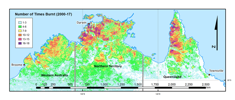
Figure 1: Fire frequency between 2000 and 2017 within 300 km radius of Darwin.
Across the top of Australia from Broome in Western Australia to Townsville in Queensland, there is more than one million people, of whom approximately 14 per cent are Indigenous (Australian Bureau of Statistics 2016). Outside of major towns, Indigenous people comprise a much greater proportion of the total population (Figure 3). In the Kimberley and Top End, about half of the population is Indigenous while in very remote regions, more than 90 per cent of communities are Indigenous peoples (Taylor 2006). Population density in the region is about 0.75 persons per km2, which is low compared to Australian (average three persons per km2) and global standards (Archer et al. 2019). In addition, the non-Indigenous population is concentrated in coastal towns, mainly Broome, Darwin, Cairns, Townsville and Mackay.
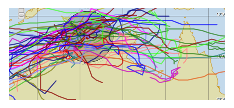
Figure 2: Cyclone tracks between 1970 and 2015 within 300 km radius of Darwin. Source: Bureau of Meteorology 2018
There is a distinct seasonal distribution of cyclones and bushfires across the top end of Australia. The coastal areas experience 11 tropical cyclones every wet season (average between 1981–1982 and 2012–2013, Dowdy 2014) (Figure 4). These are often associated with catastrophic wind speeds, storm surges and heavy flooding. Subcoastal and inland areas experience bushfires that burn extensive areas (Figure 1). Unlike more populous areas with the availability of emergency services organisations and associated infrastructure, most isolated and remote communities lack emergency management amenities and, as such, are at heightened risk in the event of hazardous events (North Australian Indigenous Land and Sea Management Alliance (NAILSMA) 2014a, 2014b, Sangha et al. 2017, Sithole et al. 2017). These issues are well recognised in national policy (Remote Indigenous Advisory Committee 2007, Attorney-General’s Department 2011).
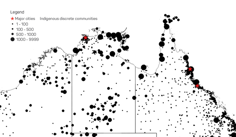
Figure 3: Distribution of Indigenous discrete communities across northern Australia. Source: Australian Bureau of Statistics 2016
To demonstrate a typical emergency management situation from an Indigenous perspective across northern Australia, the Northern Territory was used as an example where three remote communities were selected as case studies to examine the Indigenous context.
To address emergency issues, a collaborative approach is required to build capacity and empower remote communities for the preparation and management of natural hazard events. In particular, government investment in Indigenous ranger groups, for example through the Working on Country and Indigenous Protected Area programs that provide a ready framework for using and developing required capacity. This paper explains how involving Indigenous ranger groups and locals from remote communities could help to develop feasible and sustainable pathways to improve emergency management capacity as well as services in regional and remote locations.
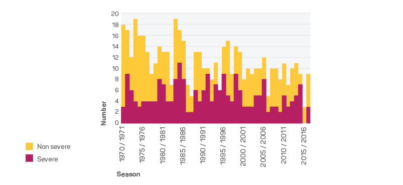
Figure 4: Occurrences of severe and non-severe tropical cyclones in northern Australia between 1970 and 2017. Source: Bureau of Meteorology 2018
Emergency management resources
The Northern Territory is an area of 1.34 million km2 with a population of 228,800. Four major population centres of Darwin, Katherine, Tennant Creek and Alice Springs are home to more than 76 per cent of all residents (Australian Bureau of Statistics 2016). Outside of these centres, 75 per cent of the population is Indigenous (Australian Bureau of Statistics 2016) and reside in 96 discrete communities of greater than 100 people and over 600 family outstations (Bushtel 2018). Notably, Indigenous communities are dispersed across the Territory (Figure 5), unlike other populations that are mostly in major urban centres.
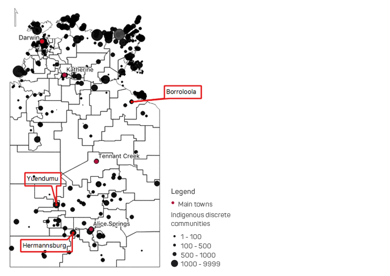
Figure 5: Locations of the three remote communities selected for this study: Borroloola, Hermannsburg and
Yuendmu. Source: ABS (2016) census data
Most of these communities are frequently prone to floods and storms during the wet season (November to March) and extensive bushfires during the dry season (May to October) (Figures 1 and 2) (Russell-Smith et al. 2018). As shown in Figure 6 and Table 1, the Northern Territory Emergency Services (NTES), Northern Territory Fire and Rescue Services (NTFRS) and Bushfires NT, have very limited resources to manage emergency situations in remote communities. Importantly, the resources listed by the emergency services agencies (Figure 6) may not be operational as they are missing (as experienced for one of the three study locations).
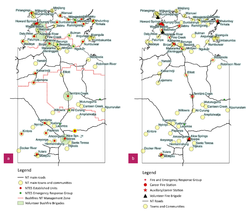
Figure 6: Distribution of emergency services resources and the main towns and communities in the Northern
Territory.
a) NTES resources include established units, emergency response groups, volunteer bushfire brigades and Bushfires NT management zones (https://sites.google.com/site/bfntvolunteers/volunteer-brigades).
b) NTFRS resources include fire stations, fire and emergency response groups and volunteer fire brigades. Source: NTPFES 2016–17 and respective websites: www.pfes.nt.gov.au/Fire-and-Rescue/Locations.aspx and www.pfes.nt.gov.au/Emergency-Service/Your-local-volunteers/Volunteer-location-profiles.aspx
Table 1: Northern Territory emergency services and fire management organisations.
| Organisations | NT Fire and Rescue Service | NT Emergency Services | Bushfires NT | Parks and Wildlife Commission |
| Employees* | 250 | 21 | 22 | 283 |
| Volunteers and Auxiliary Staff | 300 | 360 | 500 | Not known |
|
Main responsibilities |
Fire prevention and |
Management |
Bushfire mitigation and |
Broad management |
*total number, full time and part time
Method
Three remote communities, Borroloola in the Northern Territory Gulf region, and Hermannsburg and Yuendumu in Central Australia (Figure 5) were examined. All of these communities are vulnerable to natural hazards, especially bushfires. Yuendumu and Hermannsburg are located about 300 km and 130 km, respectively from Alice Springs. Borroloola is 900 km southeast of Darwin and is highly vulnerable to cyclones and flooding. Each community comprises 500–800 people.
Indigenous ranger groups from each community were involved to assist with the research. Ranger group members are experienced and skilled in managing fire and other emergency situations (e.g. land searches). Initially, informal discussions were held with the Garawa and Waanyi Garawa rangers at Borroloola. This allowed the identification of issues relevant to the local community. A questionnaire was developed in collaboration with the Garawa and Waanyi Garawa rangers to garner the views of community members. Results were discussed in focus group meetings. Focus group meetings were also held with Indigenous ranger groups in Yuendumu and Hermannsberg. Ethics approval was granted by Charles Darwin University (H17134).
Results
The research revealed that, typically, there is little involvement of local community members in managing and mitigating natural hazard events, emergency management decision-making processes or services delivery. One exception was Hermannsburg (Table 1) where the Tjuwanpa women rangers (trained NTES volunteers) and the men rangers, separately conduct preventive burning around the community. Table 2 provides a summary of the findings as well as the identified emergency-related issues and available resources.
Moreover, there are limited resources available to mitigate and manage natural hazards and emergency situations in each community (Table 2). Access to these resources is restricted and limited to personnel from Police, NTES and NTFRS. Indigenous ranger group members also had limited knowledge about the content or existence of community emergency plans. Where these did exist, they were not readily accessible being either online or as hard copy documents in the local police station.
During the research, ranger groups and other local community members showed marked interest in being involved with community risks of bushfire, flood, search and rescue and vehicle breakdowns. However, there was a general reluctance to be involved in vehicle accidents, except to help with traffic control.
Developing effective approaches
Australia’s National Strategy for Disaster Resilience (Attorney-General’s Department 2011) describes the role of governments in managing natural disasters, particularly by focusing on ‘developing and implementing effective, risk-based land management and planning arrangements and other mitigation activities’. Engaging communities in natural disaster management is a significant step to help local communities and Indigenous ranger groups build resilience in remote communities (Sangha et al. 2017). This was reinforced during the group discussions, ‘…emergency planning needs to have decisions by clan leaders front and centre putting plan together. Plan for the whole country (including outstations)’ (cited in Sithole, Champion & Hunter-Xénié 2018). To this end, appropriate engagement could be achieved through the establishment of a formal Joint Natural Hazards Management Platform (JNHMP) in each remote community (Figure 7). Such a platform will help enhance micro-scale management of natural disasters to deliver multiple benefits to communities.
Table 2: Focus group meeting outcomes from Borroloola, Hermannsburg and Yuendumu
| Topics | Borroloora | Hermannsburg | Yuendumu |
|
Rangers (number of participants |
Garawa and Waanyi Garawa rangers (9–10) |
Tjuwanpa women rangers (9) |
Warlpiri rangers and traditional |
|
Identified main hazards |
Floods, storms, car accidents, bogged vehicles, cyclones and bushfires. |
Floods, bushfire and road accidents. |
Road accidents, land searches and floods. |
|
Current management of natural |
NTFRS FERG* unit and Police deliver emergency services in the event of road accidents, bushfires, floods and cyclones. However, not much effort in mitigating or managing natural hazards. Sea rangers assist during floods with their own boat. |
NTES, Police and NTFRS deliver emergency-related services, involving local NTES volunteers |
Police manage the main emergencies (i.e. road accidents). Local council help in controlling bushfires, if needed. |
|
Ranger current role in emergency management and services delivery |
Rangers or locals are not |
Rangers conduct preventive prescribed burning around the community but are not confident taking a lead role in emergency situations such as bushfires and floods and need further training. |
Rangers and local community members manage land searches. Locals are not involved in decision-making nor managing natural hazards and emergency situations. |
|
Rangers and Indigenous community member willingness to participate in emergency |
Willing to join NTFRS volunteer brigade, to mitigate bushfires in the community and help in other emergencies. Rangers had their first meeting with the NTFRS local area volunteer brigade captain. |
Three women rangers are already NTES volunteers, others are planning to join. |
Rangers and elders did not want to join the volunteer brigade. However, it was suggested that the younger people need to be involved in emergency management. |
|
Engagement of local communities in managing or planning for emergency situations |
Little or no formal involvement to date. |
Some degree of engagement exists between emergency agencies and the Tjuwanpa women rangers. |
Little or no formal involvement to date. Rangers help their community, especially during land searches. |
|
Engagement of local communities in managing or planning for emergency situations |
Emergency management plans are typically kept at the police station. Locals have little idea of what they are about. |
||
|
Existing emergency-related |
NTFRS has a FERG* unit and NTES has a rescue boat. Garawa and Waanyi Garawa rangers have a fire truck and Sea rangers have a boat. |
NTES, NTFRS and Police have their own resources. NTES has an established unit in the community. Tjuwanpa rangers were planning to buy a grassfire unit. |
NTES unit was reported as not functional. The local council owns a fire truck. There are no other emergency resources. |
|
Ranger emergency management and local area knowledge |
Rangers and traditional owners have local knowledge especially of people and areas prone to bushfire and flood and know how to manage bushfires around towns and outstations. They can be trained to manage floods and vehicle breakdowns. Moreover, community members confide in them. |
||
*FERG - Fire and Emergency Response Group, a local volunteer group.
The platform involves linking socio-cultural, natural and institutional structures, knowledge and processes at a community scale to create emergency management plans, policies and procedures in a collaborative way (Figure 7). For example, local knowledge of the landscape (e.g. road access, cultural sites, family outstations) assists in applying prescribed burning and understanding the potential of bushfire spread. Local communities can actively plan for fire management along with relevant fire management agencies (Russell-Smith et al. 2013). Similarly, in the event of cyclones and floods, emergency management organisations need to manage the situation in an effective and culturally appropriate way and in acknowledgement of the local customs and traditions. This includes who should lead discussions, who can talk with whom and when, cultural norms and regulations to approach the elders and traditional owners, and resources and services required by the community. Community networks can help emergency management agencies in raising awareness, planning and preparing for events. They can also share information about road access, people living at family outstations and their health needs (personal communication during focus group meetings). One of the community members explicitly pointed out the need for a meaningful engagement with the community:
We know our people and we know our land. We blackfellas mob should make our own plan for our people. Family still strong and we should look out for our people.(Interview, part of an umbrella project on Building Resilience in North Australian Remote Communities; cited in Sithole, Champion & Hunter-Xénié 2018).
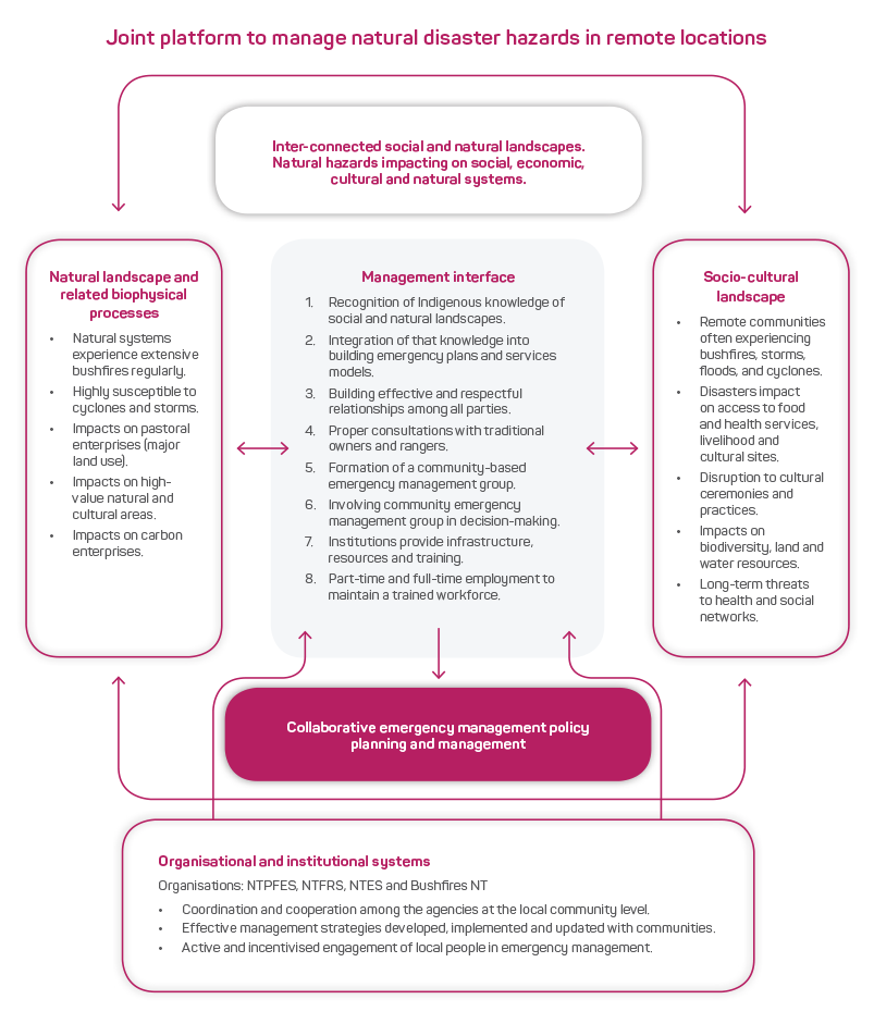
Figure 7: Interactions between natural and socio-cultural systems and the institutions responsible for provisioning resources and services to manage natural hazards and disasters.
Establishing joint platforms helps to address the concerns highlighted in ‘Keeping our mob safe’ A national emergency management strategy for remote Indigenous communities (Remote Indigenous Advisory Committee 2007).
It helps to establish an understanding of the social, cultural and biophysical context to build effective and respectful partnerships between government and people in remote communities. Collaborative arrangements potentially deliver several benefits such as culturally appropriate management of emergencies, cost-effective outcomes for the emergency services organisations and improved mitigation and management of natural ecosystems. However, genuine engagement of the ranger groups and their local communities in a respectful and meaningful manner is essential (Howitt, Havnen & Veland 2012). Ultimately, collaborative arrangements reduce costs for the emergency services agencies by involving a local labour force that is enduring, invested and dedicated, as long as they are provided with appropriate training and resources (Sangha et al. 2017). The JNHMP approach is in line with the Remote Indigenous Advisory Committee emergency management strategy that recognises and accepts collective community decision-making structures as a first priority in emergency situations.
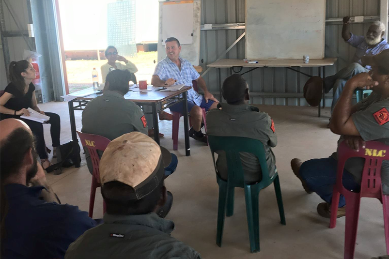
A ranger group in Borroloola discuss their engagement in the emergency management sector for the local area. Image: Kamaljit K. Sangha and Andrew Edwards
Conclusion
Building community resilience in remote communities is a key requirement to address the ‘Keeping our mob safe’ policy framework (Remote Indigenous Advisory Committee 2007). However, effective engagement and partnership with Indigenous communities is an ongoing challenge for emergency services organisations (NAILSMA 2014a, 2014b, ABR DRCS 2017, Sangha et al. 2017). There are practical and long-term solutions to engage and empower communities to identify and mitigate their risk and manage emergency situations. Focus group meetings with the ranger groups who participated in this research clearly demonstrated their willingness and capacity to participate in local emergency planning and decision-making processes.
There are 35 Indigenous ranger groups in the Northern Territory funded through the Working on Country and Indigenous Protected Area programs (Russell- Smith et al. 2019a), which offer some funding security depending on government policy. The ranger groups are contracted to meet a variety of biodiversity conservation targets. However, they could be also contracted to deliver emergency mitigation services to their communities if appropriate training and resources were provided. This was demonstrated by Girrigan rangers in Cardwell following Cylone Yasi in Queensland in 2011 (Phil Rist, Nywaigi traditional owner, sharing Indigenous experience at the Australian Institute for Disaster Resilience conference 2018). The effectiveness of ranger groups as front-line responders could be enhanced using a collaborative platform. A salient example of this collaborative arrangement is the establishment of Volunteer Emergency Services Units by the Western Australia Department of Fire and Emergency Services (DFES) in two remote communities in the Kimberley, Bidyadanga and Beagle Bay. There is genuine engagement between the DFES, the local council and the ranger groups (personal communication Lee Vallance DFES Indigenous Co-ordinator). To date, the ranger groups provide services at no cost and DFES has invested in emergency resources (e.g. a fire truck and control room with modern facilities), training equipment and other materials and services in the communities. If such programs are to be expanded at a community and regional scale to ensure success, security and long-term outcomes, then contractual arrangements are essential.
A total cost-benefit analysis, including marketable and non-marketable aspects, needs to be undertaken to assess the long-term outcomes of any proposed JNHMP arrangements. The rationale that the benefits of engaging ranger groups in planning and providing emergency services will outweigh the costs borne by governments seems credible due to continuous and substantial Commonwealth investment in the ranger programs and the flow of multi-fold benefits. Fire management, undertaken by Arnhem Land Indigenous ranger groups, who are partly self-funded through carbon projects and partly through Commonwealth Working on Country and Indigenous Protected Area programs, is a prime example offering both effective bushfire management and socio-economic benefits, which are contributing significantly to reducing government costs (Russell-Smith et al. 2013, Sangha et al. 2017). Involving Indigenous people in building resilience and, more broadly, developing the northern areas of Australia is outlined by Russell-Smith and co-authors (2019b) who indicate there is a huge potential for land sector-based and local economies in remote communities. At time of print, a detailed cost analysis of the frequent natural disasters in the Northern Territory (i.e. cyclones, storms, floods and bushfires) is being undertaken as part of the Bushfire and Natural Hazards Cooperative Research Centre scenario planning project.
Developing a locally inclusive, participatory emergency management model that genuinely involves Indigenous communities and sets up contractual arrangements, is critical to enhance emergency preparedness and management for remote communities across the north.


