People in Australia are surprised to learn that hundreds of earthquakes occur below our feet every year. The majority are too small to feel, let alone cause any damage. Despite this, we are not immune to large earthquakes.
Australia records at least one magnitude 5 earthquake every year and a magnitude 6 approximately every ten years. In 1968, the small town of Meckering in the wheatbelt of Western Australia was devastated by a magnitude 6.5 earthquake. And who can forget the loss of 13 lives in Newcastle almost 30 years ago from a magnitude 5.4 earthquake?
Earthquake scientists, engineers and emergency managers are always working to answer questions of where the next damaging event will occur and how we can better prepare. It’s impossible to accurately predict when and where an earthquake will occur, but the history of earthquake activity in a region can tell us a lot about its potential risk for the future.
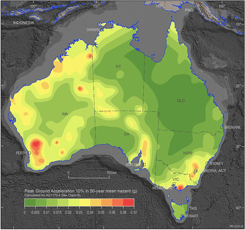
National Seismic Hazard Assessment of Australia map. Image: Geoscience Australia
Many buildings in Australia are constructed without taking earthquakes into consideration. In the aftermath of the Newcastle earthquake in 1989 the earthquake loading standard was incorporated into National Construction Code 1990. This standard requires information on the level of ground shaking that has a ten per cent likelihood of being exceeded in a 50-year period.
The Geoscience Australia National Seismic Hazard Assessment (NSHA) helps define the level of earthquake ground shaking across Australia that has a likelihood of being exceeded in a given time period. The NSHA provides the information required for the Code as well as information for much longer time periods that are required for critical infrastructure.
In October 2018, Geoscience Australia released a new version of the NSHA. This update introduced a host of improvements including converting the earthquake catalogue to a Moment magnitude scale to replace the 1930s-era Richter magnitude scale. The Moment magnitude scale provides a physically based representation of an earthquake’s size and provides consistency with models that estimate ground shaking.
Earthquakes can occur in unanticipated locations where there may be no historical observations. In May 2016, a magnitude 6.1 earthquake ruptured over 20 kms of the ground surface in a remote area west of Uluru in Central Australia. Rupturing of the surface is a rare event in Australia. In November 2018, a magnitude 5.7 earthquake in the Lake Muir region of south-west Western Australia ruptured the surface, this time 6–7 km in length. These events resulted in minimal damage. The same rupture under a major city would have severe to catastrophic effects.
It is impossible to say where the next damaging earthquake will occur, so being prepared for future events is critical. What we can do is be aware of earthquakes and educate people on what to do in the event of an earthquake. Communities can also investigate options to improve homes and buildings to be better prepared should an event occur.
Geoscience Australia is part of a collaborative project with the Shire of York, the WA Department of Fire and Emergency Services and the University of Adelaide to reduce the vulnerability to a major earthquake of the township of York. With this knowledge, the Shire of York, and other towns with similar structures, can strengthen their valuable buildings and be a more resilient community. The project is part of the Bushfire and Natural Hazards CRC project, ‘Cost-effective Mitigation Strategy Development for Building related Earthquake Risk’.