The road network is one component of a region’s disaster resilience context and it is recognised that roads are an important factor in community safety and emergency management capability. This paper presents a case study of an innovative rapid assessment methodology that was developed to identify and prioritise the critical road assets in the vast road network of the Warrumbungle Shire local government area in New South Wales. The case study takes the perspective of roads function and value that support community resilience particularly in times of extreme flood, storm or bushfire. The structure of the methodology facilitates its expansion to include any hazards that may be relevant in an area. This model has transference to other locations where road networks require assessment to assist in emergency management planning and community safety.
Introduction
Road networks connect people and places. Roads are the foundational infrastructure on which communities depend for their daily mobility, transport of goods, access to services and, in times of emergencies, for critical support and evacuation during response and recovery from extreme events. Road networks play a significant role in a community’s capacity for resilience (Anderson et al. 2022). Major investigations into Australian bushfire and flood disasters (Teague et al. 2010; Binskin et al. 2020) also confirm the importance of roads and their contribution to community safety and emergency management capability. Population growth and a changing climate combine to present growing risks of disasters caused by extreme events. The NSW State Infrastructure Strategy 2022-2042 (INSW 2022) states that there is a critical need to address these challenges and to:
…develop place-based resilience and infrastructure adaptation strategies that assess local risk and incorporate infrastructure and non-infrastructure solutions for vulnerable locations across NSW…
(INSW 2022, p.17).
In Australia, local councils are largely responsible for the upkeep of road networks that serve the needs of their communities, providing access to places and services as well as safe egress in emergency situations. With large geographical areas and generally a small ratepayer base, this presents a management challenge for rural and regional councils. Teague et al. (2010) notes that local councils that have the greatest need for resources to keep their communities safe are generally those that are the least well-resourced.
Warrumbungle local government area
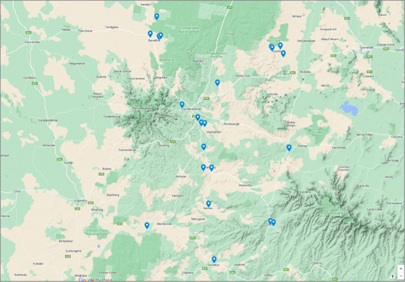
The Warrumbungle local government area is located in the central-western region of NSW with a population of approximately 9,200 people and a land area of 12,380 kms2 (see Figure 1). Towns in the area are Coonabarabran, Coolah, Mendooran, Binnaway, Baradine and Dunedoo, which are connected by an extensive network of both sealed (approx. 1,013 km) and unsealed (approx. 1,500 km) roads.
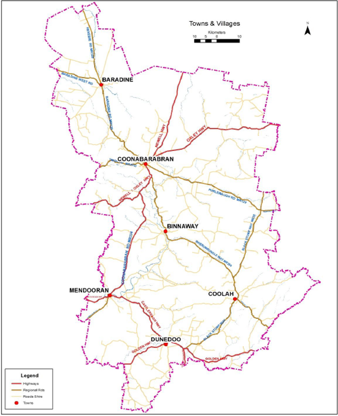
Figure 1: The Warrumbungle local government area is approximately 12,380 kms2.
Source: Warrumbungle Shire Council
The Warrumbungle Shire Council Community Strategic Plan 2022-2037 (WSC 2022) states the community vision as ‘a peaceful and sustainable way of life built by a strong community’ and recognises challenges for council of an ageing population in a large, sparsely populated rural area with a large transport infrastructure network with no corresponding economies of scale.
Extreme weather events such as storms, bushfires and floods have a significant impact on road infrastructure in the area. Damage to roads, bridges and culverts (Figure 2) can complicate or inhibit access to and egress from affected areas, potentially isolating people and property from emergency assistance or evacuation possibilities.
Warrumbungle Shire Council recognised the need to build better hazard resilience for the next 20 years. As such, they commissioned consultants to identify the priority areas in the local government area road network from the perspective of hazard vulnerability, emergency response and community value. The outcomes of the rapid assessment would feed into council’s Disaster Resilience Community Strategic Plan to integrate and future-proof its planning process.
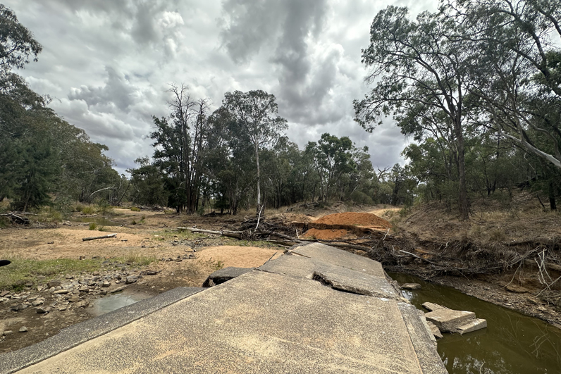
Figure 2: Road damaged by flooding in the Warrumbungle local government area.
Source: Water Technology Pty Ltd
Methodology
Figure 3 illustrates the methodology used in the project. Preliminary desktop research showed that no comparable all-encompassing road infrastructure hazard resilience assessments had been conducted anywhere in Australia, or around the world. Emergency managers consider some features of roads in evacuation modelling but particularly notable was the absence of a community voice in any such work. This observation was supported by conversations with representatives from agencies such as the NSW Reconstruction Authority and regional representatives from the NSW State Emergency Services.
The desktop review offered many ideas that contributed to the development of a tailor-made methodology that commenced with desktop research through analysis of input, field inspections, a SWOT analysis into final recommendations for council.
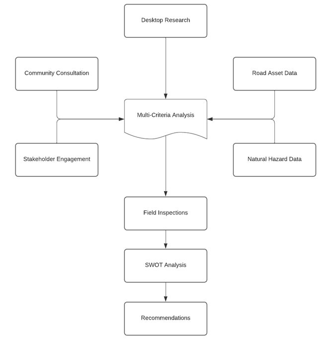
Figure 3: The project methodology from initial research to recommendations stages.
Using risk-based approaches such as those set out in BITRE (2023) and LGNSW (2016), a tailor-made methodology was developed to integrate available road asset details with 3 aspects of hazard risk and resilience of hazard exposure, hazard vulnerability and road asset community value. Indicators for each of these aspects were scored for each road asset according to predetermined Likert scales. This provided a means to carry out a multi-criteria analysis and quantify an overall relative priority ranking incorporating the likelihood (probability) of impact by hazard events with the significance to the community (consequence).
Systematic field inspections of the highest-ranking road assets were carried out to ground-truth the desktop analysis results. A SWOT analysis provided guidance to determine the most plausible strategies for improvement of the road network across the local government area.
Road asset data
Council provided spatial information and attributes for road segments and road assets such as bridges, major culverts, minor culverts and causeways for the entire road network in the local government area as well as an Excel-based natural hazard defects register for individual assets. The database presented 2,546 individual road infrastructure assets of various types for the assessment process consisting of 1,375 road segments and 1,171 road assets (see Table 1).
The asset data and associated attribute tables were mapped in GIS and set up in Excel for assessment through a multi-criteria analysis framework based on evaluations of the level of effect by storm, flood and bushfire (hazard exposure), the role and function in hazard emergencies (hazard vulnerability) and the expressed value to the community (community value).
Natural hazard exposure
Road assets were assessed for their potential exposure to hazards of flood, storm and bushfire (as per the brief for the project) but could be expanded to include any other disturbances. Quantification of the assessment was conducted using a 10-point Likert scale calibrated to the local context (Alkharusi 2022). The assessment and scoring process was informed by publicly available documentation on flood, storm and bushfire hazards in the region such as the Castlereagh Bushfire Risk Management Plan (CBFMC 2012), council’s Local Emergency Management Plan (WSC 2020) and the Warrumbungle Shire Flood Emergency Sub Plan (NSW SES 2013). This was augmented with internal council documentation of historic disaster events and anecdotal evidence gathered during the community consultation and stakeholder engagement process with local emergency services and council staff.
Table 1: Number and types of road infrastructure assets in the Warrumbungle local government area.
| Road segments | 1,375 |
| Highways | 36 |
| Regional roads | 15 |
| Local roads | 339 |
| Streets | 509 |
| Footpaths | 476 |
| Road assets | 1,171 |
| Major culverts | 91 |
| Minor culverts | 658 |
| Causeways | 360 |
| Bridges | 62 |
| Total | 2,546 |
Natural hazard vulnerability
Road assets were assessed for their role and function (intrinsic value) in the road network during extreme hazard events. This value was determined by assessing several road asset characteristics such as location, context, design, size and routing. Quantification of the assessments on such characteristics was carried out using a 10-point Likert scale. The assessment and scoring process was informed by demographic analysis, spatial analysis, internal council mapping for single access trails and anecdotal evidence gathered during the community consultation and stakeholder engagement process.
Community consultation and stakeholder engagement
Council emphasised the importance of the community voice to be reflected in the process and in the outcomes of the project. This aspect of including community’s views and thoughts about how the road network might – or might not – serve their needs is a prominent component of any work aimed at disaster resilience improvement (Anderson et al. 2022; National Resilience Taskforce 2018; INSW 2022).
This project connected with the local community and relevant stakeholders to identify road infrastructure deficiencies and treatments, to identify any education and awareness gaps, and to discover the community's desires to build and strengthen the road network for the next 20 years. Three approaches were employed to carry out this task:
- In-person community consultation sessions in 7 locations in the local government area.
- In-person and online stakeholder engagement with local and regional representatives of NSW SES, NSW RFS, NSW Local Land Services, Transport for NSW, Institute of Public Works Engineering Australasia NSW and ACT as well as various council committees and staff including the Local Emergency Management Committee, Urban Services Manager and the roads team.
- Social Pinpoint online engagement tool.
The Social Pinpoint online engagement tool (Figure 4) is a web-based map that enables anyone with internet access to mark specific road infrastructure components and leave their feedback on what the issues are and why this is important to them. It provides an opportunity for anyone in the communities to provide input, regardless of their location or availability to attend the local consultation sessions. This was particularly important in this large and geographically dispersed community.
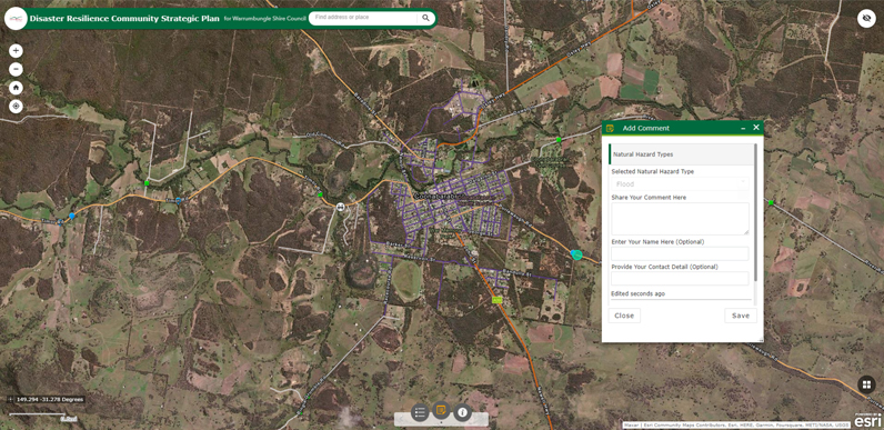
Figure 4: Screenshot of the Social Pinpoint online platform.
Source: Water Technology Pty Ltd
The in-person community consultation sessions and the Social Pinpoint online community engagement tool were advertised and promoted by the council through the Have Your Say webpage (Figure 5), local newspapers and social media channels.
The data collected through the community consultation and stakeholder engagement process informed the scoring of aspects of hazard exposure and hazard vulnerability to develop an understanding of how and why the community appreciates and values specific parts of the region’s road network. The overall data was interpreted and, to accommodate the quantitative multi-criteria analysis, expressed based on a 10-point Likert scale.
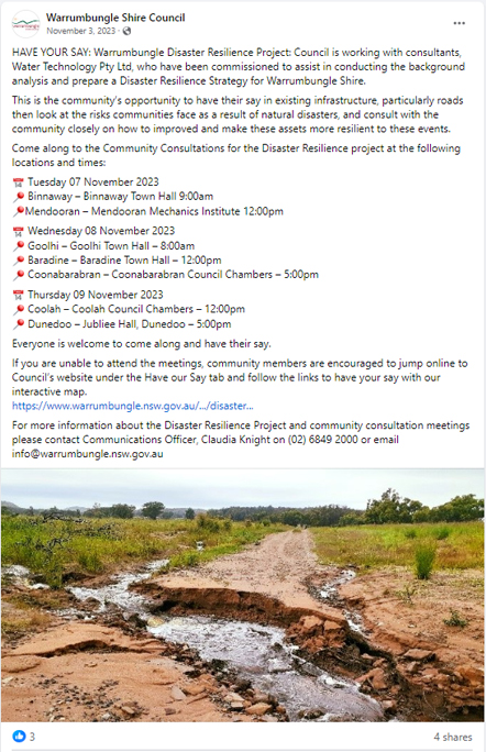
Figure 5: The council Have Your Say webpage, local newspapers and social media were used for community consultation.
Multi-criteria analysis
The scores for hazard exposure, hazard vulnerability and community value were compiled for each road asset and summed to deliver a compound score for each asset (Figure 6). This delivered a list of 144 road infrastructure assets with a relative priority ranking from which the 23 top-ranking assets were selected (Figure 7) for further review using field inspections.
Field inspections
The selected top-ranking assets were physically inspected for the purpose of ground-truthing the desktop-driven analysis and to collect condition monitoring information to support decision-making for maintenance and upgrade strategies. The field inspections were carried out in a systemic manner based on the principles set out in the Road Inspection Manual (IPWEA 2021). The field inspections yielded some slight adjustments in scoring for several of the selected assets and prompted minor fine-tuning of the scoring and ranking methodology. A field inspection report was prepared for each of the 23 road assets.
SWOT analysis and final plan
The strengths, weaknesses, opportunities and threats associated with the natural hazard vulnerabilities and risks to the road-network infrastructure were mapped in a SWOT analysis to identify the elements for the formulation of tactical and strategic measures to improve the resilience of the road network. This review revealed a variety of actions that could be undertaken to build and strengthen hazard resilience for the next 20 years. The prioritised road assets provided a blueprint for future funding to fortify the road network to better enable community safety and protection of property. These details were provided in the final part of the project that was the development of a Disaster Resilience Community Strategic Plan.
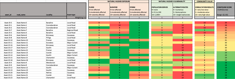
Figure 6: Multi-criteria analysis used to prioritise road assets.
Conclusion
The information and intelligence gathered in the desktop research, the road infrastructure network review, community consultation and stakeholder engagement, the field inspections and the SWOT analysis provided a solid basis to formulate targeted actions that Warrumbungle Shire Council might consider to strengthen its hazard resilience for the next 20 years. While the project only assessed the hazards of flood, bushfire and storms on the road network, other hazards, such as extreme heat and seismic hazards, would also compromise the road network in this region. The straightforward structure of the methodology facilitates its expansion to include any hazard that may be relevant in an area, or perhaps even other types of disturbance. The project provided a high-level identification of those assets in a road infrastructure network that can assist the prioritisation of day-to-day management and maintenance activities of the responsible authority. It has transference to any location where road networks require assessment to assist in better management.