Introduction
Within the bushfire fuel management practice, there is often a clear divide between what occurs on public land and what occurs on private land. Different words are used and different metrics of success are evaluated. In Victoria, Forest Fire Management Victoria compares results to the prescriptions set within the Overall Fuel Hazard Assessment Guide (Government of Victoria 2010) while private property owners look to visual cues on their property and, in unfortunate circumstances, from analysis in the aftermath of a bushfire. Generally speaking, community engagement within fuel management practice is led by fire agencies and local governments with communities receiving information on what they should do and how they should do it.
To flip this concept, the Monbulk Community Fuel Management Group created a fuel management plan that allocated fuel management zones specific to their township and incorporated both public and private land. This framework of allocating fuel management zones to public land was replicated and placed within and around the township. This created a common understanding and a shared language to discuss the community’s exposures and actions to take. The approach was developed through the Dandenong Ranges Bushfire Landscape Project,1 a community based, multi-agency project sponsored and coordinated by Emergency Management Victoria.
The Kalorama/Mt Dandenong community group also took the same approach and developed their own plan. The efforts of these community groups culminated in the Bushfire Fuel Management Guide for the protection of townships and settlements (Southern and Eastern Metropolitan Fuel Management Working Group 2018). This guide has since been used in the roll out of additional township bushfire fuel management plans in priority areas of the Yarra Ranges Council between November 2022 and March 2025.
Fuel management zones surrounding a township
The concept of community township fuel management planning is based on allocating fuel management zones around a township to mitigate the effects of a bushfire. This is a community-led initiative to enhance and develop local approaches and improve collaboration between government agencies and communities. The guide informs this practice and includes 4 fuel management zones, the same as those allocated on public land. The guide sets out objectives and performance measures for each of the zones.
Asset Protection Zone (APZ)
The APZ defines an area that is of most priority to the community. This typically includes the area of higher density housing and the main economic areas (such as a main street). This is typically the area where residents will seek refuge and information during a bushfire event. This also applies to residents of surrounding higher-risk localities who may come into these ‘hub’ townships.
The urban growth boundary can be provided by local councils and is a good starting point when defining this zone. The APZ has the most intensive fuel treatment prescription of the zones but, due to its location being typically within an area of higher density development, the prescription is generally already being met as properties in this area can be smaller with maintained back and front yards. The placement of this zone is a point of focus as all corresponding zones and fuel management activities have the main objective of providing protection to the APZ.
Bushfire Moderation Zone (BMZ)
The BMZ typically encircles the APZ with the aim of reducing speed and intensity of a bushfire approaching a township. The BMZ placement is informed by the landscape risk profile. The zone typically covers larger more densely vegetated properties outside of the central township area.
In the case of the Yarra Junction Community Bushfire Mitigation Group, they decided to exclude the south-eastern corner when defining their APZ as fire approach was less likely from this aspect. Unlike the APZ, properties generally do not meet the prescriptions as defined within the Bushfire Fuel Management Guide. Consequently, there is more opportunity for fuel management discussion and activities within this zone.
Landscape Management Zone (LMZ)
The aim of the LMZ is to protect biodiversity assets while still enabling fuel management activities. Community groups have generally allocated this zone in places such as council managed reserves and private property with high-quality vegetation where there is an option for sensitive fuel management such as hand weeding.
Fuel Management Exclusion Zone (FMEZ)
FMEZs are areas of high ecological value. Vegetation management may still be undertaken for ecological outcomes but not for fuel reduction. This zone is typically placed along waterways with high-quality riparian vegetation.
Council collaboration
To add a strategic lens to Yarra Ranges Council’s Fire Hazard Inspection Program, and to embed local knowledge into existing legislated arrangements, the council aims to incorporate inspections of properties within the community-defined APZ and BMZ areas during each fire season. This is an encouraging process for community members as it gives added value to their work, knowing their community knowledge is informing strategic planning. In addition, as a mechanism to build continued connection between the council and fire agencies, the Municipal Fire Management Planning Committee (MFMPC) has a standing agenda item to include an update from each of the township fuel management groups.
Phoenix fire modelling: a collaborative tool
In collaboration with Forest Fire Management Victoria, township fuel management groups can access analysis of Phoenix Rapidfire modelling. Fire risk analyst staff from Forest Fire Management Victoria provide community members with modelled bushfire scenarios that demonstrate how a fire could approach their township and how it might behave locally. The modelling also informs the placement of fuel management zones. Once allocated, the prescriptions of the zones are fed into the model and community groups can visualise the bushfire mitigation effects of the zone placement. Zones can be adjusted according to what affords the best mitigation results. This is also expressed as a percentage reduction of residual risk. This process gives community members an in-depth understanding of Forest Fire Management Victoria fuel management practices as well as the process that informs it. The collaboration between agency and community strengthens relationships, which is important to the longevity of these projects.
The townships
After receiving funding through the Preparing Australian Communities grant, Yarra Ranges Council sought to extend the application of the fuel management zone model onto priority townships and to support the review of existing township fuel management plans for Monbulk and Kalorama/Mt Dandenong. The townships of Healesville and Yarra Junction were chosen due to their location acting as a local ‘hub’ for surrounding smaller towns that have less facilities. Historically, this has been the case during past bushfires, such as Black Saturday, where residents in nearby small townships such as Chum Creek sought refuge in Healesville. Similarly, during Ash Wednesday, residents within Powelltown and Reefton came into the town centre of Yarra Junction (Colverson and Hill 2012)
This report focuses on the approach of establishing community fuel management plans for the Yarra Junction and Healesville townships. The juxtaposition of the 2 localities highlights 2 unique approaches, demonstrating the complexities of township community fuel management planning and the importance of a place-based approach.
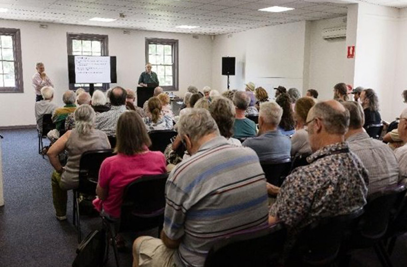
Yarra Junction
Unlike other townships referred to within this report, Yarra Junction did not have an existing community bushfire or emergency group and local environmental groups were relatively inactive. As an initial step to learn about the area and community, local leaders were approached through sporting clubs, local schools and community groups. From this, a contact list was established to maintain discussions. In June 2023, with support from Forest Fire Management Victoria and the Country Fire Authority, Yarra Ranges Council hosted a bushfire modelling event at a community centre in Yarra Junction. Over 30 attendees contributed to the exercise where fire modelling outputs were used to show potential fire scenarios and how they could impact on the town. This was coupled with nominating mock fuel management zones around the town to show the potential differences in fire behaviour including with and without the application of the fuel management zones. The results showed a significant reduction in residual risk with the application of fire management zones. This provided a segue to introduce the township fuel plan concept to attendees.
Contact details were gathered from those who expressed interest in being a part of the project. In August 2023, an introductory meeting was conducted and, in the following months, a committee with a chair and co-chair was elected and work began on allocating the fuel management zones. As a starting point, the predetermined urban growth boundary was used to define the APZ. The group extended the boundary to the north to cover the Neighbourhood Safer Place and the Warburton Highway, which is the main road in and out of the town. This defined APZ encapsulated the town’s higher density development areas and main facilities. The boundaries of the BMZ were a mix of natural features and township boundaries. The southwest corner was excluded as bushfire was deemed less likely to approach from this direction. Little Yarra River and Gordon Creek contain high-quality riparian vegetation so these were designated as LMZ (see Figure 1).
Forest Fire Management Victoria risk analysis staff tested the placement of the zones through Phoenix Rapidfire modelling. The results showed a 16% reduction in residual risk to Yarra Junction when combined with the treatment of the Joint Fuel Management Plan.
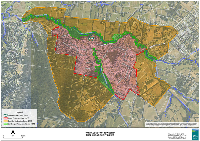
Figure 1: Yarra Junction township fuel management zone map.
Source: Yarra Junction Community Bushfire Mitigation Plan (unpublished), p.3.
In January 2024, while defining these areas, the group held a ‘ground truthing’ day led by a consultant with expertise in ecology and fuel management. The group visited key areas including private property on Milner’s Hill and within the APZ along Outlook Avenue, which was an identified area of concern. As a result of existing relationships that committee members had, property owners could be directly involved and discussed ways to manage their property.
The placement of the BMZ along Millner’s Hill was contentious within the group due to the environmental values present. Some members felt that the area should be excluded entirely while others felt that it should be the priority as the area arguably poses the highest risk to the township. These discussions occurred in the early formation stages of the group so it was particularly important that conversations remained open to alternative views. The resolution came via continual and open discussion where each member was given the time to express their opinion. However, as the area is private property, the decision to act on the prescriptions of the BMZ was up to the landowner. The intention is to provide fuel management information that can be applied according to the context of the property, including its ecological value.
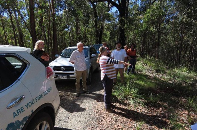
Visiting a committee member’s property during the ‘ground truthing’ process.
Image: Rebecca Walker
The first community event
A particular concern of the group was the lack of bushfire knowledge and awareness within the local community. Improving this awareness was a key objective of the project. In November 2024, in collaboration with Forest Fire Management Victoria and the Country Fire Authority, the group hosted a community event to raise bushfire awareness and to explain the work of the group, including fuel management planning and zone locations the plan. The event was well attended and allowed attendees to search for their property on the fuel management map and speak with committee members on what zone their property was covered by.
Approaching the Yarra Junction community with an existing model for fuel management planning was key to the success of the project. It provided the necessary direction and framework for the newly established group. The progression to defining each zone and having it supported by the results of the fire modelling gave reassurance and confidence that the work was meaningful and that their efforts at the strategic level could have a genuine effect on the township once implemented. Another factor was having a chair elected (by vote) after the group’s inception. The role was allocated to represent and lead the committee. Having a community member lead the group during the formative stage quickly built trust as members felt reassured that the direction of the project was specific to the needs of Yarra Junction. Maintaining momentum from the beginning was important to the chair and to the committee. Action items were recorded, tasked and completed at each monthly meeting. This gave a sense of achievement and encouragement to continue with the process. Figure 2 illustrates the project milestones for the Yarra Junction Community Bushfire Mitigation Group from 2023 to 2025.
Into the future
A priority of the committee was to involve the local community and to provide information about bushfire risk and fuel management. The intention was to not necessarily meet the prescriptions of the fuel management zones, but to engage with the community to achieve a baseline of knowledge. However, the zones provided identified areas for engagement and properties within these areas may be specifically targeted in the future. The committee plans to hold a community event each November. This is planned to coincide with the local fire brigade annual open day.
In addition to the introductory community event, the committee created a publication that could be distributed to all properties throughout Yarra Junction. The ‘What You Need to Know’ pamphlet contains information on basic bushfire principles (weather, terrain, fuel) and gives tips to landowners on how to prepare their property. The pamphlet will be distributed prior to the bushfire season.
The committee will report to the Municipal Fire Management Planning Committee once prior to the bushfire season and again after. This is an opportunity for the committee to raise any concerns in the lead-up to each fire season.
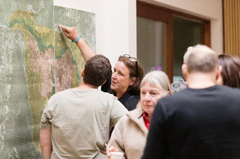
Community members locate their property on the Yarra Junction fuel management map during the community event.
Image: Cathy Ronalds
Healesville
The pre-existing Healesville community emergency group was approached by Yarra Ranges Council in March 2023. Prior to this, the group had received support through a Safer Together facilitator. The continuum of placed-based work through a fuel management plan fast-tracked the process for the group, particularly as a bushfire focus group had already formed.
At the introductory meeting with the bushfire group, it was established that the group had already heard of the township fuel management model and were not interested in the approach for their community. A priority was to expand the group membership to include a broader variety of community representatives by advertising using flyers, newsletters and engaging with existing community groups. This led to a second introductory meeting attended by 15 residents from various facets of the community, which introduced a new energy and enthusiasm to the group. Eventually, this larger group reduced to what was the original group as new attendees were simply curious and not necessarily willing to commit to the workload required. However, having this broader input in the early stage established a framework for the plan. The concept of fuel management zones encircling the township was not supported by the group as they felt it placed too much emphasis on fuel reduction in bushland settings and not enough focus on useful measures in urban and rural landscapes. They also did not agree that an asset protection zone is the central area of a township and is the priority zone for protection.
The Healesville plan
The work spanned just under 2 years with meetings every 2 months throughout. A passionate and knowledgeable community member led the process and delegated sections to group members. The process included all information and recommendations appropriately referenced, which was an important aspect to uphold for the group. The plan consisted of a 3-pronged approach covering major land-use categories including built assets, rural assets and natural ecosystems. The latest bushfire behaviour and ecosystem response research was used to develop reduction strategies across each land-use category.
The plan enables a reader to determine which land-use categories are applicable to their property and provides reduction strategies. For example, a rural property owner may have multiple assets on their property including a home (built asset), a vineyard (rural asset) and a patch of remnant vegetation (natural ecosystems). Using the plan, they could determine what actions to take relevant to these categories. Of particular interest to the group were emerging mitigation measures applicable to rural assets that they felt were least considered in existing publications. These measures included green fire breaks and shelter belt/windbreaks that are detailed within the plan. Additional fact sheets on these measures are anticipated for plan updates.
Members of the Healesville group had a mature understanding of bushfire research and were involved in the environmental area in active community groups and through past and current careers. This pre-existing knowledge enabled a different approach to be confidently explored that they felt better aligned with the needs of the Healesville community. Staff from Forest Fire Management Victoria and the CFA attended initial community meetings as the concept was explored. Attendance changed to being on an as-needed basis as the group explored their own ideas and led the process. Both agencies reviewed the final draft and provided constructive feedback.
Guest speakers
During the process of compiling the plan, the group invited guest speakers with expertise relevant to the 3 land-use categories. Built assets had already been covered in past events with guest speakers including Justin Leonard, a lead researcher in bushfire adaptation at CSIRO. Rural assets expert speaker was David Holmgren, a permaculture and environmental designer who spoke about private property landscape mitigation measures. Workshop attendees also visited a property that had been fire-affected in the 2009 bushfires. In November 2024, Emeritus Professor Mike Clarke presented on his research within fire ecology and discussed the difficulties of using fire as an ecological land management tool. He emphasised the importance of a place-based approach whereby local knowledge is used to inform best practice.
A crucial piece of the plan was enabling the group to take the direction they deemed most appropriate. Having successfully used the fuel zone model in Monbulk and Kalorama, it was assumed that this same model could be used for consistency. However, every community group is unique, not just by locality but by their skill set and interests. It is critical that projects are able to adapt to community values. The Healesville group were only willing to put their energy towards a concept they could whole heartedly own and lead to ensure the community was not misrepresented to fit into a pre-existing model. The group was well-respected and interconnected within the Healesville community so having them lead the process raised the likelihood of community uptake.
Since finalising the mitigation plan, the group has created simplified fact sheets to expand on the measures detailed within the plan, including green fire walls and shelter belts. These will be distributed throughout the community and copies will be available at community locations. The group will report quarterly to the MFMPC.
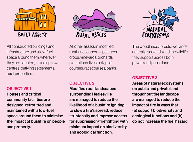
Figure 2: Three land-use categories of the Healesville Bushfire Impact Mitigation Plan.
Source: George et al. 2025, p.7
Conclusion
The reality of meeting prescriptions of fuel management zones has generally not been a priority of community groups as these prescriptions can be quite difficult to adhere to particularly if the area is of higher ecological value. The Kalorama and Monbulk community groups that have been implementing their plans since 2017 have used the fuel management zones to inform their community engagement priorities. The stigma associated with fuel management zones was a point of contention in the Yarra Junction and Healesville groups, with Healesville deciding not to use the model. Committee members of the Yarra Junction group were concerned about the methodology of prescribed burning on public land, which uses the same zone structure as detailed within the Township Fuel Management Guide. The committee was able to move past this through informed conversations that reassured members of the difference when applied in the context of private property
A takeaway from this project is the incorporation of a facilitator to help community members lead and direct the process. Members who join and attend community groups are knowledgeable about their area, about the local plants and about how bushfires have behaved locally. These are the people who will carry a project long after a funded project tenure is complete. Thus, we need to act as the enabler for them to do the work, which means acting as a support mechanism. This requires deep listening that allows a group to work through their own ideas and processes.
The case studies of the Yarra Junction and Healesville community groups show how the application of the model varies and, in some instances, may not be appropriate. It depends entirely on the knowledge, interests and skills of the representative community group.