In October 2023, a paper on the new Hierarchical Predictive Framework1 detailed ways to predict blow-up fire events and the risks of extreme bushfires in southeast Australia. The framework was based on over 20 years of archival data on extreme bushfires and their context. This paper presents the results of the framework’s operational trial carried out over the summer bushfire season of 2023–24 based in Canberra.
At the end of September 2023, there were no alerts issued for the forested areas of south-east Australia, but the potential for alerts was flagged and this required close monitoring. Some drying events in local rivers had occurred indicating increasing flammability of large dead-and-down fuels that could raise the risks of bushfire. At that time, the Canberra Dipole was climbing towards zero at a rapid rate, indicating a real potential for blow-up fire events (BUFEs) early in the fire season.
At the end of October, Level 1 and Level 2 alerts were issued. More river drying events had been logged, causing a Level 2 Alert. As the Dipole passed zero, a pyroCb occurred near Nymboida in New South Wales.2 In early December, the situation was unchanged. Two more pyroCbs had occurred (2023d, Pilliga, NSW, 9 December and 2023e, Pilliga, NSW, 18 December). The Dipole then stopped rising.
This was due to 2 interlinked factors:
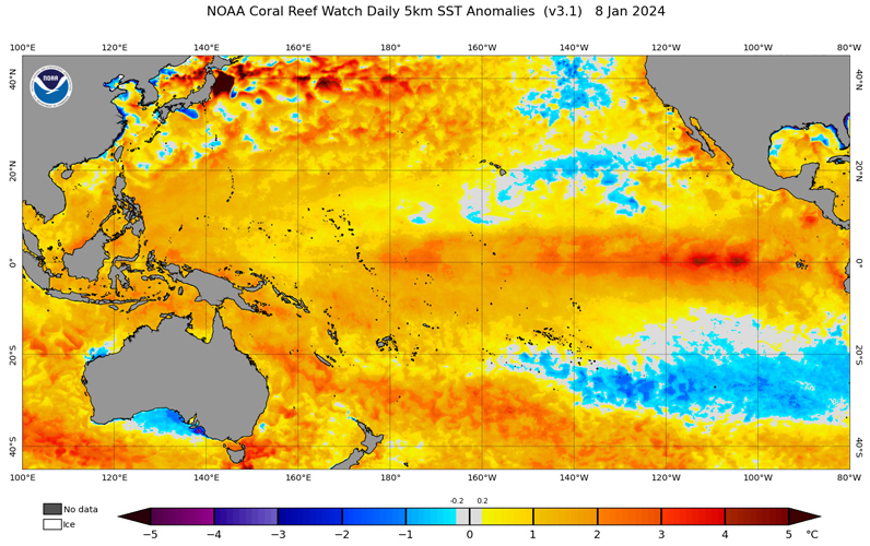
- A persistent warm sea surface temperature anomaly had formed offshore (see Figure 1). This was of such a magnitude that the US National Oceanic and Atmospheric Administration issued a coral reef bleaching alert for that area. The anomaly acted to both moisten the air above it and alter the isobaric patterns on the coast, making rain troughs highly likely.
- Prolonged onshore flows of that moist air interacted with inland troughs, creating heavy rains and reducing land temperature anomalies.
On 24 December, the alerts were downgraded as the entire eastern section of the Australian continent stayed under moist air with frequent rainfalls. Past instances had shown that the BUFE potential could persist until the new hydrological regime settled in, so the Level 1 and Level 2 alerts were classed as ‘ending’. On 8 January, the alerts were cleared. Most river flows had risen to new base levels. This suggested at least one month, if not longer, before new alerts might be required.
On 18 February, no alerts were issued but an advice that monitoring was required was issued due to a series of decreasing river flows. As that series grew, a Level 2 Alert and associated Level 1 Alert were issued on 27 February. This stayed in place until widespread rains associated with an East Coast Low3 arrived in early April. Without anticipated summer heat, this caused all alerts to be cancelled.
A BUFE event occurred northwest of Ballarat in Victoria on 22 February. This led to the addition of a new river flow site from that area to the framework. This initially had a drying event in place, which eased in early April.

Figure 1: Sea surface temperature anomalies from 8 January 2024, which was the peak of the persistent event.
Source: NOAA Satellite and Information Service, at https://coralreefwatch.noaa.gov/satellite/index.php.
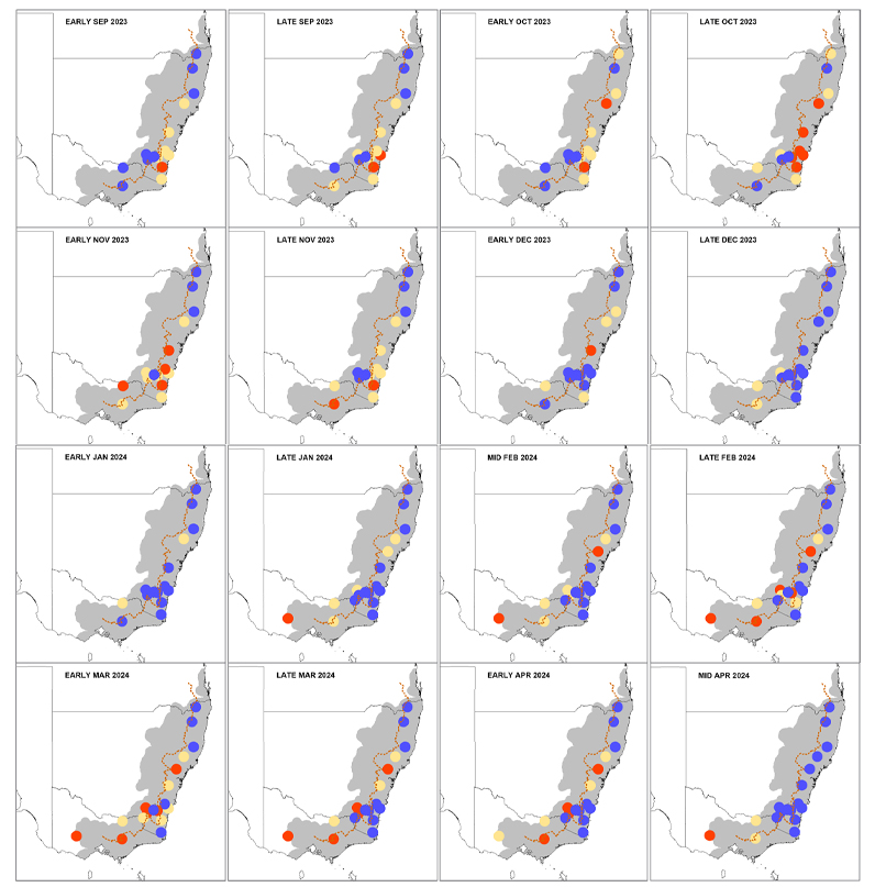
Figure 2 shows the evolution of river drying events throughout the season.
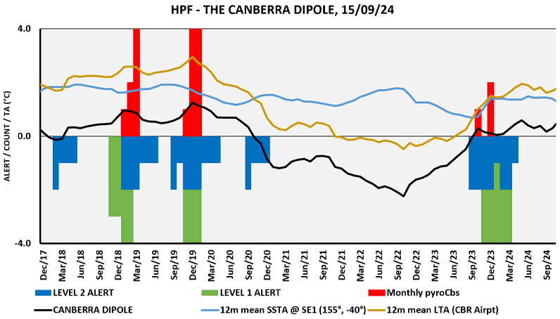
Figure 3 compares the standard Hierarchical Predictive Framework indices since 17 December 2017 and includes the extreme bushfires of summer 2019–20 and the following wet years.
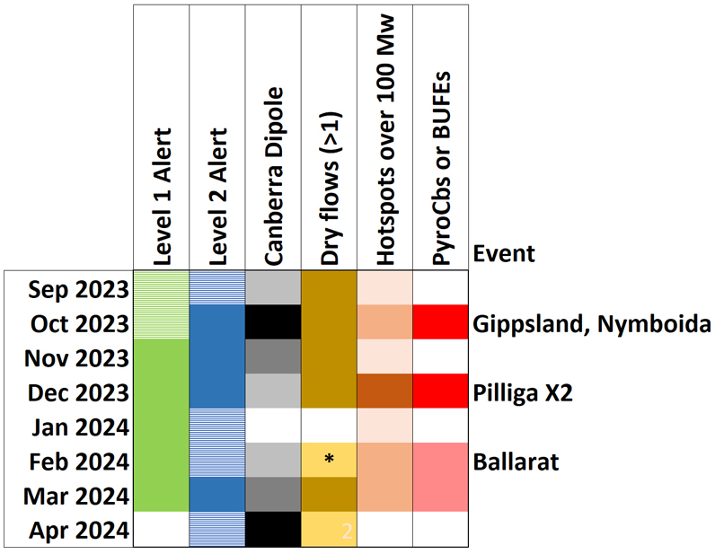
It is instructive to compare time series of the predictions and observations (see Figure 4), which are counts of dry river flows and satellite hotpots. For the latter, this comparison uses VIIRS hotspots with a Fire Radiative Power over 100MW – a hot fire (from NASA Fire Information and Resource Management Service4).

Figure 2: Timeseries of river flow assessments.
Blue shows elevated flows with no risk of drying, orange shows possible drying within a month, and red shows dry. The brown line shows the Great Divide. The pulse of river drying events is clear. Note that the events are not intended to be relevant to their local catchments, rather to the entire study area. Before December, fire activity typically stays north on the Hunter River, during January it spans the whole area, and after that the focus south of Sydney. Note that a new hydrology site west of Melbourne was added In January and played no role in the framework prior to that.

Figure 3: Time series of Hierarchical Predictive Framework products between 2017 and 2014.

Figure 4: Summary of Hierarchical Predictive Framework prediction and observations.
* marks the addition of a new hydrology site near Ballarat, central Victoria.
Also tallied are major fire events. The October 2023 spike in hotspot observations is from a large foehn-wind driven BUFE in the East Gippsland district of Victoria and major fires in the Nymboida area of north eastern New South Wales. The spike in December 2023 is from the protracted fire in the Pilliga Forest in north-central New South Wales, which generated 2 pyroCbs. Even though the Dipole was falling, the river dryings, and thus a Level 2 alert, were still in place. The data showed that, on a daily timescale, hotspot spikes tended to occur while the river dry flow count was increasing.
The Hierarchical Predictive Framework is not a fire danger rating. It does not apply to quasi-steady-state fires that are covered by the Australian Fire Danger Rating System.5 However, the Summer 2023 Seasonal Bushfire Outlook6 (AFAC 2023, p.8), released in October, provided climate outlooks indicating:
…the chance of above average and extreme temperatures; reduced average rainfall over the southern half of the continent; increased heavy rainfall when meteorological conditions are favourable; and a longer fire season, with more extreme fire danger days.
Increased heavy rainfall ended up dominating the summer season from early December onwards for both normal fires and those covered by the Hierarchical Predictive Framework.
At the time of writing, most sites west of Canberra are dry or nearly so. This may be a vital clue to what the next fire season may bring. As always, careful monitoring is required.
Conclusion
This review showed that the Hierarchical Predictive Framework worked as intended in the lead-up to the 2023–24 bushfire season. Following summer, the onset of wet weather placed the entire region into a less flammable state until late February 2024. Had the oceans not reconfigured, through rising sea surface temperature anomalies in early summer, then the framework clearly shows that this summer could have produced many BUFEs. The framework met its objectives for Levels 1 and 2 to provide a clear, long-lead-time outlook for BUFEs in the forests and woodlands of south-east Australia. This successful result successfully concluded the framework’s trail period. In the future, it is recommended that fire behaviour analysts develop skills in using Level 3 of the Hierarchical Predictive Framework that provides fire ground predictions in near-real-time, or for the span of reliable weather forecasts. This is not available through other systems. Adoption of this predictive framework will need collaborative assessment of its performance.


